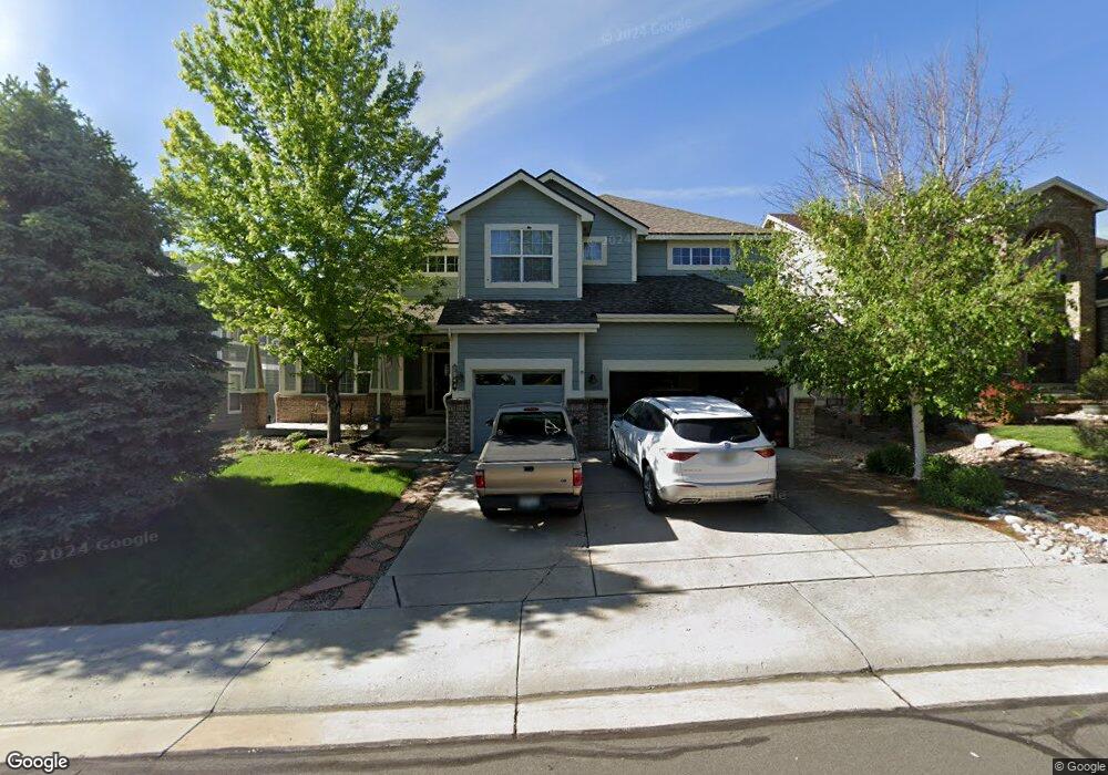
1848 Sapling Ct Castle Rock, CO 80109
Red Hawk NeighborhoodEstimated Value: $894,790 - $1,049,000
4
Beds
4
Baths
3,541
Sq Ft
$271/Sq Ft
Est. Value
About This Home
This home is located at 1848 Sapling Ct, Castle Rock, CO 80109 and is currently estimated at $960,698, approximately $271 per square foot. 1848 Sapling Ct is a home located in Douglas County with nearby schools including Clear Sky Elementary School, Castle Rock Middle School, and Castle View High School.
Ownership History
Date
Name
Owned For
Owner Type
Purchase Details
Closed on
Jan 21, 2011
Sold by
Adams Curt Stephen and Adams Carol Ann
Bought by
The Curt Adams & Carol Adams Joint Livin
Current Estimated Value
Purchase Details
Closed on
Aug 6, 2007
Sold by
Fox Gary M and Fox Susanna B
Bought by
Adams Curt Stephen and Adams Carol Ann
Home Financials for this Owner
Home Financials are based on the most recent Mortgage that was taken out on this home.
Original Mortgage
$150,000
Outstanding Balance
$93,801
Interest Rate
6.69%
Mortgage Type
Unknown
Estimated Equity
$866,897
Purchase Details
Closed on
Oct 29, 2002
Sold by
U S Home Corp
Bought by
Fox Gary M and Fox Susanna B
Home Financials for this Owner
Home Financials are based on the most recent Mortgage that was taken out on this home.
Original Mortgage
$300,000
Interest Rate
6%
Create a Home Valuation Report for This Property
The Home Valuation Report is an in-depth analysis detailing your home's value as well as a comparison with similar homes in the area
Home Values in the Area
Average Home Value in this Area
Purchase History
| Date | Buyer | Sale Price | Title Company |
|---|---|---|---|
| The Curt Adams & Carol Adams Joint Livin | -- | None Available | |
| Adams Curt Stephen | $520,000 | Multiple | |
| Fox Gary M | $408,443 | North American Title |
Source: Public Records
Mortgage History
| Date | Status | Borrower | Loan Amount |
|---|---|---|---|
| Open | Adams Curt Stephen | $150,000 | |
| Previous Owner | Fox Gary M | $300,000 |
Source: Public Records
Tax History
| Year | Tax Paid | Tax Assessment Tax Assessment Total Assessment is a certain percentage of the fair market value that is determined by local assessors to be the total taxable value of land and additions on the property. | Land | Improvement |
|---|---|---|---|---|
| 2025 | $3,690 | $62,770 | $13,530 | $49,240 |
| 2024 | $3,690 | $63,650 | $12,440 | $51,210 |
| 2023 | $3,741 | $63,650 | $12,440 | $51,210 |
| 2022 | $2,555 | $45,290 | $9,080 | $36,210 |
| 2021 | $3,150 | $45,290 | $9,080 | $36,210 |
| 2020 | $2,983 | $43,790 | $7,890 | $35,900 |
| 2019 | $2,998 | $43,790 | $7,890 | $35,900 |
| 2018 | $2,907 | $41,410 | $6,070 | $35,340 |
| 2017 | $2,661 | $41,410 | $6,070 | $35,340 |
| 2016 | $2,592 | $39,280 | $5,780 | $33,500 |
| 2015 | $2,666 | $39,280 | $5,780 | $33,500 |
| 2014 | $2,814 | $38,040 | $5,570 | $32,470 |
Source: Public Records
Map
Nearby Homes
- 1603 Rosemary Ct
- 1388 Rosemary Dr
- 2348 Switch Grass Way
- 1272 Ballata Ct
- 1300 Oleander St
- 1339 Oleander St
- 1288 Oleander St
- 1315 Oleander St
- 1276 Oleander St
- 2204 Jute Ln
- 1509 Gold Hill St
- 2812 Keepsake Way
- 2775 Morningbird Ln
- 1928 Grayside Cir
- 1950 Grayside Cir
- 1537 Dawson Butte Way
- 1468 Thunder Butte Rd
- 1498 Red Cliff Way
- 2021 Grayside Cir
- 2011 Grayside Cir
- 1832 Sapling Ct
- 1832 Sapling Ct Unit 1
- 1864 Sapling Ct
- 1880 Sapling Ct
- 1889 Sapling Ct
- 1917 Sapling Ct
- 1808 Sapling Ct
- 1935 Sapling Ct
- 1896 Sapling Ct
- 1784 Sapling Ct
- 1861 Sapling Ct
- 1912 Sapling Ct
- 1768 Sapling Ct
- 1953 Sapling Ct
- 1928 Sapling Ct
- 1835 Sapling Ct
- 1944 Sapling Ct
- 1977 Sapling Ct
- 1960 Sapling Ct
- 1976 Sapling Ct
Your Personal Tour Guide
Ask me questions while you tour the home.