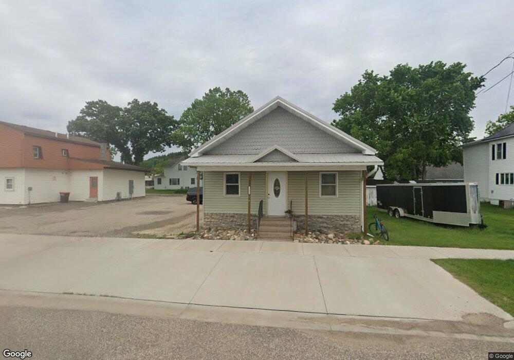
18484 Blair St Whitehall, WI 54773
Estimated Value: $189,582
--
Bed
--
Bath
1,440
Sq Ft
$132/Sq Ft
Est. Value
About This Home
This home is located at 18484 Blair St, Whitehall, WI 54773 and is currently estimated at $189,582, approximately $131 per square foot. 18484 Blair St is a home located in Trempealeau County with nearby schools including Whitehall Memorial Elementary School, Whitehall Memorial Jr./Sr. High School, and Fly Creek Amish School.
Ownership History
Date
Name
Owned For
Owner Type
Purchase Details
Closed on
Aug 24, 2022
Sold by
Fitzgerald Wendy S
Bought by
Fitzgerald Wendy S
Current Estimated Value
Purchase Details
Closed on
Feb 4, 2018
Sold by
Guse Rachelle R and Guse Danlen R
Bought by
Shjh Llc
Home Financials for this Owner
Home Financials are based on the most recent Mortgage that was taken out on this home.
Original Mortgage
$62,773
Interest Rate
3.99%
Mortgage Type
Purchase Money Mortgage
Purchase Details
Closed on
May 7, 2012
Sold by
Midwest Natural Gas Inc
Bought by
Guse Rachelle R and Guse Daniel R
Create a Home Valuation Report for This Property
The Home Valuation Report is an in-depth analysis detailing your home's value as well as a comparison with similar homes in the area
Home Values in the Area
Average Home Value in this Area
Purchase History
| Date | Buyer | Sale Price | Title Company |
|---|---|---|---|
| Fitzgerald Wendy S | $73,300 | Samuel P. Schlewitz | |
| Shjh Llc | -- | -- | |
| Guse Rachelle R | $30,000 | None Available |
Source: Public Records
Mortgage History
| Date | Status | Borrower | Loan Amount |
|---|---|---|---|
| Previous Owner | Shjh Llc | $62,773 |
Source: Public Records
Tax History Compared to Growth
Tax History
| Year | Tax Paid | Tax Assessment Tax Assessment Total Assessment is a certain percentage of the fair market value that is determined by local assessors to be the total taxable value of land and additions on the property. | Land | Improvement |
|---|---|---|---|---|
| 2024 | $2,505 | $118,800 | $4,800 | $114,000 |
| 2023 | $2,391 | $118,800 | $4,800 | $114,000 |
| 2022 | $2,360 | $118,800 | $4,800 | $114,000 |
| 2021 | $2,128 | $73,300 | $4,000 | $69,300 |
| 2020 | $2,050 | $10,930 | $4,000 | $6,930 |
| 2019 | $2,007 | $73,300 | $4,000 | $69,300 |
| 2018 | $1,813 | $73,300 | $4,000 | $69,300 |
| 2017 | $1,863 | $73,300 | $4,000 | $69,300 |
| 2016 | $1,794 | $72,400 | $4,000 | $68,400 |
| 2015 | $1,733 | $72,400 | $4,000 | $68,400 |
| 2014 | $644 | $30,000 | $4,000 | $26,000 |
| 2011 | -- | $0 | $0 | $0 |
Source: Public Records
Map
Nearby Homes
- 36015 Main St
- 36290 Camp St
- 18430 Hillside Dr
- 18144 Anderson St
- 18124 Fredrickson St
- N36836 Us Highway 53 121
- N32838 Briten Rd
- 36121 Ash St
- 35979 Osseo Rd
- 35433 Wayne St
- N34701 County Rd N
- N34855 County Rd S
- 23898 Adams St
- 23942 Tracy St
- N30732 Square Bluff Rd
- 39971 Anderson St
- 517 W Broadway St
- 39885 Winsand Dr
- 102 S Peterson Ave
- N34701 County Rd S
- 18478 Blair St
- 36498 Main St
- 36461 Main St
- 18470 Scranton St
- 36447 Main St
- 18517 Blair St
- 36442 Abrams St
- 18526 Blair St
- 18534 Blair St
- 18407 Scranton St
- 0 Scranton St
- Lot 1 Scranton St
- 18463 Scranton St
- 63420 Main St
- 18453 Scranton St
- 18461 Scranton St
- 18529 Blair St
- 36536 Main St
- 36434 Abrams St
- 36123 Abrams St