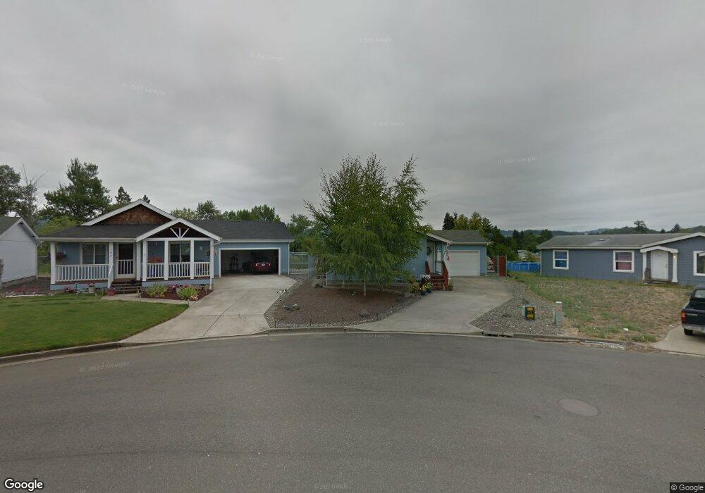
185 Adams Loop Roseburg, OR 97471
Green NeighborhoodEstimated Value: $261,000 - $380,000
3
Beds
2
Baths
1,746
Sq Ft
$179/Sq Ft
Est. Value
About This Home
This home is located at 185 Adams Loop, Roseburg, OR 97471 and is currently estimated at $311,674, approximately $178 per square foot. 185 Adams Loop is a home located in Douglas County with nearby schools including Sunnyslope Elementary School, John C. Fremont Middle School, and Roseburg High School.
Ownership History
Date
Name
Owned For
Owner Type
Purchase Details
Closed on
Jun 9, 2006
Sold by
Norris Robert M and Norris Denise A
Bought by
Norris Robert M and Norris Denise A
Current Estimated Value
Home Financials for this Owner
Home Financials are based on the most recent Mortgage that was taken out on this home.
Original Mortgage
$116,500
Interest Rate
6.55%
Mortgage Type
Fannie Mae Freddie Mac
Purchase Details
Closed on
Feb 1, 2006
Sold by
Navarro Angela M
Bought by
Navarro David J
Create a Home Valuation Report for This Property
The Home Valuation Report is an in-depth analysis detailing your home's value as well as a comparison with similar homes in the area
Home Values in the Area
Average Home Value in this Area
Purchase History
| Date | Buyer | Sale Price | Title Company |
|---|---|---|---|
| Norris Robert M | -- | Amerititle Inc | |
| Navarro David J | -- | Amerititle |
Source: Public Records
Mortgage History
| Date | Status | Borrower | Loan Amount |
|---|---|---|---|
| Closed | Norris Robert M | $116,500 |
Source: Public Records
Tax History Compared to Growth
Tax History
| Year | Tax Paid | Tax Assessment Tax Assessment Total Assessment is a certain percentage of the fair market value that is determined by local assessors to be the total taxable value of land and additions on the property. | Land | Improvement |
|---|---|---|---|---|
| 2025 | $1,474 | $157,605 | -- | -- |
| 2024 | $1,431 | $153,015 | -- | -- |
| 2023 | $1,390 | $148,559 | $0 | $0 |
| 2022 | $1,349 | $144,233 | $0 | $0 |
| 2021 | $1,310 | $140,033 | $0 | $0 |
| 2020 | $1,323 | $135,955 | $0 | $0 |
| 2019 | $1,299 | $131,996 | $0 | $0 |
| 2018 | $1,268 | $128,152 | $0 | $0 |
| 2017 | $1,176 | $119,113 | $0 | $0 |
| 2016 | $1,142 | $114,371 | $0 | $0 |
| 2015 | $1,123 | $111,039 | $0 | $0 |
| 2014 | $1,108 | $109,726 | $0 | $0 |
| 2013 | -- | $117,214 | $0 | $0 |
Source: Public Records
Map
Nearby Homes
- 157 Creekside Ct
- 226 Owyhee Ln
- 124 Aloha Ct
- 231 Owyhee Ln
- 193 Owyhee Ln
- 134 Owyhee Ln
- 145 Owyhee Ln Unit 58
- 383 Little Valley Rd
- 252 Wenaha Ln
- 275 Littlebrook Ln
- 3721 Joe Ave
- 246 Palmdale Ave
- 145 Littlebrook Ln
- 1973 Castle Ave
- 751 E Happy Valley Rd
- 249 Trout Loop
- 150 Buena Vista Ln
- 1951 Austin Rd
- 204 Rainbow Ridge Ave
- 164 Jacob Hale Way
- 175 Adams Loop
- 0 Gelding Ct Unit 9045547
- 0 Gelding Ct Unit 11254613
- 0 Gelding Ct Unit 11668094
- 193 Adams Loop
- 161 Adams Loop
- 195 Adams Loop
- 124 Gelding Ln
- 145 Adams Loop
- 200 Adams Loop
- 205 Adams Loop
- 255 Dark Horse St
- 150 Adams Loop
- 213 Dark Horse St
- 135 Adams Loop
- 275 Dark Horse St
- 216 Adams Loop
- 219 Adams Loop
- 227 Dark Horse St
- 3712 Carnes Rd