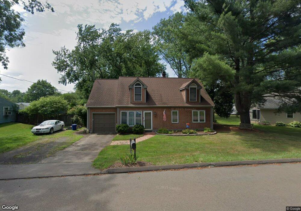
185 Borrmann Rd East Haven, CT 06512
Estimated Value: $369,000 - $421,000
3
Beds
2
Baths
1,775
Sq Ft
$227/Sq Ft
Est. Value
About This Home
This home is located at 185 Borrmann Rd, East Haven, CT 06512 and is currently estimated at $403,321, approximately $227 per square foot. 185 Borrmann Rd is a home located in New Haven County with nearby schools including Deer Run School, East Haven High School, and Pathway School.
Ownership History
Date
Name
Owned For
Owner Type
Purchase Details
Closed on
Oct 31, 1990
Sold by
Diblasi Richard C
Bought by
Bodnar David J
Current Estimated Value
Home Financials for this Owner
Home Financials are based on the most recent Mortgage that was taken out on this home.
Original Mortgage
$122,006
Interest Rate
10.07%
Create a Home Valuation Report for This Property
The Home Valuation Report is an in-depth analysis detailing your home's value as well as a comparison with similar homes in the area
Home Values in the Area
Average Home Value in this Area
Purchase History
| Date | Buyer | Sale Price | Title Company |
|---|---|---|---|
| Bodnar David J | $120,000 | -- |
Source: Public Records
Mortgage History
| Date | Status | Borrower | Loan Amount |
|---|---|---|---|
| Closed | Bodnar David J | $62,000 | |
| Closed | Bodnar David J | $10,400 | |
| Closed | Bodnar David J | $121,497 | |
| Closed | Bodnar David J | $122,006 |
Source: Public Records
Tax History Compared to Growth
Tax History
| Year | Tax Paid | Tax Assessment Tax Assessment Total Assessment is a certain percentage of the fair market value that is determined by local assessors to be the total taxable value of land and additions on the property. | Land | Improvement |
|---|---|---|---|---|
| 2025 | $6,147 | $183,820 | $48,090 | $135,730 |
| 2024 | $6,147 | $183,820 | $48,090 | $135,730 |
| 2023 | $5,735 | $183,820 | $48,090 | $135,730 |
| 2022 | $5,735 | $183,820 | $48,090 | $135,730 |
| 2021 | $5,347 | $156,130 | $45,290 | $110,840 |
| 2020 | $5,347 | $156,130 | $45,290 | $110,840 |
| 2019 | $5,062 | $156,130 | $45,290 | $110,840 |
| 2018 | $5,066 | $156,130 | $45,290 | $110,840 |
| 2017 | $4,926 | $156,130 | $45,290 | $110,840 |
| 2016 | $4,760 | $150,870 | $46,000 | $104,870 |
| 2015 | $4,760 | $150,870 | $46,000 | $104,870 |
| 2014 | $4,835 | $150,870 | $46,000 | $104,870 |
Source: Public Records
Map
Nearby Homes
- 983 N High St
- 965 N High St
- 118 Hellstrom Rd
- 12 Corbin Rd
- 91 Angela Dr
- 153 Grannis St
- 161 Grannis St
- 1192 N High St
- 72 Gene St
- 175 Cherry Hill Rd
- 547 Laurel St
- 372 Old Rock Rd
- 9 Warwick Ln
- 47 Jerimoth Dr Unit 47
- 173 Russo Ave Unit 609
- 173 Russo Ave Unit 410
- 642 Bradley St
- 66 John St
- 24 Laura Cir
- 184 Cherry Hill Rd Unit Lot 4
- 183 Borrmann Rd
- 189 Borrmann Rd
- 181 Borrmann Rd
- 92 Willow Rd
- 34 Hellstrom Rd
- 32 Hellstrom Rd
- 36 Hellstrom Rd
- 186 Borrmann Rd
- 188 Borrmann Rd
- 90 Willow Rd
- 184 Borrmann Rd
- 182 Borrmann Rd
- 192 Borrmann Rd
- 30 Hellstrom Rd
- 190 Borrmann Rd
- 38 Hellstrom Rd
- 88 Willow Rd
- 180 Borrmann Rd
- 177 Borrmann Rd
- 28 Hellstrom Rd