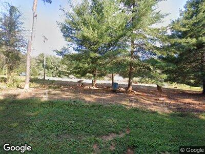
185 Kerney Trail Thurmond, NC 28683
Estimated Value: $349,000 - $490,571
4
Beds
3
Baths
2,352
Sq Ft
$185/Sq Ft
Est. Value
About This Home
This home is located at 185 Kerney Trail, Thurmond, NC 28683 and is currently estimated at $434,143, approximately $184 per square foot. 185 Kerney Trail is a home located in Surry County with nearby schools including Mountain Park Elementary School, Central Middle School, and Surry Central High School.
Ownership History
Date
Name
Owned For
Owner Type
Purchase Details
Closed on
Apr 1, 1985
Current Estimated Value
Purchase Details
Closed on
Jun 1, 1978
Create a Home Valuation Report for This Property
The Home Valuation Report is an in-depth analysis detailing your home's value as well as a comparison with similar homes in the area
Home Values in the Area
Average Home Value in this Area
Purchase History
| Date | Buyer | Sale Price | Title Company |
|---|---|---|---|
| -- | $9,000 | -- | |
| -- | $20,000 | -- |
Source: Public Records
Mortgage History
| Date | Status | Borrower | Loan Amount |
|---|---|---|---|
| Open | Baker Charles L | $175,000 | |
| Closed | Baker Charles Leonard | $50,000 | |
| Closed | Baker Charles Leonard | $213,000 | |
| Closed | Baker Charles Leonard | $72,500 | |
| Closed | Baker Charles Leonard | $227,451 | |
| Closed | Baker Charles L | $30,300 |
Source: Public Records
Tax History Compared to Growth
Tax History
| Year | Tax Paid | Tax Assessment Tax Assessment Total Assessment is a certain percentage of the fair market value that is determined by local assessors to be the total taxable value of land and additions on the property. | Land | Improvement |
|---|---|---|---|---|
| 2024 | $1,972 | $307,540 | $63,270 | $244,270 |
| 2023 | $1,198 | $307,540 | $63,270 | $244,270 |
| 2022 | $1,938 | $307,540 | $63,270 | $244,270 |
| 2021 | $1,972 | $307,540 | $63,270 | $244,270 |
| 2020 | $1,935 | $286,850 | $53,200 | $233,650 |
| 2019 | $1,932 | $286,850 | $0 | $0 |
| 2018 | $1,899 | $286,850 | $0 | $0 |
| 2017 | $1,929 | $286,850 | $0 | $0 |
| 2016 | $1,929 | $286,850 | $0 | $0 |
| 2013 | -- | $291,570 | $0 | $0 |
Source: Public Records
Map
Nearby Homes
- 514 Sylvan Rd
- 2 Sylvan Rd
- 286 Golden Rd
- 142 Old Highway 21
- Lot 16 Laurelwood Rd
- 1156 Hg Lewis Rd
- 1156 H G Lewis Rd
- Lot 3 Laurelwood Rd
- Lot 2 Laurelwood Rd
- Lot 4 Laurelwood Rd
- Lot 1,2,3,4 Laurelwood Rd
- 0 Old Railroad Grade Rd
- Lot1 Mining School Rd
- TBD Us Highway 21
- 4121 Mining Ridge Church Rd
- 251 Devotion Farm Way
- 4300 S Center Church Rd
- 4270 S Center Church Rd
- 2122 S Center Church Rd
- 00 Noah Hayes Rd
- 185 Kerney Trail
- Rt. 1 Kearney Trail
- Rt.1 Kearney Trail
- 155 Hg Lewis Rd
- 282 Hg Lewis Rd
- 201 H G Lewis Rd
- 340 Hg Lewis Rd
- 000 Hg Lewis Rd
- 208 Possum Trot Rd
- 264 Possum Trot Rd
- 346 Possum Trot Rd
- 283 Possum Trot Rd
- 122 Hg Lewis Rd
- 325 Possum Trot Rd
- 2001 Zephyr Mountain Park Rd
- 339 Possum Trot Rd
- 00 Possum Trot Rd
- 386 Possum Trot Rd
- 147 Sylvan Rd
- Lot 1 and Lot 2 Possum Trot Rd
