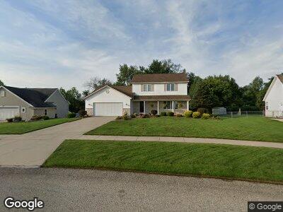
1850 Misty Ridge SW Byron Center, MI 49315
Estimated Value: $452,000 - $620,000
--
Bed
1
Bath
2,096
Sq Ft
$248/Sq Ft
Est. Value
About This Home
This home is located at 1850 Misty Ridge SW, Byron Center, MI 49315 and is currently estimated at $520,646, approximately $248 per square foot. 1850 Misty Ridge SW is a home located in Kent County with nearby schools including Brown Elementary School, Robert L. Nickels Intermediate School, and Byron Center West Middle School.
Ownership History
Date
Name
Owned For
Owner Type
Purchase Details
Closed on
Sep 24, 2004
Sold by
Bell Roger and Bell Dorothy
Bought by
Rings Jeffery A and Rings Tina M
Current Estimated Value
Home Financials for this Owner
Home Financials are based on the most recent Mortgage that was taken out on this home.
Original Mortgage
$164,000
Interest Rate
5.93%
Mortgage Type
Purchase Money Mortgage
Create a Home Valuation Report for This Property
The Home Valuation Report is an in-depth analysis detailing your home's value as well as a comparison with similar homes in the area
Home Values in the Area
Average Home Value in this Area
Purchase History
| Date | Buyer | Sale Price | Title Company |
|---|---|---|---|
| Rings Jeffery A | $214,000 | -- |
Source: Public Records
Mortgage History
| Date | Status | Borrower | Loan Amount |
|---|---|---|---|
| Open | Bell Roger | $124,000 | |
| Closed | Rings Jeffery A | $149,500 | |
| Closed | Rings Jeffery A | $164,000 | |
| Previous Owner | Bell Roger | $18,000 | |
| Previous Owner | Bell Roger | $184,000 | |
| Previous Owner | Bell Roger | $168,000 | |
| Previous Owner | Bell Roger | $5,000 |
Source: Public Records
Tax History Compared to Growth
Tax History
| Year | Tax Paid | Tax Assessment Tax Assessment Total Assessment is a certain percentage of the fair market value that is determined by local assessors to be the total taxable value of land and additions on the property. | Land | Improvement |
|---|---|---|---|---|
| 2024 | $2,891 | $202,300 | $0 | $0 |
| 2023 | $2,764 | $187,300 | $0 | $0 |
| 2022 | $3,853 | $166,700 | $0 | $0 |
| 2021 | $3,750 | $147,200 | $0 | $0 |
| 2020 | $2,544 | $134,000 | $0 | $0 |
| 2019 | $3,584 | $133,700 | $0 | $0 |
| 2018 | $3,584 | $125,900 | $23,500 | $102,400 |
| 2017 | $3,487 | $121,000 | $0 | $0 |
| 2016 | $3,362 | $115,300 | $0 | $0 |
| 2015 | $3,305 | $115,300 | $0 | $0 |
| 2013 | -- | $106,300 | $0 | $0 |
Source: Public Records
Map
Nearby Homes
- 1832 Kingsland Dr SW
- 1716 Gloryfield Dr
- 1912 Creekside Dr SW
- 1942 Creekside Dr SW
- 1950 Creekside Dr SW
- 1798 Gloryfield Dr SW
- 1791 Gloryfield Dr SW
- 2150 Creekside Dr SW Unit 69
- 1740 Athearn Dr SW
- 1691 Bayleaf Dr
- 1666 Bayleaf Dr
- 1753 Portadown Rd
- 1439 Beaconsfield St SW
- 1697 Portadown Rd
- 1724 Worthing St SW
- 1760 Julienne Ct SW
- 1760 Julienne Ct SW
- 1760 Julienne Ct SW
- 1760 Julienne Ct SW
- 1760 Julienne Ct SW
- 1850 Misty Ridge SW
- 1850 Misty Ridge Blvd
- 1838 Misty Ridge SW
- 1864 Misty Ridge SW
- 1864 Misty Ridge SW
- 1822 Misty Ridge Blvd
- 1878 Misty Ridge SW
- 1859 Misty Ridge SW
- 1814 Misty Ridge Blvd
- 1817 Misty Ridge SW
- 1877 Misty Ridge SW
- 1896 Misty Ridge Blvd
- 8242 Alro Dr SW
- 8250 Alro Dr SW
- 1891 Misty Ridge Blvd
- 1798 Misty Ridge Blvd
- 1814 Morning Dew Dr SW
- 1891 Misty Ridge SW
- 8195 Landstar Dr SW
- 1784 Misty Ridge Blvd