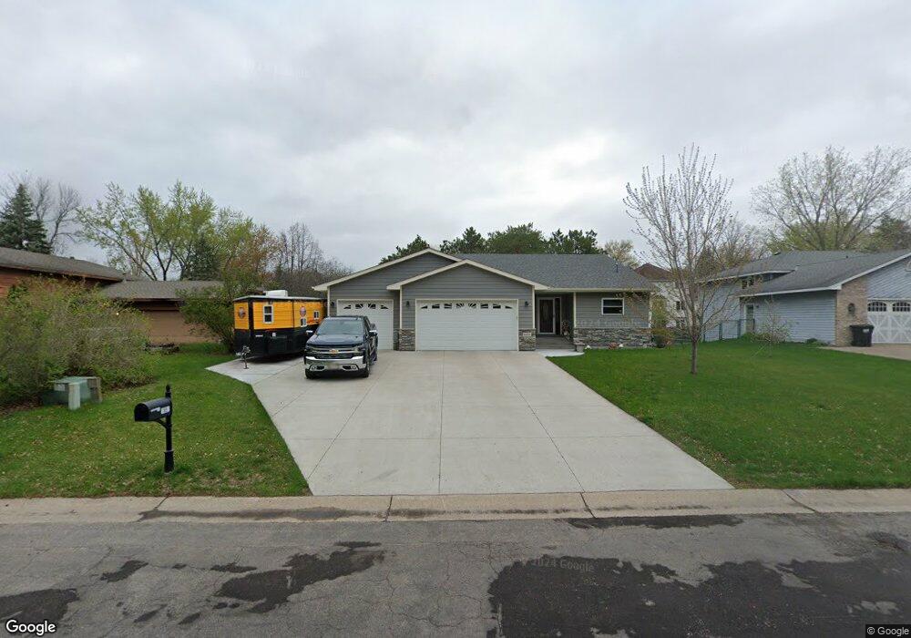
1851 131st Ave NW Coon Rapids, MN 55448
Estimated Value: $384,000 - $417,000
4
Beds
2
Baths
1,296
Sq Ft
$314/Sq Ft
Est. Value
About This Home
This home is located at 1851 131st Ave NW, Coon Rapids, MN 55448 and is currently estimated at $406,951, approximately $314 per square foot. 1851 131st Ave NW is a home located in Anoka County with nearby schools including Lucile Bruner Elementary School, Morris Bye Elementary School, and Laughlin Junior/Senior High School.
Ownership History
Date
Name
Owned For
Owner Type
Purchase Details
Closed on
May 31, 2002
Sold by
Sundlad Richard D and Sundlad Deborah M
Bought by
Upton Robert Harrison and Upton Julie Sue
Current Estimated Value
Purchase Details
Closed on
May 29, 1997
Sold by
Sparks Jeffrey Wayne and Sparks Sharyl
Bought by
Sundblad Richard D and Sundblad Deborah M
Purchase Details
Closed on
Mar 10, 1997
Sold by
Sparks Tina M
Bought by
Sparks Jeffrey W
Create a Home Valuation Report for This Property
The Home Valuation Report is an in-depth analysis detailing your home's value as well as a comparison with similar homes in the area
Home Values in the Area
Average Home Value in this Area
Purchase History
| Date | Buyer | Sale Price | Title Company |
|---|---|---|---|
| Upton Robert Harrison | $184,700 | -- | |
| Sundblad Richard D | $125,000 | -- | |
| Sparks Jeffrey W | $2,500 | -- |
Source: Public Records
Tax History Compared to Growth
Tax History
| Year | Tax Paid | Tax Assessment Tax Assessment Total Assessment is a certain percentage of the fair market value that is determined by local assessors to be the total taxable value of land and additions on the property. | Land | Improvement |
|---|---|---|---|---|
| 2025 | $4,289 | $408,300 | $90,000 | $318,300 |
| 2024 | $4,289 | $403,600 | $87,000 | $316,600 |
| 2023 | $3,972 | $400,500 | $72,000 | $328,500 |
| 2022 | $3,643 | $401,100 | $72,000 | $329,100 |
| 2021 | $3,577 | $329,300 | $56,000 | $273,300 |
| 2020 | $3,645 | $316,400 | $56,000 | $260,400 |
| 2019 | $2,776 | $309,000 | $56,000 | $253,000 |
| 2018 | $2,614 | $234,700 | $0 | $0 |
| 2017 | $2,409 | $216,000 | $0 | $0 |
| 2016 | $2,453 | $196,900 | $0 | $0 |
| 2015 | $2,410 | $196,900 | $50,000 | $146,900 |
| 2014 | -- | $165,100 | $35,400 | $129,700 |
Source: Public Records
Map
Nearby Homes
- 1687 131st Ln NW
- 1776 133rd Ave NW
- 1930 127th Cir NW
- 1520 129th Ave NW
- 13416 Swallow St NW
- 13519 Partridge Cir NW
- 12760 Raven St NW
- 12554 Grouse St NW
- 12796 Bluebird St NW
- 1593 126th Ln NW
- 1450 126th Ln NW
- 2147 125th Ln NW
- 1234 128th Cir NW
- 12365 Jay St NW
- 2068 124th Ln NW
- 1625 124th Ave NW
- 13182 Zion St NW
- 2270 137th Ln NW
- 12463 Drake St NW
- 2740 132nd Ln NW
- 1861 131st Ave NW
- 1845 131st Ave NW
- 1862 131st Ln NW
- 1907 131st Ave NW
- 1872 131st Ln NW
- 1852 131st Ln NW
- 1831 131st Ave NW
- 1854 131st Ave NW
- 1882 131st Ln NW
- 1834 131st Ave NW
- 1821 131st Ave NW
- 1900 131st Ave NW
- 1906 131st Ave NW
- 1842 131st Ln NW
- 13119 Martin St NW
- 13103 Martin St NW
- 1910 131st Ave NW
- 13135 Martin St NW
- 1867 131st Ln NW
- 1877 131st Ln NW