NOT LISTED FOR SALE

1851 W Bancroft St Toledo, OH 43606

Ottawa Neighborhood

Estimated Value: $65,727

0.46 Acre
$142,885 Price per Acre
20,038 Sq Ft Lot

Last Sold October 11, 2013

Last sale price $27,500

Est. 139% increase in value since last sale

Current estimated payment $433/month

38 Days on Market

About This Lot

As of October 2013

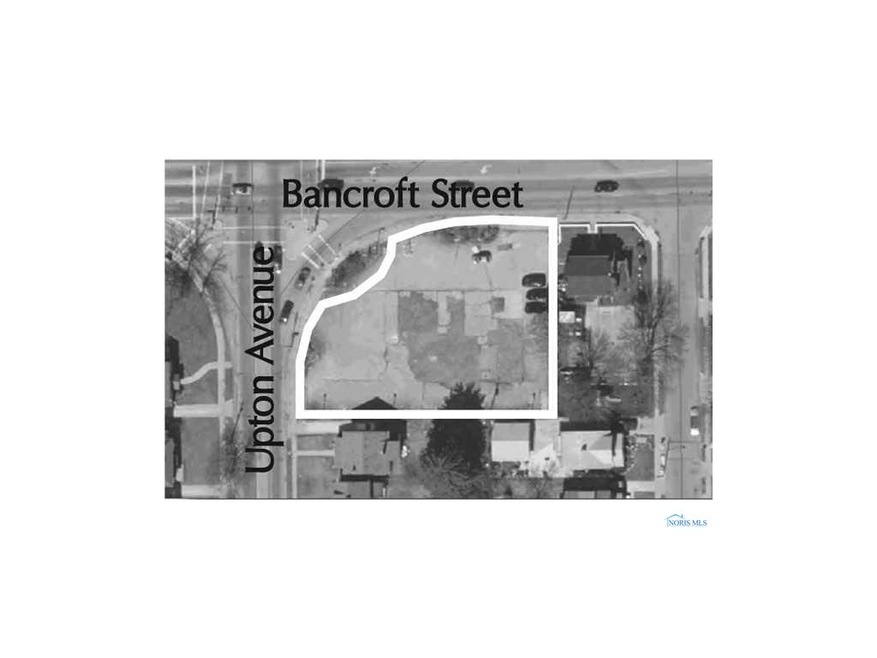
Absolute auction Thursday September 19th at 1816 W. Bancroft. See website for auction brochure and details. Price may not reflect additional buyers premium.

Last Agent to Sell the Property

Pamela Rose

Pamela Rose Auction Company License #2024001978 Listed on: 08/13/2013

Co-Listed By

Michael Murray

Pamela Rose Auction Company License #0000200818

Last Buyer's Agent

MLS NON

NON MLS MEMBER

Property Details

Property Type

  • Land

Est. Annual Taxes

  • $2,371

Lot Details

  • 0.46 Acre Lot
  • Property fronts a private road
  • Property fronts an easement
  • Level Lot

Schools

  • Robinson Elementary School
  • Scott High School

Community Details

  • Parkside Subdivision

Listing and Financial Details

  • Assessor Parcel Number 12-04034, 12-04047

Property Details

Property Type

Land

Est. Annual Taxes

$2,371

Lot Details

0

Listing Details

  • Topography: Level
  • Property Type: Land
  • Property Sub Type: Land
  • Lot Size Acres: 0.46
  • Lot Size: 150x141xIRR
  • Road Frontage Type: Easement, Private Road
  • Road Surface Type: Paved
  • Co List Office Mls Id: LOSS04
  • Co List Office Phone: (419) 794-0090
  • Inclusions: ,,
  • Subdivision Name: Parkside
  • Property Sub Type Additional: Land
  • Special Features: Auction

Interior Features

  • Possible Use: Commercial, Retail

Exterior Features

  • Lot Features: Buildable, Level
  • Disclosures: Sellers Disclosure Not Available
  • Other Structures: None

Utilities

  • Utilities: Electricity Available, Natural Gas Available, Sewer Available, Water Available
  • Sewer: Sanitary, Storm Sewer
  • Water Source: Not Connected, Public

Condo/Co-op/Association

  • Community Features: Sidewalks

Schools

  • Junior High Dist: Toledo

Lot Info

  • Development Status: Other
  • Parcel #: 12-04034, 12-04047
  • Zoning Description: c
  • ResoLotSizeUnits: Acres

MLS Schools

  • Elementary School: Robinson
  • HighSchool: Scott

Ownership History

Date Name Owned For Owner Type

Purchase Details

Closed on
Apr 2, 2024
Sold by
Carter Delano
Bought by
Ak Bancroft Llc
Total Days on Market
38
Current Estimated Value
$65,727

Purchase Details

Closed on
Mar 20, 2017
Sold by
Slow Recovery Acquisitions Llc
Bought by
Carter Delano

Home Financials for this Owner

Home Financials are based on the most recent Mortgage that was taken out on this home.
Original Mortgage
$40,000
Interest Rate
4.15%
Mortgage Type
Commercial

Purchase Details

Listed on
Aug 13, 2013
Closed on
Oct 11, 2013
Sold by
S & S Properties Ii B U Center Llc
Bought by
Slow Recovery Acquisitions Llc
Seller's Agent
Pamela Rose
Pamela Rose Auction Company
Buyer's Agent
MLS NON
NON MLS MEMBER
List Price
$27,500
Sold Price
$27,500

Home Financials for this Owner

Home Financials are based on the most recent Mortgage that was taken out on this home.
Avg. Annual Appreciation
7.75%

Purchase Details

Closed on
Jun 6, 2001
Sold by
Jones Jerry L and Jones Deloris A
Bought by
Stewart Land Company Llc

Home Financials for this Owner

Home Financials are based on the most recent Mortgage that was taken out on this home.
Original Mortgage
$25,000
Interest Rate
7.16%
Mortgage Type
Commercial

Purchase Details

Closed on
Dec 4, 1997
Sold by
Service Station Holdings
Bought by
Bp Exploration & Oil Inc

Purchase Details

Closed on
Jan 16, 1990

Purchase Details

Closed on
Aug 10, 1988
Source: Public Records

Range of Values:

Collateral Analytics

Collateral Analytics Collateral Analytics AVMs (Automated Valuation Model) employ a number of statistical approaches combined with neighborhood-specific comparable selection guarantees the most up-to-date and precise valuations.

Not Available

Collateral Analytics does not have data for the current month. Please view the chart for historical values.

ICE

ICE Mortgage Technology ICE Mortgage Technology’s AVM (Automated Valuation Model) is a state-of-the-art online residential property valuation tool that provides a quick and accurate estimate of the value of almost any home in the U.S.

Not Available

ICE Mortgage Technology does not have data for the current month. Please view the chart for historical values.

First American

First American First American Data & Analytics’ next-generation AVM combines unrivaled data assets with a blended ensemble of valuation models to produce highly accurate, reliable valuations you can trust.

Not Available

First American does not have data for the current month. Please view the chart for historical values.

Quantarium

Quantarium Quantarium’s valuation service, repeatedly proven the industry’s most accurate and comprehensive, is supercharged with a self-learning and auto-tuning AI engine that continually becomes smarter and more accurate as it processes daily inputs from the industry’s leading RE data lake.

Not Available

Quantarium does not have data for the current month. Please view the chart for historical values.

Average Value
Not Available
List Price
Sold Price
Create a Home Valuation Report for This Property
The Home Valuation Report is an in-depth analysis detailing your home's value as well as a comparison with similar homes in the area

Home Values in the Area

Source: Public Records

Average Home Value in this Area


Source: Public Records

Purchase History

Date Buyer Sale Price Title Company
Ak Bancroft Llc $46,000 None Listed On Document
Carter Delano $40,000 None Available
Slow Recovery Acquisitions Llc $27,500 None Available
Stewart Land Company Llc $50,000 --
Bp Exploration & Oil Inc $70,000 --
-- $150,000 --
-- -- --
Source: Public Records

Mortgage History

Date Status Borrower Loan Amount
Previous Owner Carter Delano $40,000
Previous Owner S&S Properties Ii B U Center Llc $300,000
Previous Owner Stewart Land Co Llc $349,000
Previous Owner Stewart Land Company Llc $25,000
Source: Public Records

Property History

Date Event Price Change Sq Ft Price
10/11/2013 10/11/13 Sold $27,500 0.0% --
09/19/2013 09/19/13 Pending -- -- --
08/12/2013 08/12/13 For Sale $27,500 -- --
Source: Northwest Ohio Real Estate Information Service (NORIS)

Tax History Compared to Growth

Source: Public Records

Tax History

Year Tax Paid Tax Assessment Tax Assessment Total Assessment is a certain percentage of the fair market value that is determined by local assessors to be the total taxable value of land and additions on the property. Land Improvement
2024 $2,371 $9,695 $8,155 $1,540
2023 $1,498 $9,695 $8,155 $1,540
2022 $1,483 $9,695 $8,155 $1,540
2021 $1,463 $9,695 $8,155 $1,540
2020 $1,588 $9,345 $7,875 $1,470
2019 $1,501 $9,345 $7,875 $1,470
2018 $1,508 $9,345 $7,875 $1,470
2017 $2,453 $9,625 $8,120 $1,505
2016 $2,480 $27,500 $23,200 $4,300
2015 $1,593 $27,500 $23,200 $4,300
2014 $1,284 $9,630 $8,120 $1,510
2013 $856 $9,630 $8,120 $1,510
Source: Public Records

Agents Affiliated with this Home

  • Section Image
  • Section Image
See All Agents

Map

Source: Northwest Ohio Real Estate Information Service (NORIS)

MLS Number: 5061196

Northwest Ohio Real Estate Information Service (NORIS)

APN: 12-04047