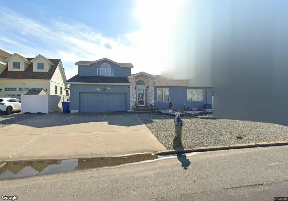
1861 Compass Ct Toms River, NJ 08753
Estimated Value: $958,841 - $1,327,000
5
Beds
3
Baths
2,183
Sq Ft
$501/Sq Ft
Est. Value
About This Home
This home is located at 1861 Compass Ct, Toms River, NJ 08753 and is currently estimated at $1,093,960, approximately $501 per square foot. 1861 Compass Ct is a home located in Ocean County.
Ownership History
Date
Name
Owned For
Owner Type
Purchase Details
Closed on
Jun 16, 2025
Sold by
Flaherty Sean P and Flaherty Lori A
Bought by
Flaherty Family Trust and Flaherty
Current Estimated Value
Purchase Details
Closed on
Jun 23, 2011
Sold by
Reffie James A and Reffie Deborah A
Bought by
Flaherty Sean and Flaherty Lori A
Home Financials for this Owner
Home Financials are based on the most recent Mortgage that was taken out on this home.
Original Mortgage
$412,000
Interest Rate
4.62%
Mortgage Type
New Conventional
Create a Home Valuation Report for This Property
The Home Valuation Report is an in-depth analysis detailing your home's value as well as a comparison with similar homes in the area
Home Values in the Area
Average Home Value in this Area
Purchase History
| Date | Buyer | Sale Price | Title Company |
|---|---|---|---|
| Flaherty Family Trust | -- | None Listed On Document | |
| Flaherty Sean | $525,000 | Fidelity Natl Title Ins Co |
Source: Public Records
Mortgage History
| Date | Status | Borrower | Loan Amount |
|---|---|---|---|
| Previous Owner | Flaherty Sean | $412,000 |
Source: Public Records
Tax History Compared to Growth
Tax History
| Year | Tax Paid | Tax Assessment Tax Assessment Total Assessment is a certain percentage of the fair market value that is determined by local assessors to be the total taxable value of land and additions on the property. | Land | Improvement |
|---|---|---|---|---|
| 2025 | $11,756 | $645,600 | $275,000 | $370,600 |
| 2024 | $11,175 | $645,600 | $275,000 | $370,600 |
| 2023 | $10,775 | $645,600 | $275,000 | $370,600 |
| 2022 | $10,775 | $645,600 | $275,000 | $370,600 |
| 2021 | $10,223 | $408,100 | $197,500 | $210,600 |
| 2020 | $10,178 | $408,100 | $197,500 | $210,600 |
| 2019 | $9,737 | $408,100 | $197,500 | $210,600 |
| 2018 | $9,607 | $408,100 | $197,500 | $210,600 |
| 2017 | $9,525 | $408,100 | $197,500 | $210,600 |
| 2016 | $9,276 | $408,100 | $197,500 | $210,600 |
| 2015 | $8,925 | $408,100 | $197,500 | $210,600 |
| 2014 | $8,497 | $408,100 | $197,500 | $210,600 |
Source: Public Records
Map
Nearby Homes
- 1850 Ensign Ct
- 1836 Ensign Ct
- 1939 Ship Ct
- 8 Pumpshire Rd
- 1145 Kenton Dr
- 1916 Waters Edge Dr Unit 16
- 1813 Waters Edge Dr
- 2517 Waters Edge Dr Unit 17
- 1019 Waters Edge Dr
- 141 Yellowbank Rd
- 230 Christoffer Terrace
- 890 Fairview Dr
- 5 Dublin Ct
- 169 S Shore Dr
- 1083 Crystal Dr
- 1035 Tralee Dr
- 1214 Waters Edge Dr Unit 14
- 193 Bay Stream Dr
- 2 Cedar Tree Ln
- 173 Bay Stream Dr
- 1857 Compass Ct
- 1865 Compass Ct
- 1853 Compass Ct
- 1869 Compass Ct
- 1862 Compass Ct
- 1866 Compass Ct
- 1858 Compass Ct
- 1849 Compass Ct
- 1862 Starboard Ct
- 1854 Compass Ct
- 1873 Compass Ct
- 1858 Starboard Ct
- 1866 Starboard Ct
- 1854 Starboard Ct
- 1870 Starboard Ct
- 1874 Compass Ct
- 1850 Compass Ct
- 1845 Compass Ct
- 1877 Compass Ct
- 1850 Starboard Ct