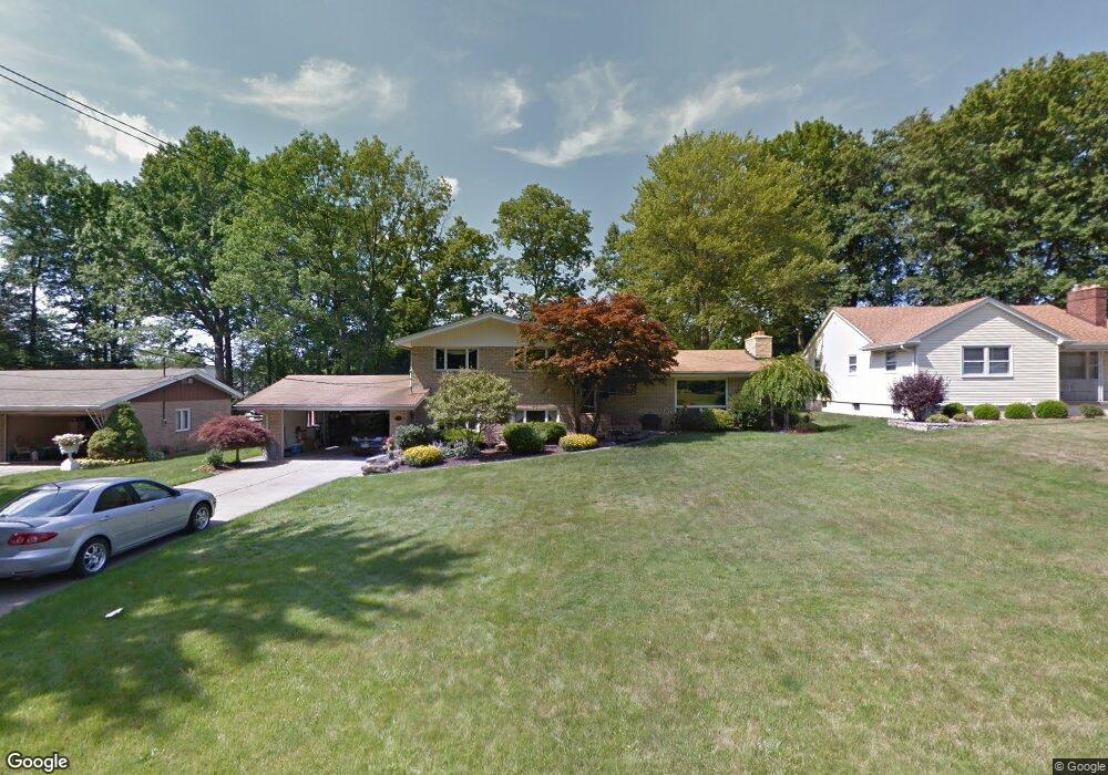
1862 Cover Dr Youngstown, OH 44514
Estimated Value: $233,000 - $314,000
3
Beds
3
Baths
2,316
Sq Ft
$125/Sq Ft
Est. Value
About This Home
This home is located at 1862 Cover Dr, Youngstown, OH 44514 and is currently estimated at $289,069, approximately $124 per square foot. 1862 Cover Dr is a home located in Mahoning County with nearby schools including Poland Union Elementary School, Poland Middle School, and Poland Seminary High School.
Ownership History
Date
Name
Owned For
Owner Type
Purchase Details
Closed on
Sep 6, 1991
Bought by
Brocker Brad G and Brocker Heide
Current Estimated Value
Create a Home Valuation Report for This Property
The Home Valuation Report is an in-depth analysis detailing your home's value as well as a comparison with similar homes in the area
Home Values in the Area
Average Home Value in this Area
Purchase History
| Date | Buyer | Sale Price | Title Company |
|---|---|---|---|
| Brocker Brad G | $104,000 | -- |
Source: Public Records
Tax History Compared to Growth
Tax History
| Year | Tax Paid | Tax Assessment Tax Assessment Total Assessment is a certain percentage of the fair market value that is determined by local assessors to be the total taxable value of land and additions on the property. | Land | Improvement |
|---|---|---|---|---|
| 2024 | $4,626 | $90,480 | $10,220 | $80,260 |
| 2023 | $4,570 | $90,480 | $10,220 | $80,260 |
| 2022 | $3,259 | $53,590 | $10,420 | $43,170 |
| 2021 | $3,265 | $53,590 | $10,420 | $43,170 |
| 2020 | $3,278 | $53,590 | $10,420 | $43,170 |
| 2019 | $2,958 | $44,290 | $8,610 | $35,680 |
| 2018 | $2,785 | $44,290 | $8,610 | $35,680 |
| 2017 | $2,782 | $44,290 | $8,610 | $35,680 |
| 2016 | $2,652 | $40,440 | $8,610 | $31,830 |
| 2015 | $2,601 | $40,440 | $8,610 | $31,830 |
| 2014 | $2,610 | $40,440 | $8,610 | $31,830 |
| 2013 | $2,579 | $40,440 | $8,610 | $31,830 |
Source: Public Records
Map
Nearby Homes
- 1827 Alverne Dr
- 1738 Island Dr
- 1804 Alverne Dr
- 1 Michigan Ave
- 8360 South Ave
- 43 Venloe Dr
- 1894 Lealand Ave
- 2035 Woodward Ave
- 34 Venloe Dr
- 1859 Mathews Rd
- 1890 Mathews Rd
- 0 Mathews Rd Unit 5149232
- 0 Mathews Rd Unit 5143059
- 829 Pearson Cir
- 2295 Bel Aire Ln
- 816 Pearson Un#1
- 912 Pearson Cir Unit 5
- 2379 Clyde St
- 918 Pearson Cir Unit 4
- 857 Maple Ridge Dr
- 1868 Cover Dr
- 1856 Cover Dr
- 1874 Cover Dr
- 1901 Wendy Ln
- 1853 Massachusetts Ave
- 1867 Massachusetts Ave
- 1880 Cover Dr
- 1875 Massachusetts Ave
- 1903 Wendy Ln
- 1886 Cover Dr
- 1841 Massachusetts Ave Unit 2
- 1841 Massachusetts Ave Unit 1
- 1871 Cover Dr
- 1892 Cover Dr
- 1909 Wendy Ln
- 1887 Massachusetts Ave
- 1877 Cover Dr
- 1910 Wendy Ln
- 1898 Cover Dr
- 1860 Massachusetts Ave Unit 4