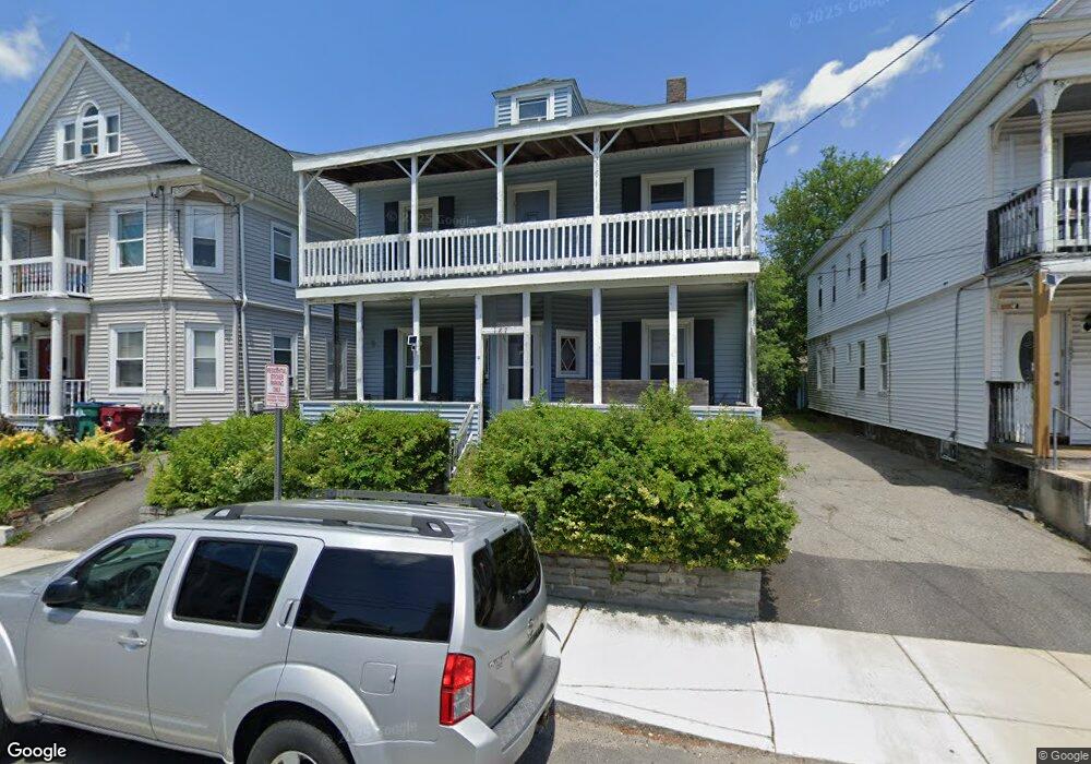
187 University Ave Lowell, MA 01854
Pawtucketville NeighborhoodEstimated Value: $504,000 - $553,000
3
Beds
2
Baths
1,876
Sq Ft
$287/Sq Ft
Est. Value
About This Home
This home is located at 187 University Ave, Lowell, MA 01854 and is currently estimated at $537,745, approximately $286 per square foot. 187 University Ave is a home located in Middlesex County with nearby schools including Joseph McAvinnue Elementary School, Charlotte M. Murkland Elementary School, and Charles W. Morey Elementary School.
Ownership History
Date
Name
Owned For
Owner Type
Purchase Details
Closed on
Jun 7, 2001
Sold by
Rudy Keith A
Bought by
Dally Bryant R and Dally Mary
Current Estimated Value
Home Financials for this Owner
Home Financials are based on the most recent Mortgage that was taken out on this home.
Original Mortgage
$172,050
Outstanding Balance
$65,250
Interest Rate
7.08%
Mortgage Type
Purchase Money Mortgage
Estimated Equity
$472,495
Purchase Details
Closed on
Apr 30, 1996
Sold by
Warren Five Cents Sb
Bought by
Rudy Keith
Home Financials for this Owner
Home Financials are based on the most recent Mortgage that was taken out on this home.
Original Mortgage
$72,650
Interest Rate
7.81%
Mortgage Type
Purchase Money Mortgage
Purchase Details
Closed on
Nov 2, 1995
Sold by
Larose Joseph A
Bought by
Warren Five Cents Sb
Create a Home Valuation Report for This Property
The Home Valuation Report is an in-depth analysis detailing your home's value as well as a comparison with similar homes in the area
Home Values in the Area
Average Home Value in this Area
Purchase History
| Date | Buyer | Sale Price | Title Company |
|---|---|---|---|
| Dally Bryant R | $177,400 | -- | |
| Dally Bryant R | $177,400 | -- | |
| Rudy Keith | $76,500 | -- | |
| Rudy Keith | $76,500 | -- | |
| Warren Five Cents Sb | $68,000 | -- | |
| Warren Five Cents Sb | $68,000 | -- |
Source: Public Records
Mortgage History
| Date | Status | Borrower | Loan Amount |
|---|---|---|---|
| Open | Warren Five Cents Sb | $172,050 | |
| Closed | Warren Five Cents Sb | $172,050 | |
| Previous Owner | Warren Five Cents Sb | $72,650 |
Source: Public Records
Tax History Compared to Growth
Tax History
| Year | Tax Paid | Tax Assessment Tax Assessment Total Assessment is a certain percentage of the fair market value that is determined by local assessors to be the total taxable value of land and additions on the property. | Land | Improvement |
|---|---|---|---|---|
| 2025 | $5,337 | $464,900 | $158,100 | $306,800 |
| 2024 | $5,087 | $427,100 | $137,900 | $289,200 |
| 2023 | $4,728 | $380,700 | $114,600 | $266,100 |
| 2022 | $4,488 | $353,700 | $104,200 | $249,500 |
| 2021 | $4,189 | $311,200 | $90,600 | $220,600 |
| 2020 | $3,932 | $294,300 | $84,700 | $209,600 |
| 2019 | $3,761 | $267,900 | $78,400 | $189,500 |
| 2018 | $3,678 | $255,600 | $74,700 | $180,900 |
| 2017 | $3,805 | $255,000 | $67,900 | $187,100 |
| 2016 | $3,211 | $211,800 | $56,900 | $154,900 |
| 2015 | $3,121 | $201,600 | $58,200 | $143,400 |
| 2013 | $2,954 | $196,800 | $71,800 | $125,000 |
Source: Public Records
Map
Nearby Homes
- 181 University Ave
- 189 University Ave
- 189 University Ave Unit 1
- 179 University Ave
- 179 University Ave Unit 2
- 179 University Ave Unit 1
- 195 University Ave
- 14 Dracut St
- 12 Dracut St
- 20 Dracut St
- 199 University Ave
- 199 University Ave Unit 3
- 199 University Ave Unit 1
- 201 University Ave
- 190 White St
- 173 University Ave
- 26 Dracut St
- 184 University Ave
- 180 University Ave
- 176 University Ave