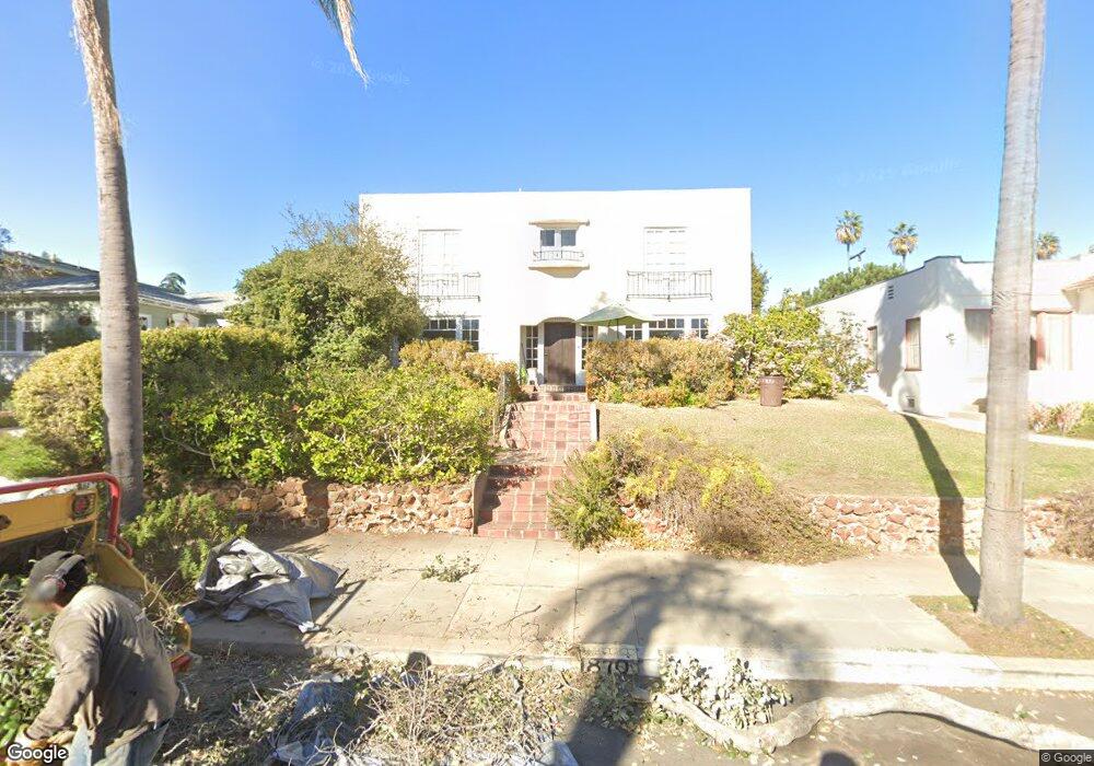
1870 Sheridan Ave San Diego, CA 92103
Mission Hills NeighborhoodEstimated Value: $2,298,000 - $2,566,000
4
Beds
3
Baths
2,592
Sq Ft
$939/Sq Ft
Est. Value
About This Home
This home is located at 1870 Sheridan Ave, San Diego, CA 92103 and is currently estimated at $2,433,771, approximately $938 per square foot. 1870 Sheridan Ave is a home located in San Diego County with nearby schools including Grant K-8, Richard Henry Dana Middle School, and Roosevelt International Middle School.
Ownership History
Date
Name
Owned For
Owner Type
Purchase Details
Closed on
Jul 16, 2020
Sold by
Brown Linda Rose
Bought by
Brown Linda R and Linda Brown Family Trust
Current Estimated Value
Purchase Details
Closed on
Dec 10, 1996
Sold by
Brown Linda R and Brown David L
Bought by
Brown Linda Rose
Purchase Details
Closed on
Apr 8, 1994
Sold by
Leigh Dolores Gorton and Gorton Dolores
Bought by
Dolores Gorton Leigh 1994 Trust
Create a Home Valuation Report for This Property
The Home Valuation Report is an in-depth analysis detailing your home's value as well as a comparison with similar homes in the area
Home Values in the Area
Average Home Value in this Area
Purchase History
| Date | Buyer | Sale Price | Title Company |
|---|---|---|---|
| Brown Linda R | -- | None Available | |
| Brown Linda Rose | -- | Old Republic Title Company | |
| Dolores Gorton Leigh 1994 Trust | -- | -- |
Source: Public Records
Tax History Compared to Growth
Tax History
| Year | Tax Paid | Tax Assessment Tax Assessment Total Assessment is a certain percentage of the fair market value that is determined by local assessors to be the total taxable value of land and additions on the property. | Land | Improvement |
|---|---|---|---|---|
| 2025 | $5,470 | $458,537 | $251,944 | $206,593 |
| 2024 | $5,470 | $449,547 | $247,004 | $202,543 |
| 2023 | $5,347 | $440,733 | $242,161 | $198,572 |
| 2022 | $5,204 | $432,092 | $237,413 | $194,679 |
| 2021 | $5,166 | $423,620 | $232,758 | $190,862 |
| 2020 | $5,103 | $419,277 | $230,372 | $188,905 |
| 2019 | $5,011 | $411,056 | $225,855 | $185,201 |
| 2018 | $4,684 | $402,997 | $221,427 | $181,570 |
| 2017 | $80 | $395,096 | $217,086 | $178,010 |
| 2016 | $4,496 | $387,350 | $212,830 | $174,520 |
| 2015 | $4,429 | $381,533 | $209,634 | $171,899 |
| 2014 | $4,358 | $374,060 | $205,528 | $168,532 |
Source: Public Records
Map
Nearby Homes
- 1864 Sunset Blvd
- 1753 W Lewis St
- 1860 W Montecito Way
- 4232 Arden Way
- 1728 W Lewis St
- 2120 Pine St
- 3770 Keating St
- 2147 Pine St
- 1329 Fort Stockton Dr
- Lot 19 Randolph St
- 1695 Neale St
- 1694 Torrance St
- 3625 Keating St Unit 4
- 3903 California St Unit 3
- 4472 Hortensia St
- 2045 W California St
- 1806 Mckee St Unit A2
- 1806 Mckee St Unit A9
- 3972 Jackdaw St
- 3972 Jackdaw St Unit 109
- 1860 Sheridan Ave
- 1876 Sheridan Ave
- 1852 Sheridan Ave
- 1871 Sunset Blvd
- 1863 Sunset Blvd
- 1875 Sunset Blvd
- 1890 Sheridan Ave
- 1844 Sheridan Ave
- 1883 Sunset Blvd
- 1845 Sheridan Ave
- 1851 Sunset Blvd
- 1875 Sheridan Ave
- 1867 Sheridan Ave
- 4107 Saint James Place
- 1885 Sheridan Ave
- 1845 Sunset Blvd
- 1840 Sheridan Ave
- 1859 Sheridan Ave
- 1889 Sunset Blvd
- 1808 Lyndon Rd