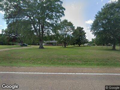
1871 Highway 79 N Mc Neil, AR 71752
Estimated Value: $107,000 - $226,000
--
Bed
2
Baths
1,512
Sq Ft
$104/Sq Ft
Est. Value
About This Home
This home is located at 1871 Highway 79 N, Mc Neil, AR 71752 and is currently estimated at $157,139, approximately $103 per square foot. 1871 Highway 79 N is a home located in Columbia County.
Ownership History
Date
Name
Owned For
Owner Type
Purchase Details
Closed on
Sep 29, 2021
Sold by
Derek Mobbs
Bought by
Guzman-Ayala Camilo and Mancera Cruz
Current Estimated Value
Home Financials for this Owner
Home Financials are based on the most recent Mortgage that was taken out on this home.
Original Mortgage
$125,860
Outstanding Balance
$117,477
Interest Rate
2.8%
Mortgage Type
New Conventional
Purchase Details
Closed on
Jun 11, 2012
Sold by
Keeley Janis L
Bought by
Mobbs Derek and Mobbs Katherine
Home Financials for this Owner
Home Financials are based on the most recent Mortgage that was taken out on this home.
Original Mortgage
$121,300
Interest Rate
3.8%
Mortgage Type
Stand Alone Refi Refinance Of Original Loan
Create a Home Valuation Report for This Property
The Home Valuation Report is an in-depth analysis detailing your home's value as well as a comparison with similar homes in the area
Home Values in the Area
Average Home Value in this Area
Purchase History
| Date | Buyer | Sale Price | Title Company |
|---|---|---|---|
| Guzman-Ayala Camilo | $140,000 | Bell Boyd & Mcmahen Pllc | |
| Mobbs Derek | $120,000 | -- |
Source: Public Records
Mortgage History
| Date | Status | Borrower | Loan Amount |
|---|---|---|---|
| Open | Guzman Ayala Camilo | $125,860 | |
| Closed | Guzman-Ayala Camilo | $125,860 | |
| Previous Owner | Mobbs Derek | $121,300 |
Source: Public Records
Tax History Compared to Growth
Tax History
| Year | Tax Paid | Tax Assessment Tax Assessment Total Assessment is a certain percentage of the fair market value that is determined by local assessors to be the total taxable value of land and additions on the property. | Land | Improvement |
|---|---|---|---|---|
| 2024 | $792 | $24,585 | $2,264 | $22,321 |
| 2023 | $720 | $19,150 | $1,130 | $18,020 |
| 2022 | $464 | $19,150 | $1,130 | $18,020 |
| 2021 | $464 | $19,150 | $1,130 | $18,020 |
| 2020 | $720 | $19,150 | $1,130 | $18,020 |
| 2019 | $867 | $19,150 | $1,130 | $18,020 |
| 2018 | $552 | $20,650 | $1,130 | $19,520 |
| 2017 | $811 | $21,570 | $910 | $20,660 |
| 2016 | -- | $21,570 | $910 | $20,660 |
| 2015 | -- | $21,570 | $910 | $20,660 |
| 2013 | -- | $0 | $0 | $0 |
Source: Public Records
Map
Nearby Homes
- 143 Columbia Road 45
- 1100 Columbia Road 59
- 000 Columbia Road 59
- 00 Columbia Road 47
- 20 ac Columbia Rd 68
- 000 Columbia Road 62 W
- 2830 W Columbia Road 62
- 13 Tanglewood
- 6 Tanglewood
- 1909 Karen Cir
- 0 Regency Cir
- Lot 2 Deer Creek Dr
- 2516 Belair Dr
- 00 U S Highway 82
- 1604 Karen Cir
- 1619 Karen Cir
- 2413 Belair Dr
- Lot 1 Bethel Rd
- 1507 Shady Ln
- 8 Asbury Dr
- 1871 Highway 79 N
- 1261 Highway 79 N
- 1771 Highway 79 N
- 1821 Highway 79 N
- 1821 Highway 79 N
- 1821 Hwy 79 N
- 1761 Highway 79 N
- 1961 Highway 79 N
- 1735 Highway 79 N
- 1330 Highway 79 N
- 1360 Highway 79 N
- 1883 Highway 79 N
- 2071 Highway 79 N
- 2120 Hwy 79 N
- 2120 Highway 79 N
- 2161 Highway 79 N
- 1320 E North St
- 2160 Highway 79 N
- 2270 Highway 79 N
- 460 E Columbia
