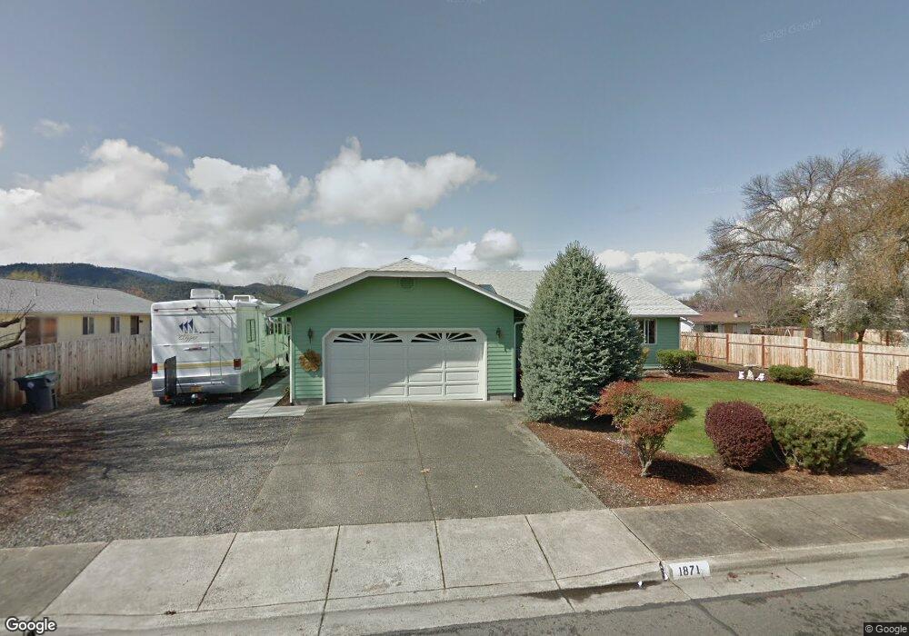
1871 Marys Way Central Point, OR 97502
Estimated Value: $418,000 - $446,000
3
Beds
2
Baths
1,682
Sq Ft
$259/Sq Ft
Est. Value
About This Home
This home is located at 1871 Marys Way, Central Point, OR 97502 and is currently estimated at $434,900, approximately $258 per square foot. 1871 Marys Way is a home located in Jackson County with nearby schools including Jewett Elementary School, Scenic Middle School, and Crater High School.
Ownership History
Date
Name
Owned For
Owner Type
Purchase Details
Closed on
Dec 19, 2013
Sold by
Olsen Erling and Olsen Else Ruth
Bought by
Olsen Erlng and Olsen Else Ruth
Current Estimated Value
Purchase Details
Closed on
Mar 24, 2010
Sold by
Courson Charlene L
Bought by
Olsen Erling and Olsen Else Ruth
Purchase Details
Closed on
Oct 11, 2007
Sold by
Courson Charlene L
Bought by
Courson Charlene L
Create a Home Valuation Report for This Property
The Home Valuation Report is an in-depth analysis detailing your home's value as well as a comparison with similar homes in the area
Home Values in the Area
Average Home Value in this Area
Purchase History
| Date | Buyer | Sale Price | Title Company |
|---|---|---|---|
| Olsen Erlng | -- | None Available | |
| Olsen Erling | $219,000 | First American Title Ins | |
| Courson Charlene L | -- | None Available |
Source: Public Records
Tax History Compared to Growth
Tax History
| Year | Tax Paid | Tax Assessment Tax Assessment Total Assessment is a certain percentage of the fair market value that is determined by local assessors to be the total taxable value of land and additions on the property. | Land | Improvement |
|---|---|---|---|---|
| 2025 | $4,033 | $242,570 | $79,730 | $162,840 |
| 2024 | $4,033 | $235,510 | $77,410 | $158,100 |
| 2023 | $3,903 | $228,660 | $75,160 | $153,500 |
| 2022 | $3,812 | $228,660 | $75,160 | $153,500 |
| 2021 | $3,703 | $222,000 | $72,970 | $149,030 |
| 2020 | $3,595 | $215,540 | $70,850 | $144,690 |
| 2019 | $3,507 | $203,180 | $66,780 | $136,400 |
| 2018 | $3,400 | $197,270 | $64,840 | $132,430 |
| 2017 | $3,315 | $197,270 | $64,840 | $132,430 |
| 2016 | $3,218 | $185,960 | $61,110 | $124,850 |
| 2015 | $3,083 | $185,960 | $61,110 | $124,850 |
| 2014 | $3,005 | $175,300 | $57,600 | $117,700 |
Source: Public Records
Map
Nearby Homes
- 335 Applewood Dr
- 356 Marian Ave Unit 40
- 4035 Rock Way
- 327 Brookhaven Dr
- 426 Bridge Creek Dr
- 4626 N Pacific Hwy
- 413 Sand Pointe Dr
- 422 Castle Rock Dr
- 905 Comet Ave
- 1167 Boulder Ridge St
- 526 Stone Pointe Dr
- 629 Bridge Creek Dr
- 1010 N 3rd St
- 1317 River Run St
- 1159 Rustler Peak St
- 920 N 10th St
- 55 Crater Ln
- 741 Hazel St
- 342 Hazel St
- 833 Hazel St
- 1863 Marys Way
- 1876 Cottonwood Dr
- 1882 Cottonwood Dr
- 2095 Scenic Ave
- 1868 Cottonwood Dr
- 1851 Marys Way
- 1874 Marys Way
- 1860 Cottonwood Dr
- 1862 Marys Way
- 1886 Mary's Way
- 1886 Marys Way
- 345 Applewood Dr
- 1850 Marys Way
- 1854 Cottonwood Dr Unit 1
- 1843 Marys Way
- 1898 Marys Way
- 1861 Nancy Ave
- 1875 Cottonwood Dr
- 1873 Nancy Ave
- 1846 Cottonwood Dr