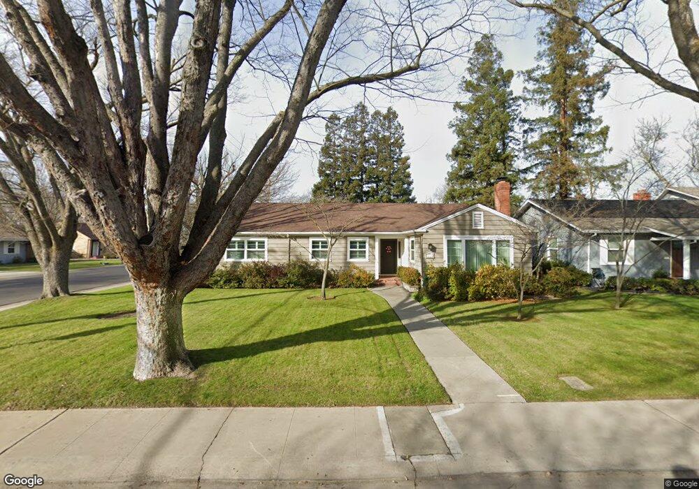
1873 W Euclid Ave Stockton, CA 95204
Country Club NeighborhoodEstimated Value: $391,000 - $510,638
4
Beds
2
Baths
2,177
Sq Ft
$214/Sq Ft
Est. Value
About This Home
This home is located at 1873 W Euclid Ave, Stockton, CA 95204 and is currently estimated at $466,410, approximately $214 per square foot. 1873 W Euclid Ave is a home located in San Joaquin County with nearby schools including Madison Elementary School, Hoover Elementary School, and Flora Arca Mata.
Ownership History
Date
Name
Owned For
Owner Type
Purchase Details
Closed on
Jul 14, 2025
Sold by
Barnes Christine C
Bought by
2014 Scott K Barnes And Christine C Barnes Re and Barnes
Current Estimated Value
Purchase Details
Closed on
Jun 5, 2023
Sold by
Department Of Veterans Affairs Of The St
Bought by
Barnes Scott K and Barnes Christine C
Purchase Details
Closed on
Jan 27, 2014
Sold by
Barnes Scott K and Barnes Christine C
Bought by
The 2014 Scott K Barnes & Christine C Ba and Barnes Christine C
Create a Home Valuation Report for This Property
The Home Valuation Report is an in-depth analysis detailing your home's value as well as a comparison with similar homes in the area
Home Values in the Area
Average Home Value in this Area
Purchase History
| Date | Buyer | Sale Price | Title Company |
|---|---|---|---|
| 2014 Scott K Barnes And Christine C Barnes Re | -- | None Listed On Document | |
| Barnes Scott K | -- | None Listed On Document | |
| The 2014 Scott K Barnes & Christine C Ba | -- | None Available |
Source: Public Records
Tax History Compared to Growth
Tax History
| Year | Tax Paid | Tax Assessment Tax Assessment Total Assessment is a certain percentage of the fair market value that is determined by local assessors to be the total taxable value of land and additions on the property. | Land | Improvement |
|---|---|---|---|---|
| 2025 | $2,848 | $211,268 | $42,251 | $169,017 |
| 2024 | $2,800 | $207,126 | $41,423 | $165,703 |
| 2023 | $2,740 | $203,065 | $40,611 | $162,454 |
| 2022 | $2,686 | $199,084 | $39,815 | $159,269 |
| 2021 | $2,596 | $195,182 | $39,035 | $156,147 |
| 2020 | $2,639 | $193,181 | $38,635 | $154,546 |
| 2019 | $2,627 | $189,394 | $37,878 | $151,516 |
| 2018 | $2,580 | $185,682 | $37,136 | $148,546 |
| 2017 | $2,454 | $182,042 | $36,408 | $145,634 |
| 2016 | $2,491 | $178,473 | $35,695 | $142,778 |
| 2015 | $2,488 | $175,793 | $35,159 | $140,634 |
| 2014 | $2,377 | $172,350 | $34,470 | $137,880 |
Source: Public Records
Map
Nearby Homes
- 4424 Ijams Lot 2 Rd
- 4424 Ijams Lot 3 Rd
- 1750 W Alpine Ave
- 3555 Grange Ave
- 1854 de Ovan Ave
- 1618 Princeton Ave
- 1812 W Monterey Ave
- 2071 W Sonoma Ave
- 1825 Michigan Ave
- 1763 Michigan Ave
- 1605 W Mendocino Ave
- 1944 La Jolla Dr
- 1533 Christina Ave
- 2036 La Jolla Dr
- 2079 Del Rio Dr
- 1517 Christina Ave
- 1705 Bristol Ave
- 3833 Stepping Stone Way
- 1420 Princeton Ave
- 3015 Franklin Ave
- 1869 W Euclid Ave
- 3419 Mission Rd
- 1880 Princeton Ave
- 3409 Mission Rd
- 1868 Princeton Ave
- 3348 Mission Rd
- 3431 Mission Rd
- 3441 Mission Rd
- 1841 W Euclid Ave
- 1870 W Euclid Ave
- 3341 Mission Rd
- 1921 W Euclid Ave
- 1856 Princeton Ave
- 3336 Mission Rd
- 1920 Princeton Ave
- 625 E S Fresno St
- 1972 Del W E Ellis St
- 15 Atherton Dr
- 1860 W Euclid Ave
- 1842 Princeton Ave