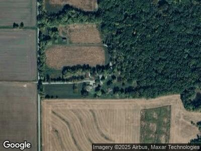
18730 Burnside Rd Carlyle, IL 62231
Estimated Value: $200,000 - $305,000
3
Beds
2
Baths
1,272
Sq Ft
$210/Sq Ft
Est. Value
About This Home
This home is located at 18730 Burnside Rd, Carlyle, IL 62231 and is currently estimated at $266,854, approximately $209 per square foot. 18730 Burnside Rd is a home located in Clinton County with nearby schools including Carlyle Elementary School, Carlyle Junior High School, and Carlyle High School.
Ownership History
Date
Name
Owned For
Owner Type
Purchase Details
Closed on
Nov 27, 2019
Sold by
Sloger Robert L
Bought by
Hitpas Seth M and Hitpas Jessica L
Current Estimated Value
Home Financials for this Owner
Home Financials are based on the most recent Mortgage that was taken out on this home.
Original Mortgage
$175,750
Outstanding Balance
$157,260
Interest Rate
3.6%
Mortgage Type
New Conventional
Estimated Equity
$117,586
Create a Home Valuation Report for This Property
The Home Valuation Report is an in-depth analysis detailing your home's value as well as a comparison with similar homes in the area
Home Values in the Area
Average Home Value in this Area
Purchase History
| Date | Buyer | Sale Price | Title Company |
|---|---|---|---|
| Hitpas Seth M | $185,000 | None Available |
Source: Public Records
Mortgage History
| Date | Status | Borrower | Loan Amount |
|---|---|---|---|
| Open | Hitpas Seth M | $175,750 | |
| Previous Owner | Sloger Robert | $101,500 |
Source: Public Records
Tax History Compared to Growth
Tax History
| Year | Tax Paid | Tax Assessment Tax Assessment Total Assessment is a certain percentage of the fair market value that is determined by local assessors to be the total taxable value of land and additions on the property. | Land | Improvement |
|---|---|---|---|---|
| 2023 | $3,206 | $60,700 | $18,730 | $41,970 |
| 2022 | $3,206 | $61,750 | $21,240 | $40,510 |
| 2021 | $3,106 | $57,710 | $19,850 | $37,860 |
| 2020 | $2,964 | $54,450 | $18,730 | $35,720 |
| 2019 | $1,735 | $54,450 | $18,730 | $35,720 |
| 2018 | $1,810 | $44,370 | $12,840 | $31,530 |
| 2017 | $1,803 | $44,370 | $12,840 | $31,530 |
| 2016 | $0 | $0 | $0 | $0 |
Source: Public Records
Map
Nearby Homes
- 21655 Westview Rd
- 19580 Hillcrest Rd
- 19617 Pam Ln
- 19770 Oak Dr
- 19508 Timber Ln
- 21709 Oriole Ln
- 19856 Cruiser Dr
- 19983 Oak Dr
- 21839 Dove Ln
- 169 Bunny Trail
- 146 Bunny Trail
- 21510 Keyesport Rd
- 0 Oak St Unit MAR25001352
- 710 Clinton St
- 3 Lakeview Dr
- 2 S Circle Dr
- 27 Harbor Dr
- 0 Harbor Dr Lake View
- 15919 Candy Corner Ln
- 10 Mallard Dr
- 18730 Burnside Rd
- 18730 Burnside Rd
- 18724 Burnside Rd
- 18822 Burnside Rd
- 21380 Skelton Rd
- 21275 Skelton Rd
- xxxx Burnside Rd
- xxx Burnside Rd
- 19020 Burnside Rd
- 18500 Burnside Rd
- 21385 Skelton Rd
- 18512 Burnside Rd
- 19095 Edsel Dr
- 18508 Burnside Rd
- 19132 Burnside Rd
- 19136 Burnside Rd
- 19210 Burnside Rd
- 0 Burnside Rd Unit 23029999
- 0 Burnside Rd Unit 22031813
- 19212 Burnside Rd
