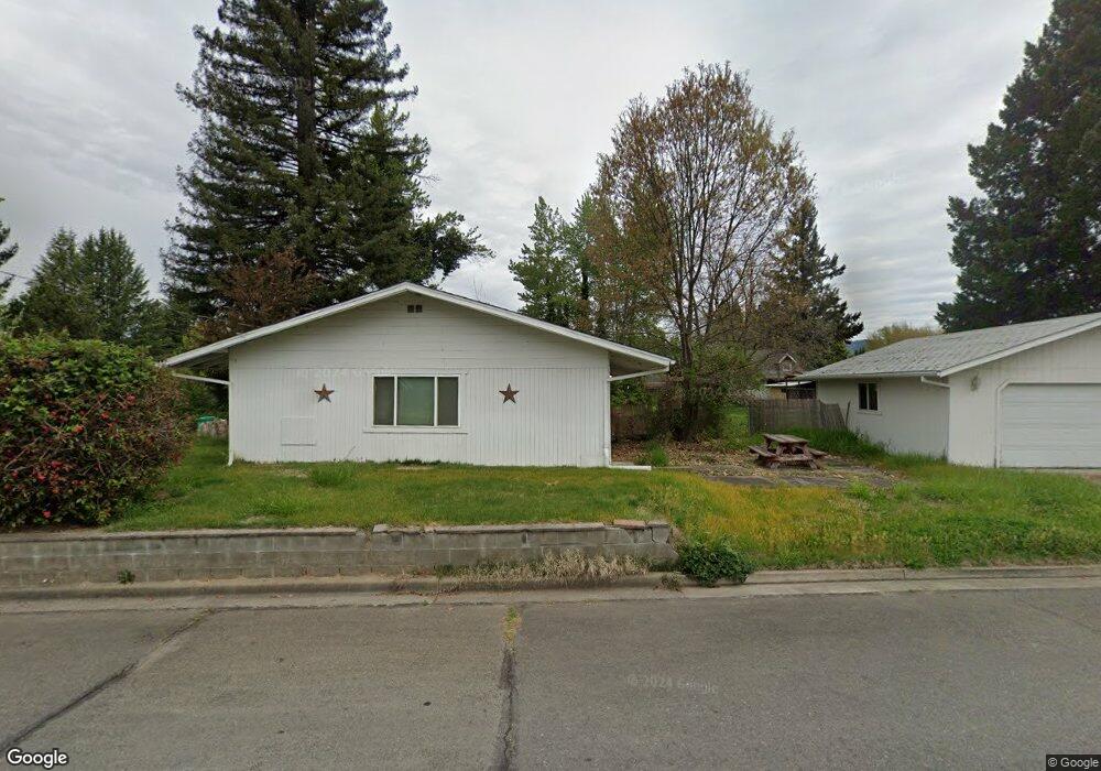
1881 Nebraska Ave Grants Pass, OR 97527
Estimated Value: $303,000 - $342,386
3
Beds
2
Baths
1,456
Sq Ft
$222/Sq Ft
Est. Value
About This Home
This home is located at 1881 Nebraska Ave, Grants Pass, OR 97527 and is currently estimated at $322,693, approximately $221 per square foot. 1881 Nebraska Ave is a home located in Josephine County with nearby schools including Allen Dale Elementary School, South Middle School, and Grants Pass High School.
Ownership History
Date
Name
Owned For
Owner Type
Purchase Details
Closed on
May 8, 2021
Sold by
Anne Zimmermann N and Anne Margarethe B
Bought by
Reedy Amber S
Current Estimated Value
Home Financials for this Owner
Home Financials are based on the most recent Mortgage that was taken out on this home.
Original Mortgage
$266,680
Outstanding Balance
$241,164
Interest Rate
3.1%
Mortgage Type
FHA
Estimated Equity
$81,529
Create a Home Valuation Report for This Property
The Home Valuation Report is an in-depth analysis detailing your home's value as well as a comparison with similar homes in the area
Home Values in the Area
Average Home Value in this Area
Purchase History
| Date | Buyer | Sale Price | Title Company |
|---|---|---|---|
| Reedy Amber S | $271,600 | First American |
Source: Public Records
Mortgage History
| Date | Status | Borrower | Loan Amount |
|---|---|---|---|
| Open | Reedy Amber S | $266,680 |
Source: Public Records
Tax History Compared to Growth
Tax History
| Year | Tax Paid | Tax Assessment Tax Assessment Total Assessment is a certain percentage of the fair market value that is determined by local assessors to be the total taxable value of land and additions on the property. | Land | Improvement |
|---|---|---|---|---|
| 2025 | $2,059 | $158,560 | -- | -- |
| 2024 | $2,059 | $153,950 | -- | -- |
| 2023 | $1,939 | $149,470 | $0 | $0 |
| 2022 | $1,949 | $145,120 | -- | -- |
| 2021 | $1,830 | $140,900 | $0 | $0 |
| 2020 | $1,778 | $136,800 | $0 | $0 |
| 2019 | $1,726 | $132,820 | $0 | $0 |
| 2018 | $1,757 | $128,960 | $0 | $0 |
| 2017 | $1,744 | $125,210 | $0 | $0 |
| 2016 | $1,533 | $121,570 | $0 | $0 |
| 2015 | $1,474 | $118,030 | $0 | $0 |
| 2014 | $1,442 | $114,600 | $0 | $0 |
Source: Public Records
Map
Nearby Homes
- 855 SW West Harbeck Rd
- 1010 Hemlock Ln
- 1048 W Harbeck Rd
- 0 Ramsey Southwest Ave SW Unit 220201654
- 1969 SW Allen Creek Rd
- 1830 SW Allen Creek Rd
- 1762 SW Allen Creek Rd
- 681 W Harbeck Rd
- 109 Shoemaker Way
- 1346 Sunny Slope Dr
- 1318 Andy Griffith Dr
- 1382 Andy Griffith Dr
- 1439 Daisy Ln
- 426 SE Cadet Ct
- 2957 Sylvan Dr
- 15577 Oregon 238
- 1444 Barney Fife Blvd
- 0 Sylvan Dr Unit Lot 10 220196204
- 444 Union Ave Unit TL 1700
- 444 Union Ave Unit TL 1600
- 1980 McCarter Ln
- 2023 McCarter Ln
- 1918 McCarter Ln
- 2017 McCarter Ln
- 1887 Nebraska Ave
- 1817 SW Nebraska Ave
- 1962 McCarter Ln
- 1985 McCarter Ln
- 1001 Aspen Way
- 1862 Tamarac Ln
- 1906 McCarter Ln
- 1912 McCarter Ln
- 1979 McCarter Ln
- 1854 Tamarac Ln
- 1910 Colorado Ln
- 1016 Omaha Dr
- 1013 Aspen Way
- 1903 Nebraska Ave
- 1901 Colorado Ln
- 1894 McCarter Ln