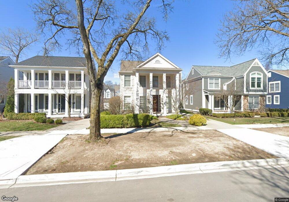
1882 Pierce St Unit Bldg-Unit Birmingham, MI 48009
Estimated Value: $814,000 - $990,000
3
Beds
3
Baths
2,336
Sq Ft
$391/Sq Ft
Est. Value
About This Home
This home is located at 1882 Pierce St Unit Bldg-Unit, Birmingham, MI 48009 and is currently estimated at $914,412, approximately $391 per square foot. 1882 Pierce St Unit Bldg-Unit is a home located in Oakland County with nearby schools including Pierce Elementary School, Derby Middle School, and Ernest W. Seaholm High School.
Ownership History
Date
Name
Owned For
Owner Type
Purchase Details
Closed on
May 13, 2021
Sold by
Murdock Steven E and Steven E Murdock Trust
Bought by
Nauer Christopher M and Miller Nicole A
Current Estimated Value
Purchase Details
Closed on
Mar 9, 2006
Sold by
Murdock Steven E
Bought by
Murdock Steven E and Steven E Murdock Trust
Purchase Details
Closed on
Aug 27, 2004
Sold by
Robertson Intown Llc
Bought by
Murdock Steven F
Purchase Details
Closed on
May 20, 2004
Sold by
Robertson Brothers Co
Bought by
Robertson In Town Llc
Purchase Details
Closed on
May 27, 2003
Sold by
School District Of The City Of Birmingha
Bought by
Robertson Brothers Co
Create a Home Valuation Report for This Property
The Home Valuation Report is an in-depth analysis detailing your home's value as well as a comparison with similar homes in the area
Home Values in the Area
Average Home Value in this Area
Purchase History
| Date | Buyer | Sale Price | Title Company |
|---|---|---|---|
| Nauer Christopher M | $655,000 | Capital Title Ins Agcy Inc | |
| Murdock Steven E | -- | None Available | |
| Murdock Steven F | -- | Metropolitan Title Company | |
| Robertson In Town Llc | -- | Metropolitan | |
| Robertson Brothers Co | -- | -- |
Source: Public Records
Tax History Compared to Growth
Tax History
| Year | Tax Paid | Tax Assessment Tax Assessment Total Assessment is a certain percentage of the fair market value that is determined by local assessors to be the total taxable value of land and additions on the property. | Land | Improvement |
|---|---|---|---|---|
| 2024 | $12,712 | $385,780 | $0 | $0 |
| 2023 | $12,181 | $363,030 | $0 | $0 |
| 2022 | $13,061 | $338,530 | $0 | $0 |
| 2021 | $9,983 | $327,960 | $0 | $0 |
| 2020 | $8,895 | $328,120 | $0 | $0 |
| 2019 | $10,066 | $317,910 | $0 | $0 |
| 2018 | $9,989 | $306,490 | $0 | $0 |
| 2017 | $9,972 | $305,320 | $0 | $0 |
| 2016 | $9,990 | $304,680 | $0 | $0 |
| 2015 | -- | $290,270 | $0 | $0 |
| 2014 | -- | $263,560 | $0 | $0 |
| 2011 | -- | $209,430 | $0 | $0 |
Source: Public Records
Map
Nearby Homes
- 1886 Henrietta St
- 150 Bird Ave Unit 20
- 1978 Henrietta St
- 251 E 14 Mile Rd
- 16975 W Fourteen Mile Rd
- 16991 Kirkshire Ave
- 350 Catalpa Dr
- 1748 Stanley Blvd
- 16281 Buckingham Ave
- 1419 Henrietta St
- 15858 Kirkshire Ave
- 1626 Maryland Blvd
- 1723 Birmingham Blvd
- 1323 Washington Blvd
- 16950 Kinross Ave
- 1205 S Bates St
- 15654 Kirkshire Ave
- 1850 Shipman Blvd
- 1992 Shipman Blvd
- 1541 Shipman Blvd
- 1882 Pierce St
- 1896 Pierce St
- 1866 Pierce St
- 1990 Pierce St
- 1848 Pierce St
- 1885 Henrietta St
- 1859 Henrietta St
- 1826 Pierce St
- 1919 Henrietta St
- 1841 Henrietta St
- 1943 Henrietta St
- 1806 Pierce St
- 1825 Henrietta St
- 1807 Henrietta St
- 1788 Pierce St
- 158 W 14 Mile Rd
- 106 W 14 Mile Rd
- 152 W 14 Mile Rd
- 1975 Henrietta St
- 1787 Henrietta St