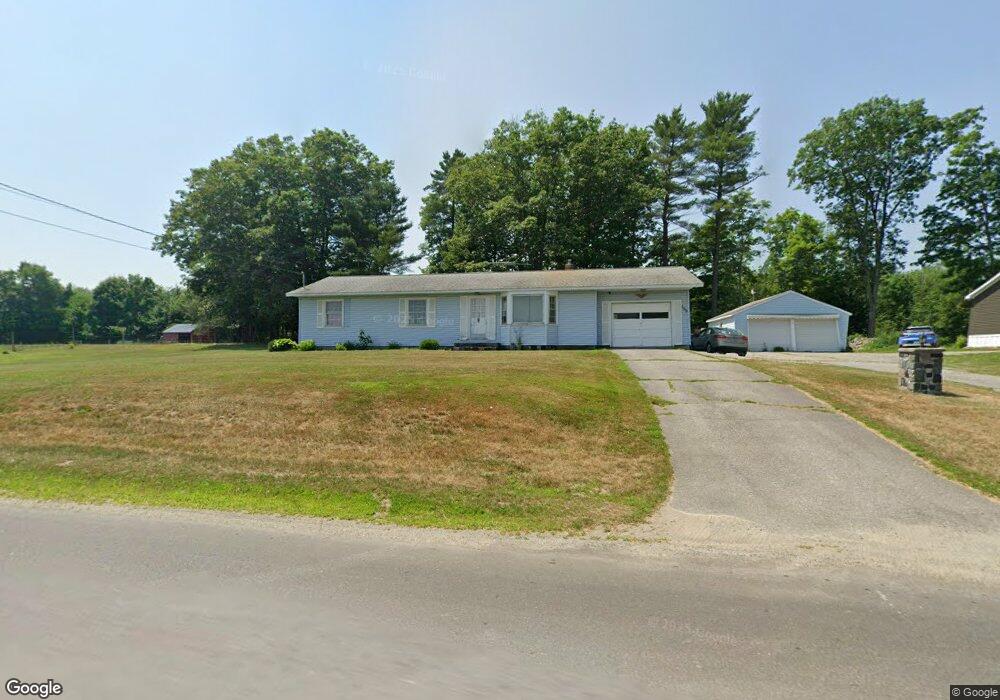
189 Hussey Rd Albion, ME 04910
Estimated Value: $313,000 - $472,000
--
Bed
--
Bath
--
Sq Ft
69
Acres
About This Home
This home is located at 189 Hussey Rd, Albion, ME 04910 and is currently estimated at $395,568. 189 Hussey Rd is a home with nearby schools including Lawrence High School.
Ownership History
Date
Name
Owned For
Owner Type
Purchase Details
Closed on
Nov 26, 2019
Sold by
Sawtelle Kathryn K
Bought by
Sawtelle Thomas
Current Estimated Value
Home Financials for this Owner
Home Financials are based on the most recent Mortgage that was taken out on this home.
Original Mortgage
$184,380
Outstanding Balance
$162,181
Interest Rate
3.7%
Mortgage Type
VA
Estimated Equity
$233,387
Create a Home Valuation Report for This Property
The Home Valuation Report is an in-depth analysis detailing your home's value as well as a comparison with similar homes in the area
Home Values in the Area
Average Home Value in this Area
Purchase History
| Date | Buyer | Sale Price | Title Company |
|---|---|---|---|
| Sawtelle Thomas | -- | None Available | |
| Sawtelle Thomas | -- | None Available | |
| Sawtelle Thomas | -- | None Available |
Source: Public Records
Mortgage History
| Date | Status | Borrower | Loan Amount |
|---|---|---|---|
| Open | Sawtelle Thomas | $184,380 | |
| Closed | Sawtelle Thomas | $184,380 |
Source: Public Records
Tax History Compared to Growth
Tax History
| Year | Tax Paid | Tax Assessment Tax Assessment Total Assessment is a certain percentage of the fair market value that is determined by local assessors to be the total taxable value of land and additions on the property. | Land | Improvement |
|---|---|---|---|---|
| 2024 | $3,667 | $234,300 | $51,500 | $182,800 |
| 2023 | $3,336 | $234,100 | $51,300 | $182,800 |
| 2022 | $2,975 | $179,200 | $40,700 | $138,500 |
| 2021 | $3,571 | $202,900 | $64,400 | $138,500 |
| 2020 | $3,561 | $202,900 | $64,400 | $138,500 |
| 2019 | $3,378 | $202,900 | $64,400 | $138,500 |
| 2018 | $3,307 | $202,900 | $64,400 | $138,500 |
| 2017 | $3,517 | $219,800 | $81,300 | $138,500 |
| 2016 | $3,462 | $219,800 | $81,300 | $138,500 |
| 2015 | $3,407 | $219,800 | $81,300 | $138,500 |
| 2014 | $3,297 | $219,800 | $81,300 | $138,500 |
| 2013 | $3,212 | $221,500 | $81,300 | $140,200 |
Source: Public Records
Map
Nearby Homes
- 17 Main St
- 26 Unity Rd
- 45 Marden Shore Rd
- 118 Marden Shore Rd
- 253 Benton Rd
- 61 Pond Rd
- Lot #58 S Vigue Shore Rd
- TBD Pond Rd
- M5 L27-3 Marks Rd
- 88 Drake Hill Rd
- 773 China Rd
- 35 Abbott Rd
- 60 Danforth Rd
- 257 Pleasant View Ridge Rd
- 187 Richards Rd
- 498 Morrill Rd
- 12 Country View Ln
- 68 Parmenter Terrace
- Lot 10 Maine 137
- 230 Beaver Ridge Rd