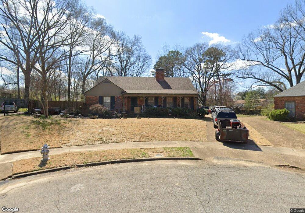
189 Lorece Ln Memphis, TN 38117
Audubon Park NeighborhoodEstimated Value: $381,000 - $396,893
3
Beds
3
Baths
2,372
Sq Ft
$164/Sq Ft
Est. Value
About This Home
This home is located at 189 Lorece Ln, Memphis, TN 38117 and is currently estimated at $388,473, approximately $163 per square foot. 189 Lorece Ln is a home located in Shelby County with nearby schools including White Station Elementary School, White Station Middle, and White Station High.
Ownership History
Date
Name
Owned For
Owner Type
Purchase Details
Closed on
Feb 16, 2007
Sold by
Jorgensen J Michael and Anderson Sally J
Bought by
Delany Jason and Delany Melissa W
Current Estimated Value
Home Financials for this Owner
Home Financials are based on the most recent Mortgage that was taken out on this home.
Original Mortgage
$167,200
Outstanding Balance
$100,201
Interest Rate
6.17%
Mortgage Type
Purchase Money Mortgage
Estimated Equity
$288,272
Create a Home Valuation Report for This Property
The Home Valuation Report is an in-depth analysis detailing your home's value as well as a comparison with similar homes in the area
Home Values in the Area
Average Home Value in this Area
Purchase History
| Date | Buyer | Sale Price | Title Company |
|---|---|---|---|
| Delany Jason | $209,000 | Realty Title |
Source: Public Records
Mortgage History
| Date | Status | Borrower | Loan Amount |
|---|---|---|---|
| Open | Delany Jason | $167,200 |
Source: Public Records
Tax History Compared to Growth
Tax History
| Year | Tax Paid | Tax Assessment Tax Assessment Total Assessment is a certain percentage of the fair market value that is determined by local assessors to be the total taxable value of land and additions on the property. | Land | Improvement |
|---|---|---|---|---|
| 2025 | $2,603 | $94,200 | $31,175 | $63,025 |
| 2024 | $2,603 | $76,775 | $31,175 | $45,600 |
| 2023 | $4,677 | $76,775 | $31,175 | $45,600 |
| 2022 | $4,677 | $76,775 | $31,175 | $45,600 |
| 2021 | $4,732 | $76,775 | $31,175 | $45,600 |
| 2020 | $4,556 | $62,875 | $31,175 | $31,700 |
| 2019 | $4,556 | $62,875 | $31,175 | $31,700 |
| 2018 | $4,556 | $62,875 | $31,175 | $31,700 |
| 2017 | $2,584 | $62,875 | $31,175 | $31,700 |
| 2016 | $2,586 | $59,175 | $0 | $0 |
| 2014 | $2,586 | $59,175 | $0 | $0 |
Source: Public Records
Map
Nearby Homes
- 4798 Normandy Ln
- 131 N Mendenhall Rd
- 4723 Normandy Ln
- 4956 Robindale Ln
- 4980 Barfield Rd
- 352 Avon Rd
- 4985 Chickasaw Rd
- 4737 Sequoia Rd
- 4975 Brookwood Cove
- 4730 Sequoia Rd
- 209 Leonora Dr
- 4640 Chickasaw Rd
- 416 Elwood Ln
- 4679 Walnut Grove Rd
- 5081 Rich Rd
- 5103 Norich Ave
- 4865 Princeton Rd
- 5068 Walnut Grove Rd
- 202 Betty jo Ln
- 346 Leonora Dr
- 193 Lorece Ln
- 192 Lorece Ln
- 199 Lorece Ln
- 4820 Barfield Rd
- 4826 Barfield Rd
- 196 Lorece Ln
- 4838 Barfield Rd
- 178 Avon Rd
- 4855 Mendenhall Place
- 186 Avon Rd
- 204 Lorece Ln
- 207 Lorece Ln
- 4810 Barfield Rd
- 4861 Mendenhall Place
- 196 Avon Rd
- 4860 Mendenhall Place
- 210 Lorece Ln
- 4800 Barfield Rd
- 4850 Barfield Rd
- 200 Avon Rd