Estimated Value: $393,000 - $475,000
3
Beds
3
Baths
1,861
Sq Ft
$229/Sq Ft
Est. Value
About This Home
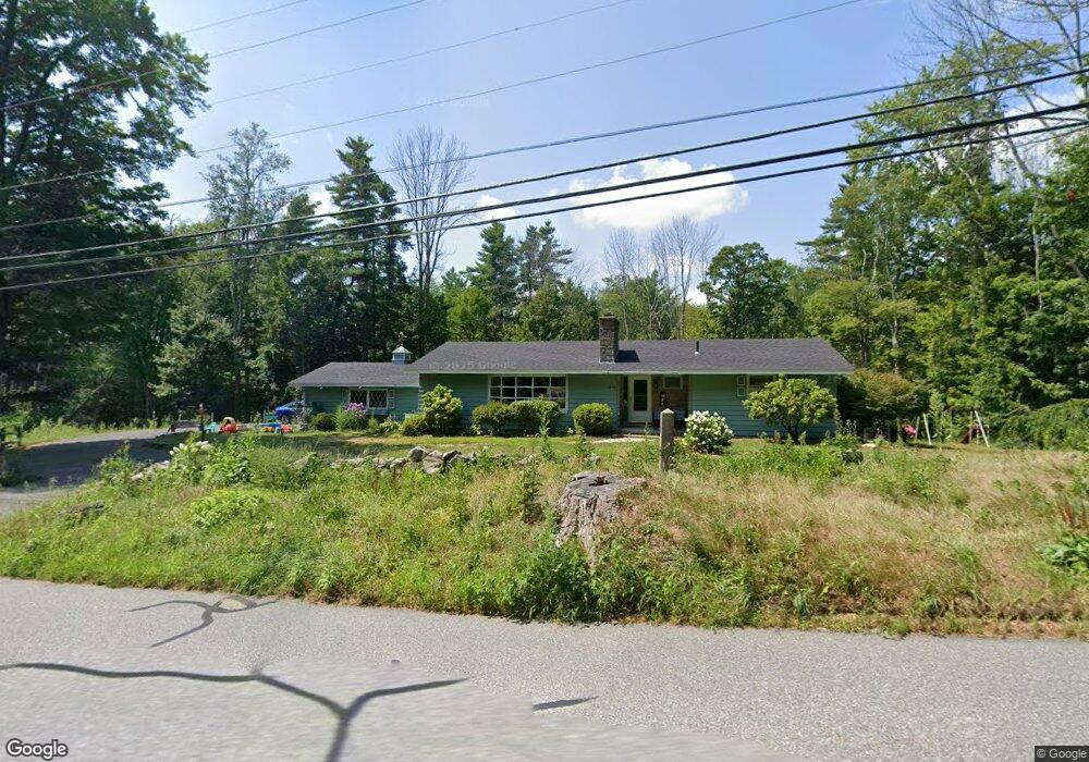
This home is located at 1890 Chestnut Hill Ave, Athol, MA 01331 and is currently estimated at $425,401, approximately $228 per square foot. 1890 Chestnut Hill Ave is a home located in Worcester County with nearby schools including Athol High School.
Ownership History
Date
Name
Owned For
Owner Type
Purchase Details
Closed on
Jan 15, 2015
Sold by
Es Higgins Elizabeth J
Bought by
May Scott D and May Joslyn D
Current Estimated Value
Home Financials for this Owner
Home Financials are based on the most recent Mortgage that was taken out on this home.
Original Mortgage
$188,977
Outstanding Balance
$145,174
Interest Rate
3.92%
Mortgage Type
VA
Estimated Equity
$280,227
Create a Home Valuation Report for This Property
The Home Valuation Report is an in-depth analysis detailing your home's value as well as a comparison with similar homes in the area
Home Values in the Area
Average Home Value in this Area
Purchase History
| Date | Buyer | Sale Price | Title Company |
|---|---|---|---|
| May Scott D | $185,000 | -- |
Source: Public Records
Mortgage History
| Date | Status | Borrower | Loan Amount |
|---|---|---|---|
| Open | May Scott D | $188,977 |
Source: Public Records
Tax History Compared to Growth
Tax History
| Year | Tax Paid | Tax Assessment Tax Assessment Total Assessment is a certain percentage of the fair market value that is determined by local assessors to be the total taxable value of land and additions on the property. | Land | Improvement |
|---|---|---|---|---|
| 2025 | $4,449 | $350,000 | $93,400 | $256,600 |
| 2024 | $4,355 | $339,400 | $90,300 | $249,100 |
| 2023 | $4,178 | $297,600 | $68,500 | $229,100 |
| 2022 | $4,091 | $254,900 | $65,800 | $189,100 |
| 2021 | $3,982 | $225,500 | $59,900 | $165,600 |
| 2020 | $293 | $223,200 | $55,500 | $167,700 |
| 2019 | $3,698 | $211,900 | $52,300 | $159,600 |
| 2018 | $3,765 | $192,400 | $46,900 | $145,500 |
| 2017 | $3,474 | $170,300 | $46,900 | $123,400 |
| 2016 | $3,552 | $179,100 | $46,900 | $132,200 |
| 2015 | $3,408 | $179,100 | $46,900 | $132,200 |
| 2014 | $3,301 | $179,100 | $46,900 | $132,200 |
Source: Public Records
Map
Nearby Homes
- 77 Old Keene Rd
- 0 W Royalston Rd
- 2978 Chestnut Hill Ave
- 0 Adams Dr
- 87 Bellevue Dr E
- 15 Wilson Ave
- 3327 Chestnut Hill Ave
- 220 Orange St
- 520 Lenox St
- 31 Locke Ave
- 31 Pinedale Rd
- 1179 Main St
- 133 Green St Unit 3
- 72 Green St
- 503 School St
- 660 Pinedale Ave
- 124 Fish St
- 15 Tully Rd
- 2791 Old Keene Rd
- 22 Allen St
- 1920 Chestnut Hill Ave
- 1952 Chestnut Hill Ave
- 1978 Chestnut Hill Ave
- 1777 Chestnut Hill Ave
- 1939 Chestnut Hill Ave
- 2086 Chestnut Hill Ave
- Lot B Chestnut Hill Ave
- 1676 Chestnut Hill Ave
- 2117 Chestnut Hill Ave
- 2157 Chestnut Hill Ave
- 119 Townsend Rd
- 586 Townsend Rd
- 2239 Chestnut Hill Ave
- 1473 Chestnut Hill Ave
- 1354 Chestnut Hill Ave
- 1390 Chestnut Hill Ave
- 2351 Chestnut Hill Ave
- 2386 Chestnut Hill Ave
- 2414 Chestnut Hill Ave
- 41 Gulf Rd