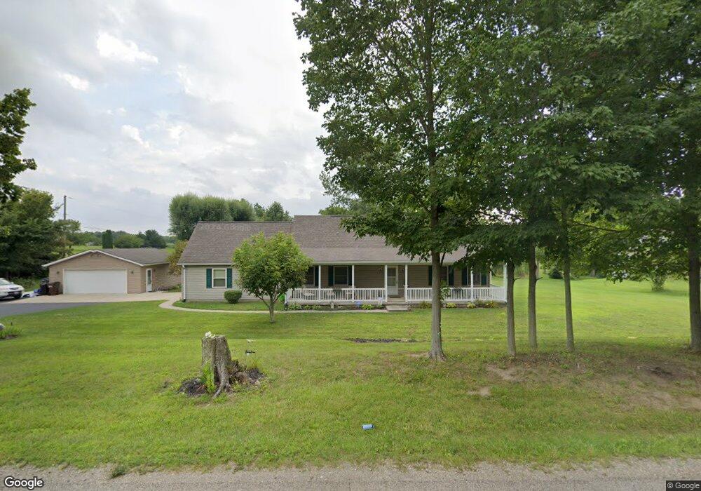
1891 S Tecumseh Rd Springfield, OH 45502
Estimated Value: $269,000 - $345,000
2
Beds
2
Baths
1,555
Sq Ft
$195/Sq Ft
Est. Value
About This Home
This home is located at 1891 S Tecumseh Rd, Springfield, OH 45502 and is currently estimated at $302,751, approximately $194 per square foot. 1891 S Tecumseh Rd is a home located in Clark County with nearby schools including Greenon Elementary School, Greenon Jr. High School, and Greenon High School.
Ownership History
Date
Name
Owned For
Owner Type
Purchase Details
Closed on
Oct 2, 2017
Sold by
Miller Karl B and Adams Kelly R
Bought by
Miller Karl B and Adams Kelly R
Current Estimated Value
Home Financials for this Owner
Home Financials are based on the most recent Mortgage that was taken out on this home.
Original Mortgage
$180,000
Interest Rate
3.78%
Mortgage Type
VA
Purchase Details
Closed on
May 9, 1996
Sold by
Scott Burley E
Bought by
Miller Paul F and Miller Karla B
Create a Home Valuation Report for This Property
The Home Valuation Report is an in-depth analysis detailing your home's value as well as a comparison with similar homes in the area
Purchase History
| Date | Buyer | Sale Price | Title Company |
|---|---|---|---|
| Miller Karl B | -- | Old Republic Title | |
| Miller Paul F | $17,900 | -- |
Source: Public Records
Mortgage History
| Date | Status | Borrower | Loan Amount |
|---|---|---|---|
| Previous Owner | Miller Karl B | $180,000 |
Source: Public Records
Tax History
| Year | Tax Paid | Tax Assessment Tax Assessment Total Assessment is a certain percentage of the fair market value that is determined by local assessors to be the total taxable value of land and additions on the property. | Land | Improvement |
|---|---|---|---|---|
| 2025 | $4,687 | $106,760 | $20,060 | $86,700 |
| 2024 | $4,577 | $87,310 | $19,130 | $68,180 |
| 2023 | $4,577 | $87,310 | $19,130 | $68,180 |
| 2022 | $4,572 | $87,310 | $19,130 | $68,180 |
| 2021 | $3,825 | $64,730 | $13,860 | $50,870 |
| 2020 | $3,835 | $64,730 | $13,860 | $50,870 |
| 2019 | $3,887 | $64,730 | $13,860 | $50,870 |
| 2018 | $3,615 | $58,840 | $12,710 | $46,130 |
| 2017 | $3,691 | $58,839 | $12,705 | $46,134 |
| 2016 | $3,227 | $58,839 | $12,705 | $46,134 |
| 2015 | $2,965 | $52,129 | $11,550 | $40,579 |
| 2014 | $2,971 | $52,129 | $11,550 | $40,579 |
| 2013 | $2,622 | $52,129 | $11,550 | $40,579 |
Source: Public Records
Map
Nearby Homes
- 3183 Lower Valley Pike
- 2925 S Tecumseh Rd
- 206 S Tecumseh Rd
- 100 Green Valley Dr
- 303 E Main St
- 3434 Killdeer Dr
- 128 Ravenwood Dr
- 141 N Xenia Dr
- 3190 Rebert Pike
- 4909 Shannon Ave
- 1513 Ridgeway Dr
- 169 E Main St
- 3319 Wendover St
- 4461 New Carlisle Pike
- 3924 Schenley St
- 1290 Red Oaks Cir
- 3267 Lower Valley Pike Unit Tract 2
- 3864 Quailhollow Ct
- 22 W Main St
- 80 Carlisle Ave
- 1857 S Tecumseh Rd
- 1924 S Tecumseh Rd
- 1825 S Tecumseh Rd
- 1822 S Tecumseh Rd
- 1925 S Tecumseh Rd
- 1945 S Tecumseh Rd
- 1862 S Tecumseh Rd
- 1743 S Tecumseh Rd
- 1984 S Tecumseh Rd
- 1985 S Tecumseh Rd
- 2000 S Tecumseh Rd
- 1980 Snyderville Rd
- 5411 Harshman Rd
- 2041 S Tecumseh Rd
- 2030 S Tecumseh Rd
- 1794 Snyderville Rd
- 1661 S Tecumseh Rd
- 2050 S Tecumseh Rd
- 2040 Snyderville Rd
- 1833 Snyderville Rd
Your Personal Tour Guide
Ask me questions while you tour the home.