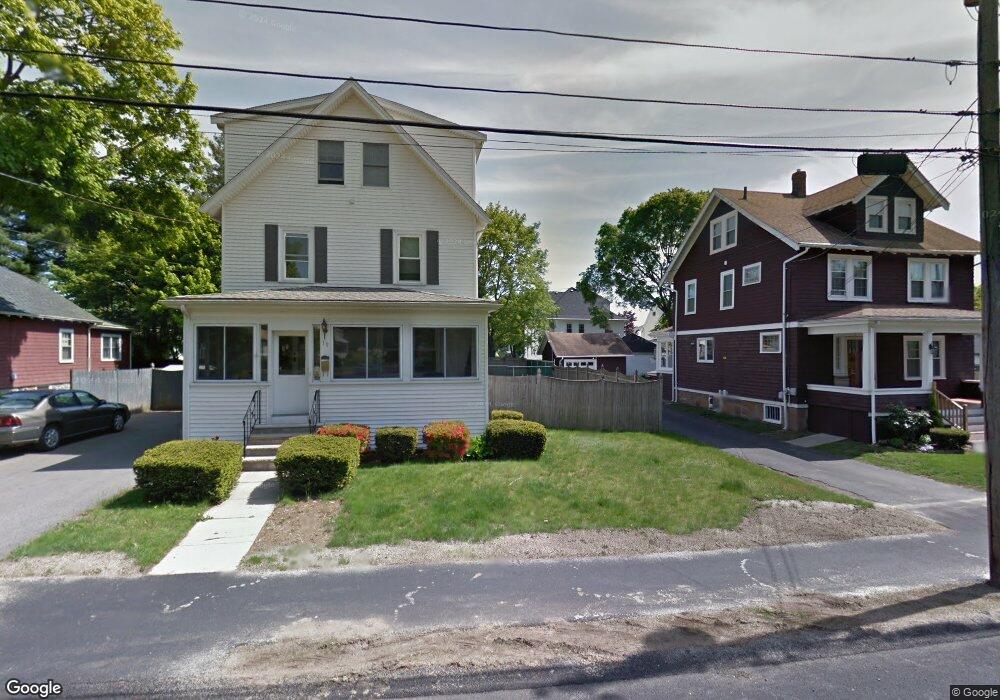
19 Azel Rd Braintree, MA 02184
North Braintree NeighborhoodEstimated Value: $748,000 - $861,000
5
Beds
2
Baths
2,170
Sq Ft
$366/Sq Ft
Est. Value
About This Home
This home is located at 19 Azel Rd, Braintree, MA 02184 and is currently estimated at $794,975, approximately $366 per square foot. 19 Azel Rd is a home located in Norfolk County with nearby schools including Braintree High School, Step Ahead Kindergarten, and Meeting House Montessori School.
Ownership History
Date
Name
Owned For
Owner Type
Purchase Details
Closed on
Mar 23, 2022
Sold by
Murphy Francis L and Murphy Denise B
Bought by
Murphy Rt
Current Estimated Value
Purchase Details
Closed on
Jul 1, 1998
Sold by
Arico Ralph J and Arico Cynthia J
Bought by
Murphy Francis L and Murphy Denise B
Create a Home Valuation Report for This Property
The Home Valuation Report is an in-depth analysis detailing your home's value as well as a comparison with similar homes in the area
Home Values in the Area
Average Home Value in this Area
Purchase History
| Date | Buyer | Sale Price | Title Company |
|---|---|---|---|
| Murphy Rt | -- | None Available | |
| Murphy Francis L | $194,500 | -- | |
| Murphy Francis L | $194,500 | -- |
Source: Public Records
Mortgage History
| Date | Status | Borrower | Loan Amount |
|---|---|---|---|
| Previous Owner | Murphy Francis L | $341,000 | |
| Previous Owner | Murphy Francis L | $345,000 |
Source: Public Records
Tax History
| Year | Tax Paid | Tax Assessment Tax Assessment Total Assessment is a certain percentage of the fair market value that is determined by local assessors to be the total taxable value of land and additions on the property. | Land | Improvement |
|---|---|---|---|---|
| 2025 | $6,733 | $674,600 | $340,200 | $334,400 |
| 2024 | $6,152 | $648,900 | $317,200 | $331,700 |
| 2023 | $5,841 | $598,500 | $285,000 | $313,500 |
| 2022 | $5,680 | $570,900 | $257,400 | $313,500 |
| 2021 | $5,164 | $519,000 | $232,600 | $286,400 |
| 2020 | $4,780 | $484,800 | $211,500 | $273,300 |
| 2019 | $4,638 | $459,700 | $202,300 | $257,400 |
| 2018 | $4,541 | $430,800 | $183,900 | $246,900 |
| 2017 | $4,378 | $407,600 | $174,700 | $232,900 |
| 2016 | $4,063 | $370,000 | $147,100 | $222,900 |
| 2015 | $3,989 | $360,300 | $145,300 | $215,000 |
| 2014 | $3,787 | $331,600 | $132,400 | $199,200 |
Source: Public Records
Map
Nearby Homes
- 6 Franklin St
- 18 Royal Lake Dr Unit 3
- 5 Woodsum Dr Unit 12
- 145 Hancock St Unit 307
- 145 Hancock St Unit 201
- 44 Shepard Rd
- 491 Washington St Unit 1
- 418 John Mahar Hwy Unit 408
- 469-471 Washington St
- 422 John Mahar Hwy Unit 408
- 87 Walnut St
- 6 Lunar Ave
- 7 Del's Way
- 426 John Mahar Hwy Unit 311
- 426 John Mahar Hwy Unit 406
- 80 Lake St
- 43 Grove Cir
- 15 Calvin St
- 47 Addison St
- 36 Chestnut Ave
- 15 Azel Rd
- 21 Azel Rd
- 109 Central Ave Unit 111
- 113 Central Ave Unit 115
- 113 Central Ave Unit 2
- 113 Central Ave
- 113 Central Ave
- 115 Central Ave
- 113 Central Ave
- 117 Central Ave Unit 119
- 119 Central Ave Unit 1
- 105 Central Ave
- 16 Azel Rd
- 25 Azel Rd
- 128 Tremont St
- 132 Tremont St
- 121 Central Ave
- 123 Franklin St
- 101 Central Ave
- 29 Azel Rd
Your Personal Tour Guide
Ask me questions while you tour the home.