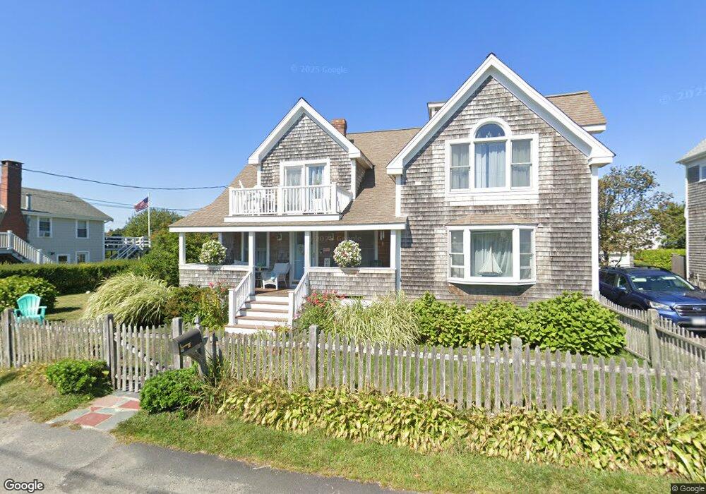
19 Carver Ave Scituate, MA 02066
Estimated Value: $820,000 - $1,232,000
4
Beds
3
Baths
2,571
Sq Ft
$398/Sq Ft
Est. Value
About This Home
This home is located at 19 Carver Ave, Scituate, MA 02066 and is currently estimated at $1,024,173, approximately $398 per square foot. 19 Carver Ave is a home located in Plymouth County with nearby schools including Wampatuck Elementary School, Lester J. Gates Middle School, and Scituate High School.
Ownership History
Date
Name
Owned For
Owner Type
Purchase Details
Closed on
Sep 29, 2000
Sold by
Collins-Roysden Linda
Bought by
Dorgan William J and Baumann Elizabeth A
Current Estimated Value
Purchase Details
Closed on
Jun 2, 1999
Sold by
Oconnor Allyson M
Bought by
Collins-Roysden Linda
Purchase Details
Closed on
May 6, 1998
Sold by
Wall Mary I
Bought by
Oconnor Allyson M
Create a Home Valuation Report for This Property
The Home Valuation Report is an in-depth analysis detailing your home's value as well as a comparison with similar homes in the area
Home Values in the Area
Average Home Value in this Area
Purchase History
| Date | Buyer | Sale Price | Title Company |
|---|---|---|---|
| Dorgan William J | $257,500 | -- | |
| Collins-Roysden Linda | $225,000 | -- | |
| Oconnor Allyson M | $164,000 | -- |
Source: Public Records
Mortgage History
| Date | Status | Borrower | Loan Amount |
|---|---|---|---|
| Open | Oconnor Allyson M | $413,000 | |
| Closed | Oconnor Allyson M | $417,000 |
Source: Public Records
Tax History Compared to Growth
Tax History
| Year | Tax Paid | Tax Assessment Tax Assessment Total Assessment is a certain percentage of the fair market value that is determined by local assessors to be the total taxable value of land and additions on the property. | Land | Improvement |
|---|---|---|---|---|
| 2025 | $9,814 | $982,400 | $476,800 | $505,600 |
| 2024 | $9,702 | $936,500 | $433,400 | $503,100 |
| 2023 | $8,975 | $848,200 | $394,000 | $454,200 |
| 2022 | $8,975 | $711,200 | $330,200 | $381,000 |
| 2021 | $8,571 | $643,000 | $314,500 | $328,500 |
| 2020 | $8,309 | $615,500 | $302,300 | $313,200 |
| 2019 | $8,190 | $596,100 | $296,400 | $299,700 |
| 2018 | $7,988 | $572,600 | $292,000 | $280,600 |
| 2017 | $7,920 | $562,100 | $281,500 | $280,600 |
| 2016 | $7,948 | $562,100 | $281,500 | $280,600 |
| 2015 | $7,227 | $551,700 | $271,100 | $280,600 |
Source: Public Records
Map
Nearby Homes
- 17 Bradford Ave
- 209 Hatherly Rd
- 30 Irving Rd
- 378 Tilden Rd
- 10 Benjamin Ln Unit 10
- 23 Oceanside Dr
- 2 Windward Ln
- 105 Turner Rd
- 22 Kings Way
- 27 Ann Vinal Rd
- 54 Woodland Rd
- 59 Captain Peirce Rd
- 32 Barker Rd Unit 3
- 74 Tilden Rd
- 29 Country Club Cir
- 76 A Brook St
- 76 A Brook St Unit 1
- 112 Hollett St
- 14 Aberdeen Dr
- 3 Grace Way Unit 3
- 23 Carver Ave
- 17 Carver Ave
- 22 Bradford Ave
- 20 Carver Ave
- 24 Bradford Ave
- 15 Seaside Rd
- 15 Carver Ave
- 18 Carver Ave
- 18 Bradford Ave Unit 18
- 9 Seaside Rd
- 17 Seaside Rd
- 16 Carver Ave
- 16 Carver Ave
- 13 Carver Ave
- 25 Bradford Ave
- 25 Standish Ave
- 8 Egypt Ave
- 27 Standish Ave
- 23 Standish Ave
- 21 Bradford Ave