Estimated Value: $983,668 - $1,212,000
4
Beds
3
Baths
2,296
Sq Ft
$481/Sq Ft
Est. Value
About This Home
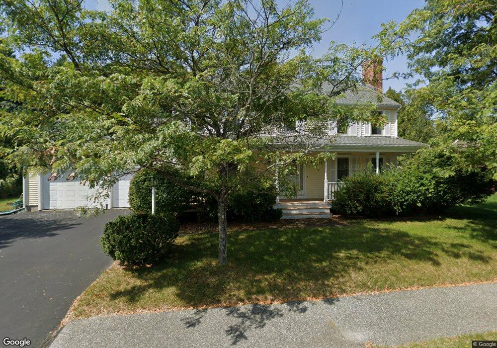
This home is located at 19 Lexington Dr, Acton, MA 01720 and is currently estimated at $1,105,417, approximately $481 per square foot. 19 Lexington Dr is a home located in Middlesex County with nearby schools including Acton-Boxborough Regional High School and Concord Academy.
Ownership History
Date
Name
Owned For
Owner Type
Purchase Details
Closed on
Jun 28, 2007
Sold by
Elliott-Patton Dawn and Patton John E
Bought by
Ma Ling and Cui Yong
Current Estimated Value
Purchase Details
Closed on
Jul 1, 1996
Sold by
Lawsbrook Inc
Bought by
Patton John E
Create a Home Valuation Report for This Property
The Home Valuation Report is an in-depth analysis detailing your home's value as well as a comparison with similar homes in the area
Home Values in the Area
Average Home Value in this Area
Purchase History
| Date | Buyer | Sale Price | Title Company |
|---|---|---|---|
| Ma Ling | $600,000 | -- | |
| Patton John E | $314,000 | -- |
Source: Public Records
Mortgage History
| Date | Status | Borrower | Loan Amount |
|---|---|---|---|
| Open | Patton John E | $230,000 | |
| Closed | Patton John E | $250,000 | |
| Closed | Patton John E | $260,000 | |
| Closed | Patton John E | $280,000 |
Source: Public Records
Tax History Compared to Growth
Tax History
| Year | Tax Paid | Tax Assessment Tax Assessment Total Assessment is a certain percentage of the fair market value that is determined by local assessors to be the total taxable value of land and additions on the property. | Land | Improvement |
|---|---|---|---|---|
| 2025 | $14,758 | $860,500 | $305,200 | $555,300 |
| 2024 | $13,756 | $825,200 | $305,200 | $520,000 |
| 2023 | $13,864 | $789,500 | $277,500 | $512,000 |
| 2022 | $13,098 | $673,400 | $241,300 | $432,100 |
| 2021 | $12,800 | $632,700 | $223,400 | $409,300 |
| 2020 | $12,062 | $626,900 | $223,400 | $403,500 |
| 2019 | $11,574 | $597,500 | $223,400 | $374,100 |
| 2018 | $11,353 | $585,800 | $223,400 | $362,400 |
| 2017 | $11,053 | $579,900 | $223,400 | $356,500 |
| 2016 | $10,813 | $562,300 | $223,400 | $338,900 |
| 2015 | $10,841 | $569,100 | $223,400 | $345,700 |
| 2014 | $10,417 | $535,600 | $223,400 | $312,200 |
Source: Public Records
Map
Nearby Homes
- 65 Summit St
- 2 Clover Hill Rd
- 118 Parker St Unit 16
- 128 Parker St Unit 3B
- 70 Hillside Ave
- 132 Parker St Unit G5
- 37 Water St
- 27 Water St
- 88 Wright Rd
- 1828 Main St
- 10 Wright Rd
- 1844 Main St Unit 1844
- 80 N Branch Rd
- 1687 Main St
- 5 Oakwood Rd
- 70 River St
- 8 Laurel Ct
- 128 Audubon Dr
- 86 School St
- 12 Brewster Ln
- 21 Lexington Dr
- 17 Lexington Dr
- 24 Lexington Dr
- 22 Lexington Dr
- 15 Lexington Dr
- 23 Lexington Dr
- 20 Lexington Dr
- 44 Lexington Dr
- 44 Lexington Dr Unit 44
- 40 Lexington Dr
- 28 Lexington Dr
- 13 Lexington Dr
- 46 Lexington Dr
- 25 Lexington Dr
- 18 Lexington Dr
- 38 Lexington Dr
- 30 Lexington Dr
- 41 Lexington Dr
- 43 Lexington Dr
- 39 Lexington Dr