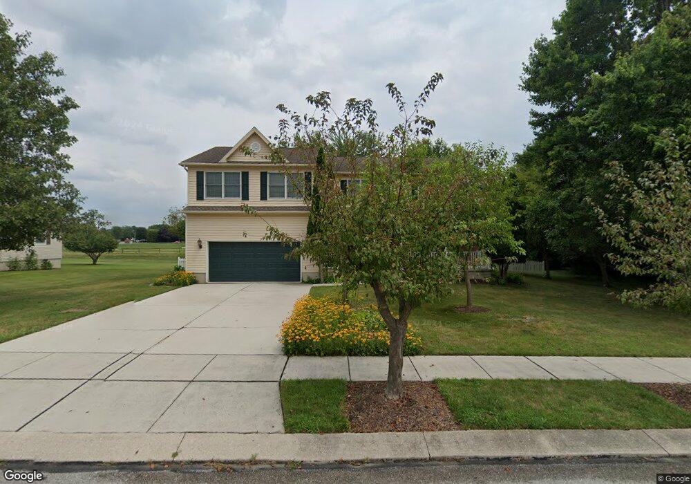
19 Lynx Dr Unit 130 Hanover, PA 17331
Estimated Value: $389,000 - $442,000
4
Beds
3
Baths
2,752
Sq Ft
$149/Sq Ft
Est. Value
About This Home
This home is located at 19 Lynx Dr Unit 130, Hanover, PA 17331 and is currently estimated at $410,653, approximately $149 per square foot. 19 Lynx Dr Unit 130 is a home located in Adams County with nearby schools including New Oxford Senior High School, St. Teresa of Calcutta Catholic School - McSherrystown Campus, and St. Teresa of Calcutta Catholic School - Conewago Campus.
Ownership History
Date
Name
Owned For
Owner Type
Purchase Details
Closed on
Nov 14, 1990
Bought by
Motter David P and Motter Margaret A
Current Estimated Value
Create a Home Valuation Report for This Property
The Home Valuation Report is an in-depth analysis detailing your home's value as well as a comparison with similar homes in the area
Home Values in the Area
Average Home Value in this Area
Purchase History
| Date | Buyer | Sale Price | Title Company |
|---|---|---|---|
| Motter David P | $120,000 | -- |
Source: Public Records
Mortgage History
| Date | Status | Borrower | Loan Amount |
|---|---|---|---|
| Open | Motter David P | $196,854 |
Source: Public Records
Tax History Compared to Growth
Tax History
| Year | Tax Paid | Tax Assessment Tax Assessment Total Assessment is a certain percentage of the fair market value that is determined by local assessors to be the total taxable value of land and additions on the property. | Land | Improvement |
|---|---|---|---|---|
| 2025 | $6,358 | $265,500 | $42,300 | $223,200 |
| 2024 | $5,873 | $265,500 | $42,300 | $223,200 |
| 2023 | $5,656 | $265,500 | $42,300 | $223,200 |
| 2022 | $5,482 | $265,500 | $42,300 | $223,200 |
| 2021 | $5,342 | $265,500 | $42,300 | $223,200 |
| 2020 | $5,350 | $265,500 | $42,300 | $223,200 |
| 2019 | $5,110 | $265,500 | $42,300 | $223,200 |
| 2018 | $5,002 | $265,500 | $42,300 | $223,200 |
| 2017 | $4,796 | $265,500 | $42,300 | $223,200 |
| 2016 | -- | $265,500 | $42,300 | $223,200 |
| 2015 | -- | $265,500 | $42,300 | $223,200 |
| 2014 | -- | $265,500 | $42,300 | $223,200 |
Source: Public Records
Map
Nearby Homes
- 11 Lynx Dr Unit 129
- 27 Lynx Dr Unit 131A
- 29 Lynx Dr Unit 131B
- 14 Lynx Dr Unit 235
- 39 Lynx Dr Unit 132A
- 34 Lynx Dr Unit 237
- 7 Lynx Dr Unit 128
- 4 Lynx Dr Unit 234
- 775 Poplar St Unit 246
- 41 Lynx Dr Unit 132B
- 785 Poplar St Unit 245
- 44 Lynx Dr Unit 238
- 3 Lynx Dr Unit 127
- 51 Lynx Dr Unit 133A
- 793 Poplar St Unit 244
- 737 Poplar St Unit 126
- 54 Lynx Dr Unit 239
- 53 Lynx Dr Unit 133B
- 39 Ram Dr
- 729 Poplar St Unit 125