


19 Mckinley Rd Worcester, MA 01605
Brittan Square NeighborhoodEstimated payment $2,474/month
Highlights
- Colonial Architecture
- Wood Flooring
- 2 Car Detached Garage
- Property is near public transit
- No HOA
- Porch
About This Home
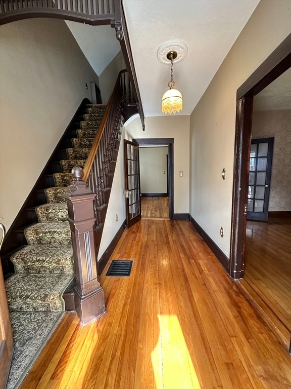
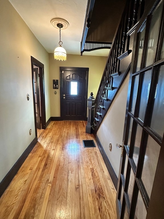
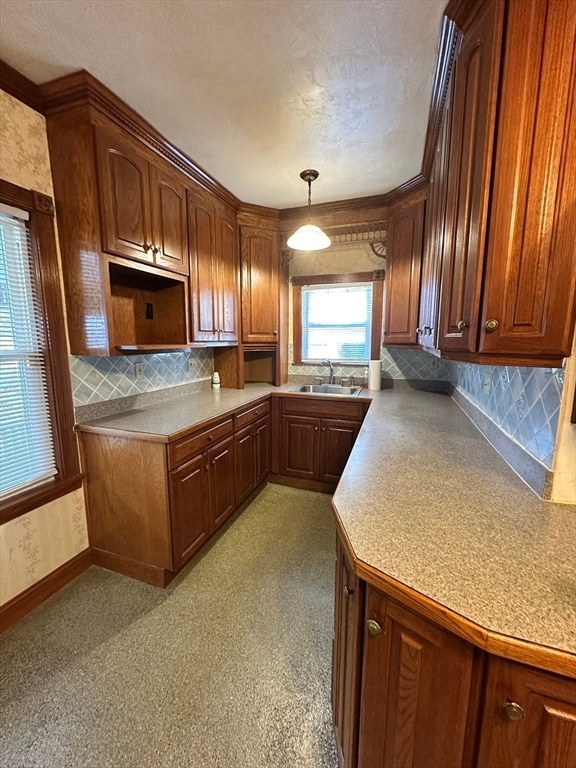
First showings Open House Sunday Nov 2nd 11-12:30. Nestled in the heart of Worcester this home presents a unique opportunity to own a single-family residence that exudes character and potential. The residence features three bedrooms and one and a half bathrooms, lots of gleaming hardwoods, beautiful woodwork, stain glass windows and yes it has Central-Air too! With over1400+ square feet of living area, the interior spaces offer a flexible layout that can be adapted to suit a variety of lifestyles. This Home has been well maintained over the years, it is vinyl sided, roof with architechural shingles and a front porch with trex decking.There is plenty of parking including a two-car garage and additional storage options both inside the home and in the garage. Stop by the Open House Sunday Nov 2nd 11-12:30 and check it out for yourself, you won't be disappointed!
Home Details
Home Type
- Single Family
Est. Annual Taxes
- $4,438
Year Built
- Built in 1890
Lot Details
- 5,354 Sq Ft Lot
- Property is zoned RG-5
Parking
- 2 Car Detached Garage
- Driveway
- Open Parking
- Off-Street Parking
Home Design
- Colonial Architecture
- Stone Foundation
- Frame Construction
- Shingle Roof
Interior Spaces
- 1,422 Sq Ft Home
- Entryway
- Basement Fills Entire Space Under The House
Flooring
- Wood
- Carpet
Bedrooms and Bathrooms
- 3 Bedrooms
- Primary bedroom located on second floor
- Double Vanity
Laundry
- Laundry on main level
- Dryer
- Washer
Outdoor Features
- Rain Gutters
- Porch
Location
- Property is near public transit
Utilities
- Forced Air Heating and Cooling System
- Heating System Uses Natural Gas
- Gas Water Heater
Community Details
- No Home Owners Association
- Shops
Listing and Financial Details
- Assessor Parcel Number M:09 B:013 L:00026,1771004
Map
Home Values in the Area
Average Home Value in this Area
Tax History
| Year | Tax Paid | Tax Assessment Tax Assessment Total Assessment is a certain percentage of the fair market value that is determined by local assessors to be the total taxable value of land and additions on the property. | Land | Improvement |
|---|---|---|---|---|
| 2025 | $4,438 | $336,500 | $84,200 | $252,300 |
| 2024 | $4,238 | $308,200 | $84,200 | $224,000 |
| 2023 | $4,096 | $285,600 | $73,200 | $212,400 |
| 2022 | $3,809 | $250,400 | $58,600 | $191,800 |
| 2021 | $3,736 | $229,500 | $46,900 | $182,600 |
| 2020 | $3,546 | $208,600 | $46,500 | $162,100 |
| 2019 | $3,402 | $189,000 | $40,600 | $148,400 |
| 2018 | $3,389 | $179,200 | $40,600 | $138,600 |
| 2017 | $3,240 | $168,600 | $40,600 | $128,000 |
| 2016 | $3,269 | $158,600 | $29,500 | $129,100 |
| 2015 | $3,183 | $158,600 | $29,500 | $129,100 |
| 2014 | $3,099 | $158,600 | $29,500 | $129,100 |
Property History
| Date | Event | Price | List to Sale | Price per Sq Ft |
|---|---|---|---|---|
| 10/30/2025 10/30/25 | For Sale | $399,900 | -- | $281 / Sq Ft |
Purchase History
| Date | Type | Sale Price | Title Company |
|---|---|---|---|
| Quit Claim Deed | -- | None Available | |
| Quit Claim Deed | -- | None Available | |
| Deed | -- | None Available | |
| Deed | -- | None Available |
Source: MLS Property Information Network (MLS PIN)
MLS Number: 73442226
APN: WORC-000009-000013-000026
Disclaimer: Certain information contained herein is derived from information provided by parties other than Homes.com. All information provided is deemed reliable, but is not guaranteed to be accurate and should be independently verified.
![]() The property listing data and information, or the Images, set forth herein were provided to MLS Property Information Network, Inc. from third party sources, including sellers, lessors and public records, and were compiled by MLS Property Information Network, Inc. The property listing data and information, and the Images, are for the personal, non-commercial use of consumers having a good faith interest in purchasing or leasing listed properties of the type displayed to them and may not be used for any purpose other than to identify prospective properties which such consumers may have a good faith interest in purchasing or leasing. MLS Property Information Network, Inc. and its subscribers disclaim any and all representations and warranties as to the accuracy of the property listing data and information, or as to the accuracy of any of the Images, set forth herein.
The property listing data and information, or the Images, set forth herein were provided to MLS Property Information Network, Inc. from third party sources, including sellers, lessors and public records, and were compiled by MLS Property Information Network, Inc. The property listing data and information, and the Images, are for the personal, non-commercial use of consumers having a good faith interest in purchasing or leasing listed properties of the type displayed to them and may not be used for any purpose other than to identify prospective properties which such consumers may have a good faith interest in purchasing or leasing. MLS Property Information Network, Inc. and its subscribers disclaim any and all representations and warranties as to the accuracy of the property listing data and information, or as to the accuracy of any of the Images, set forth herein.
- 17 Duxbury Rd Unit 3
- 51 Windsor St Unit 2
- 213 Lincoln St Unit 2R
- 213 Lincoln St Unit 1F
- 2 Sturgis St Unit 3
- 109 Green Hill Pkwy Unit 1
- 82 Green Hill Pkwy Unit 2
- 74 Green Hill Pkwy Unit 3
- 58 Paine St Unit 1
- 17 Windsor St Unit 1R
- 16 Dixon Ave
- 28 Hermitage Ln Unit First Floor
- 27 Mount Vernon St
- 104 Rodney St Unit 1
- 44 Byron St
- 21 Henchman St Unit 3
- 92 Stanton St Unit 3rd Floor 4 bedrooms
- 80 Stanton St
- 10 Channing St Unit 3
- 35 Oak Ave Unit 3
