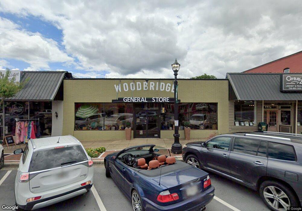
19 N Main St Jasper, GA 30143
Estimated Value: $717,147
Studio
--
Bath
5,160
Sq Ft
$139/Sq Ft
Est. Value
About This Home
This home is located at 19 N Main St, Jasper, GA 30143 and is currently estimated at $717,147, approximately $138 per square foot. 19 N Main St is a home located in Pickens County with nearby schools including Harmony Elementary School, Pickens County Middle School, and Pickens County High School.
Ownership History
Date
Name
Owned For
Owner Type
Purchase Details
Closed on
Jun 1, 2023
Sold by
Roland Jeffrey
Bought by
Wbgs Holdings Llc
Current Estimated Value
Purchase Details
Closed on
Feb 6, 2020
Sold by
Copeland Luke
Bought by
Roland Jeffrey and Roland Carrie S
Purchase Details
Closed on
Jul 11, 2017
Bought by
Copeland Luke
Home Financials for this Owner
Home Financials are based on the most recent Mortgage that was taken out on this home.
Original Mortgage
$114,750
Interest Rate
3.91%
Mortgage Type
Commercial
Purchase Details
Closed on
Jan 6, 2015
Sold by
Langley Ben C and Langley Nan E
Bought by
Stearns Bank Na
Purchase Details
Closed on
Dec 2, 1997
Bought by
Langley Ben C
Create a Home Valuation Report for This Property
The Home Valuation Report is an in-depth analysis detailing your home's value as well as a comparison with similar homes in the area
Home Values in the Area
Average Home Value in this Area
Purchase History
| Date | Buyer | Sale Price | Title Company |
|---|---|---|---|
| Wbgs Holdings Llc | $650,000 | -- | |
| Roland Jeffrey | -- | -- | |
| Copeland Luke | $135,000 | -- | |
| Stearns Bank Na | -- | -- | |
| Stearns Bank | $212,000 | -- | |
| Langley Ben C | $178,000 | -- |
Source: Public Records
Mortgage History
| Date | Status | Borrower | Loan Amount |
|---|---|---|---|
| Previous Owner | Copeland Luke | $114,750 |
Source: Public Records
Tax History
| Year | Tax Paid | Tax Assessment Tax Assessment Total Assessment is a certain percentage of the fair market value that is determined by local assessors to be the total taxable value of land and additions on the property. | Land | Improvement |
|---|---|---|---|---|
| 2025 | $6,244 | $251,421 | $61,600 | $189,821 |
| 2024 | $6,435 | $252,915 | $61,600 | $191,315 |
| 2023 | $5,404 | $207,918 | $61,600 | $146,318 |
| 2022 | $4,229 | $207,918 | $61,600 | $146,318 |
| 2021 | $4,530 | $207,918 | $61,600 | $146,318 |
| 2020 | $4,666 | $207,918 | $61,600 | $146,318 |
| 2019 | $2,988 | $130,160 | $41,580 | $88,580 |
| 2018 | $2,606 | $112,444 | $41,580 | $70,864 |
Source: Public Records
Map
Nearby Homes
- 365 Summit View Ln
- 288 Blazingstar Trail
- 0 Black Hawk Place Lot 242 Unit 7715035
- 0 Black Hawk Place Lot 242 Unit 10686039
- 365 Summit View Ln Unit 6
- TBD Cowart Mountain Tract 3 Rd
- 172 Jacobs Way Unit A,B,C,D
- 172 Jacobs Way
- 8266 Cox Mountain Dr
- 5566 Red Fox Ln
- 0 Hunters Ridge Rd Unit 7714906
- 2668 Highland Trail
- 5574 Red Fox Ln
- 80 Mountain Mint Dr
- 0 Hunters Ridge Rd Unit 10685847
- 280 Vistaview Pkwy
- 321 Owls Brow
- 0 Mulberry Cir Unit 409241
- 0 Hunters Ridge Rd Unit 10685863
- 0 Hunters Ridge Rd Unit 7714898
- 25 N Main St
- 25 N Main St Unit Lot 3
- 15 N Main St
- 35 N Main St
- 35 N Main St Unit B
- 140 Mark Whitfield St Unit A
- 140 Mark Whitfield St
- 140 Mark Whitfield St Unit E
- 140 Mark Whitfield St Unit A
- 140 Mark Whitfield St Unit E
- 140 Mark Whitfield St Unit D
- 140 Mark Whitfield St Unit D
- 140 Mark Whitfield St Unit A
- 140 Mark Whitfield St Unit C
- 140 Mark Whitfield St Unit C
- 67 Mark Whitfield St
- 57 N Main St
- 50 Mark Whitfield Dr
- 14 Mark Whitfield St Unit 15
- 14 Mark Whitfield St
Your Personal Tour Guide
Ask me questions while you tour the home.