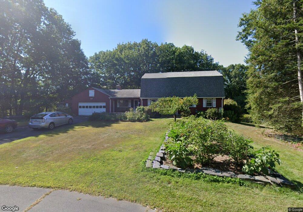
19 Nelson Cir Amherst, MA 01002
Estimated Value: $631,726 - $696,000
4
Beds
2
Baths
2,052
Sq Ft
$326/Sq Ft
Est. Value
About This Home
This home is located at 19 Nelson Cir, Amherst, MA 01002 and is currently estimated at $668,682, approximately $325 per square foot. 19 Nelson Cir is a home located in Hampshire County with nearby schools including Wildwood Elementary School, Amherst Regional Middle School, and Amherst Regional High School.
Ownership History
Date
Name
Owned For
Owner Type
Purchase Details
Closed on
Jul 17, 2024
Sold by
Donoghue John F and Donoghue Elaine J
Bought by
Donoghue Ft and Donoghue
Current Estimated Value
Purchase Details
Closed on
Jun 16, 1986
Bought by
Donoghue John F and Donoghue Elaine J
Create a Home Valuation Report for This Property
The Home Valuation Report is an in-depth analysis detailing your home's value as well as a comparison with similar homes in the area
Home Values in the Area
Average Home Value in this Area
Purchase History
| Date | Buyer | Sale Price | Title Company |
|---|---|---|---|
| Donoghue Ft | -- | None Available | |
| Donoghue Ft | -- | None Available | |
| Donoghue John F | $141,600 | -- |
Source: Public Records
Mortgage History
| Date | Status | Borrower | Loan Amount |
|---|---|---|---|
| Previous Owner | Donoghue John F | $200,000 | |
| Previous Owner | Donoghue John F | $20,000 | |
| Previous Owner | Donoghue John F | $43,000 | |
| Previous Owner | Donoghue John F | $45,000 |
Source: Public Records
Tax History
| Year | Tax Paid | Tax Assessment Tax Assessment Total Assessment is a certain percentage of the fair market value that is determined by local assessors to be the total taxable value of land and additions on the property. | Land | Improvement |
|---|---|---|---|---|
| 2025 | $103 | $575,000 | $189,300 | $385,700 |
| 2024 | $10,053 | $543,100 | $178,700 | $364,400 |
| 2023 | $9,570 | $476,100 | $162,700 | $313,400 |
| 2022 | $9,484 | $445,900 | $147,800 | $298,100 |
| 2021 | $9,012 | $413,000 | $137,000 | $276,000 |
| 2020 | $8,805 | $413,000 | $137,000 | $276,000 |
| 2019 | $8,461 | $388,100 | $137,000 | $251,100 |
| 2018 | $8,204 | $388,100 | $137,000 | $251,100 |
| 2017 | $8,160 | $373,800 | $130,600 | $243,200 |
| 2016 | $7,932 | $373,800 | $130,600 | $243,200 |
| 2015 | $7,678 | $373,800 | $130,600 | $243,200 |
Source: Public Records
Map
Nearby Homes
- 12 Teawaddle Ln
- 185 Cherry Ln
- Lot A Kingman Rd
- 0 Henry St
- 39 Valley Ln
- Lot 3A-3 Leverett Rd
- 60 Red Gate Ln
- 11 Overlook Dr
- 0 Red Gate Ln Unit 73348273
- 270 N East St
- 60 Overlook Dr
- Lot 3 Roosevelt St
- 48 Gray St
- 113 Juggler Meadow Rd
- 174 Lincoln Ave
- 0 Main St
- 75 Amity Place Unit 75
- 63 Amity Place Unit 63
- 3 Frost Ln
- 6 Shattuck Rd
- 80 Rolling Ridge Rd
- 94 Rolling Ridge Rd
- 20 Nelson Cir
- 108 Rolling Ridge Rd
- 60 Rolling Ridge Rd
- 49 Harlow Dr
- 57 Harlow Dr
- 43 Harlow Dr
- 65 Harlow Dr
- 46 Rolling Ridge Rd
- 89 Rolling Ridge Rd
- 73 Harlow Dr
- 35 Harlow Dr
- 77 Rolling Ridge Rd
- 4 Teawaddle Ln
- 120 Rolling Ridge Rd
- 10 Bellview Cir
- 822 E Pleasant St
- 27 Harlow Dr
- 81 Harlow Dr
Your Personal Tour Guide
Ask me questions while you tour the home.