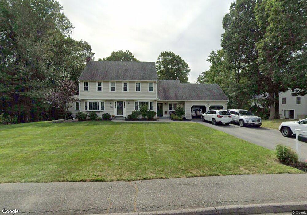
19 Pheasant Ridge Rd Canton, MA 02021
Estimated Value: $1,164,606 - $1,446,000
4
Beds
3
Baths
2,600
Sq Ft
$499/Sq Ft
Est. Value
About This Home
This home is located at 19 Pheasant Ridge Rd, Canton, MA 02021 and is currently estimated at $1,296,652, approximately $498 per square foot. 19 Pheasant Ridge Rd is a home located in Norfolk County with nearby schools including Canton High School and St. John the Evangelist School.
Ownership History
Date
Name
Owned For
Owner Type
Purchase Details
Closed on
Jul 10, 2006
Sold by
Healy Thomas J and Healy Judith A
Bought by
Fitzpatrick Scott and Fitzpatrick Brenda
Current Estimated Value
Create a Home Valuation Report for This Property
The Home Valuation Report is an in-depth analysis detailing your home's value as well as a comparison with similar homes in the area
Home Values in the Area
Average Home Value in this Area
Purchase History
| Date | Buyer | Sale Price | Title Company |
|---|---|---|---|
| Fitzpatrick Scott | $735,000 | -- |
Source: Public Records
Tax History
| Year | Tax Paid | Tax Assessment Tax Assessment Total Assessment is a certain percentage of the fair market value that is determined by local assessors to be the total taxable value of land and additions on the property. | Land | Improvement |
|---|---|---|---|---|
| 2025 | $11,061 | $1,118,400 | $416,500 | $701,900 |
| 2024 | $10,805 | $1,083,800 | $400,600 | $683,200 |
| 2023 | $10,193 | $964,300 | $400,600 | $563,700 |
| 2022 | $10,150 | $894,300 | $381,400 | $512,900 |
| 2021 | $9,899 | $811,400 | $346,800 | $464,600 |
| 2020 | $9,273 | $758,200 | $342,500 | $415,700 |
| 2019 | $9,097 | $733,600 | $311,300 | $422,300 |
| 2018 | $8,770 | $706,100 | $299,300 | $406,800 |
| 2017 | $8,925 | $697,800 | $293,500 | $404,300 |
| 2016 | $8,710 | $681,000 | $286,300 | $394,700 |
| 2015 | $8,436 | $658,000 | $278,000 | $380,000 |
Source: Public Records
Map
Nearby Homes
- 630 Pleasant St
- 611 Pleasant St
- 4 Jeffrey Rd
- 859 Pleasant St
- 23 Pine St Unit K
- 19 Pine St Unit K
- 60 Coppersmith Way Unit 304
- 55 Will Dr Unit 152
- 42 Will Dr Unit 49
- 20 Audubon Way Unit 205
- 20 Audubon Way Unit 302
- 20 Audubon Way Unit 109
- 20 Audubon Way Unit 408
- 20 Audubon Way Unit 210
- 20 Audubon Way Unit 104
- 20 Audubon Way Unit 101
- 888 Turnpike St
- 6 Audubon Way Unit 6
- 8 Audubon Way
- 26 Pequit St
- 23 Pheasant Ridge Rd
- 22 Quail Run
- 15 Pheasant Ridge Rd
- 22 Pheasant Ridge Rd
- 18 Pheasant Ridge Rd
- 18 Quail Run
- 54 Angela St
- 15 Quail Run
- 26 Pheasant Ridge Rd
- 10 Pheasant Ridge Rd
- 50 Angela St
- 14 Pheasant Ridge Rd
- 14 Quail Run
- 6 Pheasant Ridge Rd
- 9 Quail Run
- 46 Angela St
- 65 Angela St
- 62 Angela St
- 61 Angela St
- 69 Angela St
Your Personal Tour Guide
Ask me questions while you tour the home.