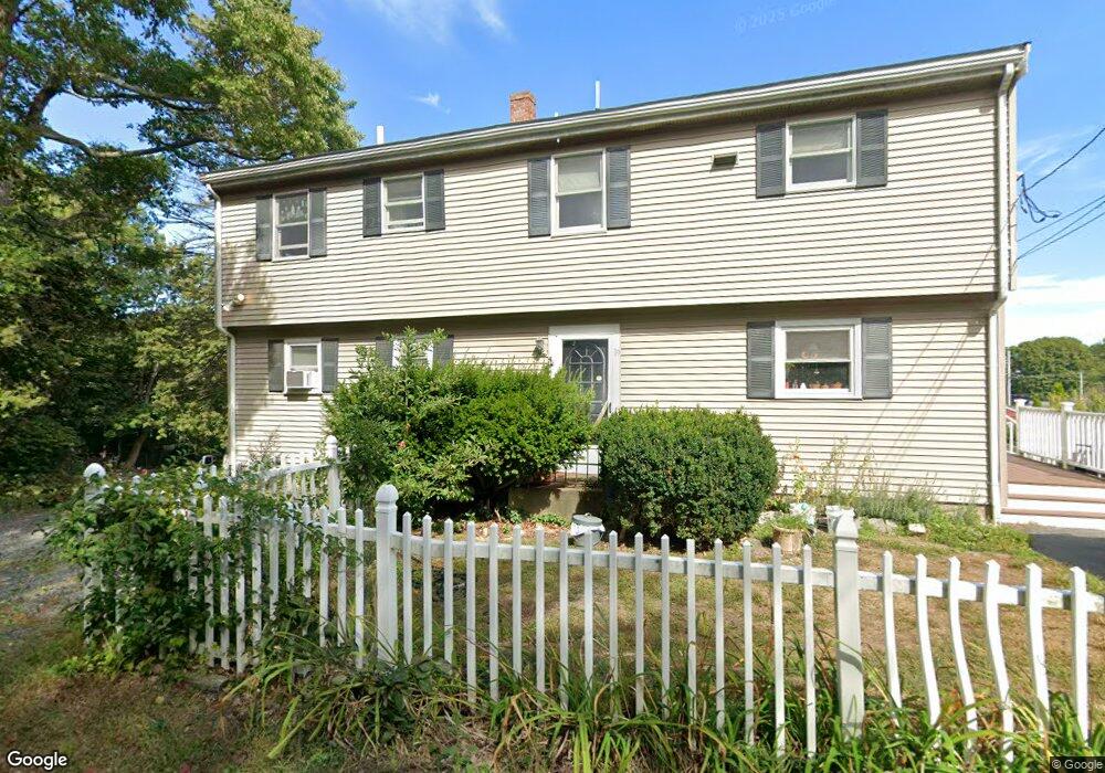
19 Riverview Rd Gloucester, MA 01930
Riverview NeighborhoodEstimated Value: $775,658 - $884,000
6
Beds
3
Baths
2,772
Sq Ft
$297/Sq Ft
Est. Value
About This Home
This home is located at 19 Riverview Rd, Gloucester, MA 01930 and is currently estimated at $823,665, approximately $297 per square foot. 19 Riverview Rd is a home located in Essex County with nearby schools including Beeman Memorial, Ralph B O'maley Middle School, and Gloucester High School.
Ownership History
Date
Name
Owned For
Owner Type
Purchase Details
Closed on
Jun 17, 2024
Sold by
Ohanley Robert P
Bought by
19 Rivview Road Rlty Llc
Current Estimated Value
Purchase Details
Closed on
Nov 1, 1999
Sold by
Parisi Nick A and Parisi Linn M
Bought by
Sylvain Richard and Sylvain Carol J
Create a Home Valuation Report for This Property
The Home Valuation Report is an in-depth analysis detailing your home's value as well as a comparison with similar homes in the area
Home Values in the Area
Average Home Value in this Area
Purchase History
| Date | Buyer | Sale Price | Title Company |
|---|---|---|---|
| 19 Rivview Road Rlty Llc | -- | None Available | |
| 19 Rivview Road Rlty Llc | -- | None Available | |
| Sylvain Richard | $185,000 | -- | |
| Sylvain Richard | $185,000 | -- |
Source: Public Records
Mortgage History
| Date | Status | Borrower | Loan Amount |
|---|---|---|---|
| Previous Owner | Sylvain Richard | $79,300 | |
| Previous Owner | Sylvain Richard | $218,000 | |
| Previous Owner | Sylvain Richard | $135,000 |
Source: Public Records
Tax History
| Year | Tax Paid | Tax Assessment Tax Assessment Total Assessment is a certain percentage of the fair market value that is determined by local assessors to be the total taxable value of land and additions on the property. | Land | Improvement |
|---|---|---|---|---|
| 2025 | $7,002 | $720,400 | $215,100 | $505,300 |
| 2024 | $6,864 | $705,400 | $204,800 | $500,600 |
| 2023 | $7,064 | $667,000 | $182,900 | $484,100 |
| 2022 | $6,591 | $561,900 | $155,500 | $406,400 |
| 2021 | $6,536 | $525,400 | $141,300 | $384,100 |
| 2020 | $6,257 | $507,500 | $141,300 | $366,200 |
| 2019 | $5,846 | $460,700 | $141,300 | $319,400 |
| 2018 | $5,478 | $423,700 | $141,300 | $282,400 |
| 2017 | $5,240 | $397,300 | $134,600 | $262,700 |
| 2016 | $5,055 | $371,400 | $135,100 | $236,300 |
| 2015 | $4,970 | $364,100 | $135,100 | $229,000 |
Source: Public Records
Map
Nearby Homes
- 13 Honeysuckle Rd
- 31 Echo Ave
- 2 Finch Ln
- 2 Breezy Point Rd
- 6 Monroe Ct
- 13 Mystic Ave
- 8 Mystic Ave
- 98 Maplewood Ave
- 167 Atlantic St
- 145 Essex Ave Unit 402
- 15 Harvard St
- 5 Samoset Rd Unit B
- 5 Lepage Ln
- 40 Sargent St
- 672 Washington St
- 33 Maplewood Ave Unit 310
- 33 Maplewood Ave Unit 16
- 20 Beacon St
- 20 Beacon St Unit 2
- 20 Beacon St Unit 1
Your Personal Tour Guide
Ask me questions while you tour the home.