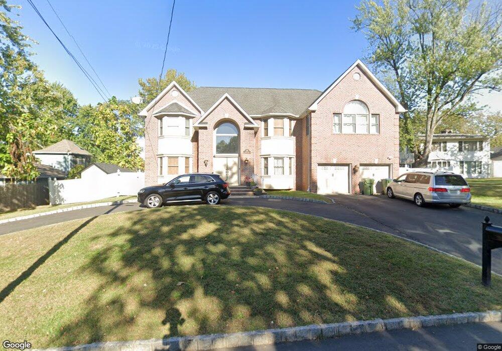
19 Skytop Rd Edison, NJ 08820
Estimated Value: $1,301,000 - $1,757,000
5
Beds
3
Baths
4,200
Sq Ft
$358/Sq Ft
Est. Value
About This Home
This home is located at 19 Skytop Rd, Edison, NJ 08820 and is currently estimated at $1,504,573, approximately $358 per square foot. 19 Skytop Rd is a home located in Middlesex County with nearby schools including Woodbrook Elementary School, Woodrow Wilson Middle School, and J.P. Stevens High School.
Ownership History
Date
Name
Owned For
Owner Type
Purchase Details
Closed on
Aug 29, 2025
Sold by
Yam Arthur and Yam Ming Chan
Bought by
Chan Yam Ming
Current Estimated Value
Purchase Details
Closed on
Sep 11, 2008
Home Financials for this Owner
Home Financials are based on the most recent Mortgage that was taken out on this home.
Original Mortgage
$834,000
Interest Rate
6.54%
Mortgage Type
Purchase Money Mortgage
Purchase Details
Closed on
Mar 24, 2008
Sold by
Borakos John
Bought by
A Ferraro Construction Llc
Home Financials for this Owner
Home Financials are based on the most recent Mortgage that was taken out on this home.
Original Mortgage
$694,200
Interest Rate
6.3%
Mortgage Type
Construction
Create a Home Valuation Report for This Property
The Home Valuation Report is an in-depth analysis detailing your home's value as well as a comparison with similar homes in the area
Home Values in the Area
Average Home Value in this Area
Purchase History
| Date | Buyer | Sale Price | Title Company |
|---|---|---|---|
| Chan Yam Ming | -- | M A D Title Agency | |
| -- | $1,043,500 | -- | |
| Yam Arthur | $1,043,499 | East Coast Title | |
| A Ferraro Construction Llc | $400,000 | -- |
Source: Public Records
Mortgage History
| Date | Status | Borrower | Loan Amount |
|---|---|---|---|
| Previous Owner | Yam Arthur | $834,000 | |
| Previous Owner | A Ferraro Construction Llc | $694,200 |
Source: Public Records
Tax History
| Year | Tax Paid | Tax Assessment Tax Assessment Total Assessment is a certain percentage of the fair market value that is determined by local assessors to be the total taxable value of land and additions on the property. | Land | Improvement |
|---|---|---|---|---|
| 2025 | $26,765 | $455,000 | $110,400 | $344,600 |
| 2024 | $26,621 | $449,600 | $110,400 | $339,200 |
Source: Public Records
Map
Nearby Homes
- 354 Plainfield Rd
- 21 Williams Rd
- 4 David Ct
- 8 Stephenville Pkwy
- 3851 Park Ave
- 64 Richard Rd
- 454 Plainfield Rd
- 3996 Park Ave
- 33 Nottingham Rd
- 35 Carriage Place
- 28 Nicole Terrace
- 89 Park Gate Dr
- 265 Plainfield Rd
- 15 Hearthstone Dr
- 118 Coppertree Ct
- 114 Coppertree Ct
- 3774 Park Ave Unit 1
- 3774 Park Ave
- 9 Links Dr
- 83 Sagamore Ave S
- 15 Sunset Ave
- 30 Stephenville Pw
- 30 Stephenville Pkwy
- 32 Stephenville Pkwy
- 22 Homestead Rd
- 20 Homestead Rd
- 20 Skytop Rd
- 7 Sunset Ave
- 18 Skytop Rd
- 14 Sunset Ave
- 34 Stephenville Pkwy
- 34 Stephenville Pw
- 16 Skytop Rd
- 31 Stephenville Pkwy
- 27 Stephenville Pw
- 16 Homestead Rd
- 29 Stephenville Pkwy
- 15 Skytop Rd
- 17 Homestead Rd
- 27 Stephenville Pkwy
Your Personal Tour Guide
Ask me questions while you tour the home.