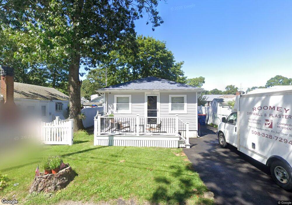
19 Swift Ave Unit WINTER Wareham, MA 02571
Wareham Center NeighborhoodEstimated Value: $355,000 - $382,686
2
Beds
1
Bath
720
Sq Ft
$508/Sq Ft
Est. Value
About This Home
This home is located at 19 Swift Ave Unit WINTER, Wareham, MA 02571 and is currently estimated at $365,922, approximately $508 per square foot. 19 Swift Ave Unit WINTER is a home located in Plymouth County.
Ownership History
Date
Name
Owned For
Owner Type
Purchase Details
Closed on
May 31, 2022
Sold by
Lancaster Laureen J
Bought by
Lancaster Laureen J and Roomey Richard M
Current Estimated Value
Purchase Details
Closed on
Oct 26, 1998
Sold by
Benson Gary A and Benson Herbert N
Bought by
Lancaster Laureen J
Purchase Details
Closed on
Jul 11, 1995
Sold by
Est Vitiello Anne L and Lamarca Anne D
Bought by
Benson Gary A and Benson Herbert N
Create a Home Valuation Report for This Property
The Home Valuation Report is an in-depth analysis detailing your home's value as well as a comparison with similar homes in the area
Home Values in the Area
Average Home Value in this Area
Purchase History
| Date | Buyer | Sale Price | Title Company |
|---|---|---|---|
| Lancaster Laureen J | -- | None Available | |
| Lancaster Laureen J | -- | None Available | |
| Lancaster Laureen J | $79,000 | -- | |
| Lancaster Laureen J | $79,000 | -- | |
| Benson Gary A | $67,500 | -- | |
| Benson Gary A | $67,500 | -- |
Source: Public Records
Mortgage History
| Date | Status | Borrower | Loan Amount |
|---|---|---|---|
| Previous Owner | Benson Gary A | $25,000 | |
| Previous Owner | Benson Gary A | $20,000 | |
| Previous Owner | Benson Gary A | $78,000 |
Source: Public Records
Tax History
| Year | Tax Paid | Tax Assessment Tax Assessment Total Assessment is a certain percentage of the fair market value that is determined by local assessors to be the total taxable value of land and additions on the property. | Land | Improvement |
|---|---|---|---|---|
| 2025 | $3,172 | $304,400 | $106,600 | $197,800 |
| 2024 | $3,221 | $286,800 | $79,600 | $207,200 |
| 2023 | $2,789 | $254,800 | $72,400 | $182,400 |
| 2022 | $2,789 | $211,600 | $72,400 | $139,200 |
| 2021 | $2,585 | $192,200 | $72,400 | $119,800 |
| 2020 | $2,449 | $184,700 | $72,400 | $112,300 |
| 2019 | $2,144 | $161,300 | $64,700 | $96,600 |
| 2018 | $1,965 | $144,200 | $64,700 | $79,500 |
| 2017 | $1,914 | $142,300 | $64,700 | $77,600 |
| 2016 | $1,739 | $128,500 | $61,600 | $66,900 |
| 2015 | $1,679 | $128,500 | $61,600 | $66,900 |
| 2014 | $1,790 | $139,300 | $61,600 | $77,700 |
Source: Public Records
Map
Nearby Homes
- 21 Bayview St
- 43 Shore Ave
- 20 Grant St
- 10 Barnes St
- 6 Allen Ave
- 58 Shady Ln
- 15 Broadmarsh Ave
- 0 Cromesett Rd (Off) Unit 73385395
- 1 Nimrod Way
- 4 Roosevelt St
- 14 Briarwood Dr
- 12 Taft St
- 233 Marion Rd
- 9 Woodville Way
- 6 Bourne Terrace
- 10 Longmeadow Dr
- 10 Oak St
- 0 Cross Neck Rd Unit 73420524
- 0 Cross Neck Rd Unit 73466177
- 0 Cross Neck Rd Unit 73420525
Your Personal Tour Guide
Ask me questions while you tour the home.