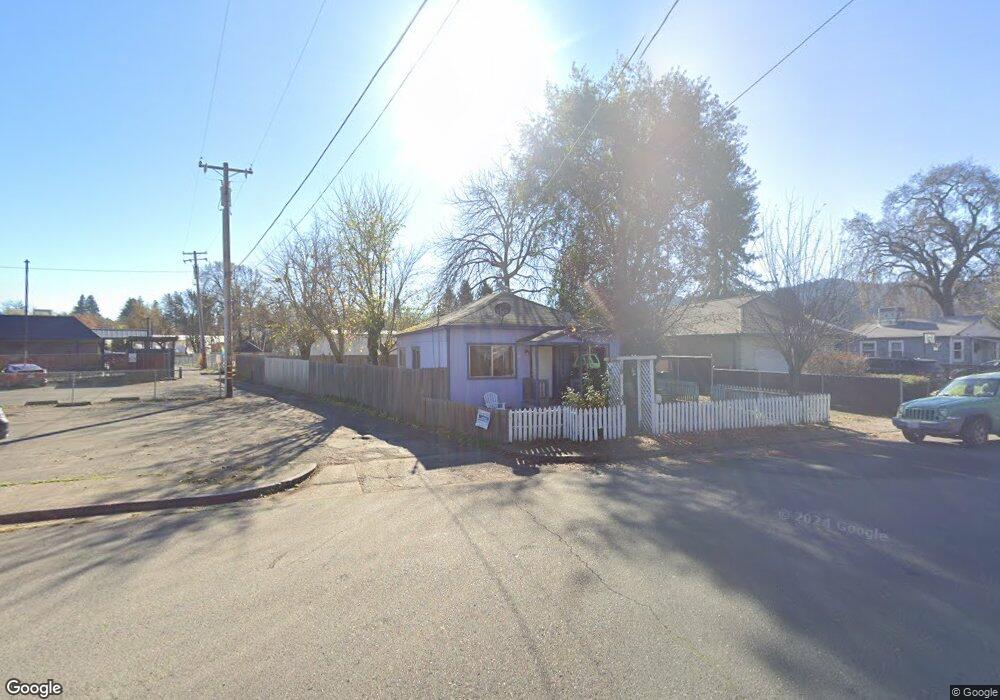
19 W Oak St Willits, CA 95490
Estimated Value: $234,982 - $285,000
2
Beds
1
Bath
750
Sq Ft
$354/Sq Ft
Est. Value
About This Home
This home is located at 19 W Oak St, Willits, CA 95490 and is currently estimated at $265,746, approximately $354 per square foot. 19 W Oak St is a home located in Mendocino County with nearby schools including Blosser Lane Elementary School, Brookside Elementary School, and Baechtel Grove Middle School.
Ownership History
Date
Name
Owned For
Owner Type
Purchase Details
Closed on
Jan 14, 2021
Sold by
Haschak John S and Haschak Janice K
Bought by
Haschak John Stephen and Haschak Janice Katrine
Current Estimated Value
Purchase Details
Closed on
Feb 24, 2011
Sold by
Homesales Inc
Bought by
Haschak John S and Haschak Janice K
Purchase Details
Closed on
Dec 7, 2010
Sold by
Gilly Robert M
Bought by
Homesales Inc
Purchase Details
Closed on
Oct 7, 2002
Sold by
Smits Robert and Smits Jannette A
Bought by
Gilly Robert M
Create a Home Valuation Report for This Property
The Home Valuation Report is an in-depth analysis detailing your home's value as well as a comparison with similar homes in the area
Home Values in the Area
Average Home Value in this Area
Purchase History
| Date | Buyer | Sale Price | Title Company |
|---|---|---|---|
| Haschak John Stephen | -- | None Available | |
| Haschak John S | $55,000 | Chicago Title Company | |
| Homesales Inc | $80,100 | None Available | |
| Gilly Robert M | $98,000 | First American Title Co |
Source: Public Records
Tax History
| Year | Tax Paid | Tax Assessment Tax Assessment Total Assessment is a certain percentage of the fair market value that is determined by local assessors to be the total taxable value of land and additions on the property. | Land | Improvement |
|---|---|---|---|---|
| 2025 | $1,963 | $70,450 | $44,833 | $25,617 |
| 2023 | $1,963 | $67,716 | $43,093 | $24,623 |
| 2022 | $1,798 | $66,390 | $42,249 | $24,141 |
| 2021 | $1,793 | $65,089 | $41,421 | $23,668 |
| 2020 | $1,773 | $64,429 | $41,000 | $23,429 |
| 2019 | $1,772 | $63,165 | $40,196 | $22,969 |
| 2018 | $1,627 | $61,928 | $39,409 | $22,519 |
| 2017 | $1,557 | $60,714 | $38,636 | $22,078 |
| 2016 | $1,501 | $59,524 | $37,879 | $21,645 |
| 2015 | $1,489 | $58,630 | $37,310 | $21,320 |
| 2014 | $1,481 | $57,481 | $36,579 | $20,902 |
Source: Public Records
Map
Nearby Homes
- 316 S Main St
- 1051 S Main St
- 308 Coast St
- 372 S Lenore Ave
- 0 Poplar Ave Unit 324037613
- 0 Catherine Ln
- 1242 Poplar Ave
- 350 Creekside Dr
- 84 School St
- 454 Della Ave
- 490 Della Ave
- 1407 Brothers Ln
- 21441 Pineview Dr
- 25331 Sherwood Rd
- 25201 Sherwood Rd
- 1750 S Main St Unit 37
- 252 Margie Dr
- 26400 Sherwood Rd
- 1700 California 20
- 450 Grove St
- 29 W Oak St
- 35 W Oak St
- 708 S Main St
- 690 S Main St
- 38 Fort Bragg Rd
- 46 Fort Bragg Rd
- 670 S Main St
- 53 W Oak St
- 50 Fort Bragg Rd
- 26 W Oak St
- 46 W Oak St Unit 46-48
- 46 W Oak St
- 660 S Main St
- 38 W Oak St
- 56 Fort Bragg Rd
- 52 W Oak St
- 55 W Oak St
- 675 S Main St
- 630 S Main St
- 0 Parcel 64 Spring Creek (Blue Lake Rd)
Your Personal Tour Guide
Ask me questions while you tour the home.