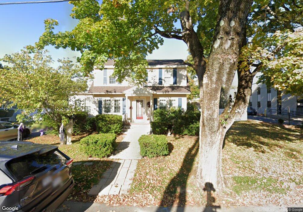
19 Westwood Rd Stoneham, MA 02180
Lindenwood NeighborhoodEstimated Value: $753,000 - $805,804
3
Beds
2
Baths
1,662
Sq Ft
$465/Sq Ft
Est. Value
About This Home
This home is located at 19 Westwood Rd, Stoneham, MA 02180 and is currently estimated at $773,201, approximately $465 per square foot. 19 Westwood Rd is a home located in Middlesex County with nearby schools including Stoneham High School, St. Patrick Elementary School, and St Joseph School.
Ownership History
Date
Name
Owned For
Owner Type
Purchase Details
Closed on
Aug 12, 1992
Sold by
Bellmer Robert
Bought by
Todisco John J
Current Estimated Value
Purchase Details
Closed on
Apr 26, 1991
Sold by
Saugus Bk & Tr Co
Bought by
Bellmer Robert and Todisco John J
Purchase Details
Closed on
Nov 1, 1982
Bought by
Reynolds James A and Reynolds Patricia M
Create a Home Valuation Report for This Property
The Home Valuation Report is an in-depth analysis detailing your home's value as well as a comparison with similar homes in the area
Home Values in the Area
Average Home Value in this Area
Purchase History
| Date | Buyer | Sale Price | Title Company |
|---|---|---|---|
| Todisco John J | $15,000 | -- | |
| Bellmer Robert | $150,000 | -- | |
| Reynolds James A | -- | -- |
Source: Public Records
Mortgage History
| Date | Status | Borrower | Loan Amount |
|---|---|---|---|
| Open | Reynolds James A | $140,000 | |
| Closed | Reynolds James A | $110,000 | |
| Previous Owner | Reynolds James A | $91,000 |
Source: Public Records
Tax History Compared to Growth
Tax History
| Year | Tax Paid | Tax Assessment Tax Assessment Total Assessment is a certain percentage of the fair market value that is determined by local assessors to be the total taxable value of land and additions on the property. | Land | Improvement |
|---|---|---|---|---|
| 2025 | $7,380 | $721,400 | $372,000 | $349,400 |
| 2024 | $7,021 | $663,000 | $344,100 | $318,900 |
| 2023 | $6,811 | $613,600 | $316,200 | $297,400 |
| 2022 | $5,736 | $551,000 | $297,600 | $253,400 |
| 2021 | $5,698 | $526,600 | $279,000 | $247,600 |
| 2020 | $5,493 | $524,100 | $274,800 | $249,300 |
| 2019 | $5,383 | $479,800 | $254,900 | $224,900 |
| 2018 | $5,260 | $454,100 | $229,000 | $225,100 |
| 2017 | $4,747 | $383,100 | $204,200 | $178,900 |
| 2016 | $4,679 | $368,400 | $204,200 | $164,200 |
| 2015 | $4,693 | $362,100 | $204,200 | $157,900 |
| 2014 | $4,650 | $344,700 | $186,500 | $158,200 |
Source: Public Records
Map
Nearby Homes
- 68 Main St Unit 36C
- 64 Main St Unit 41B
- 40 Main St Unit 505
- 97 Oak St
- 62 Abigail Way Unit 3004
- 8 Steele St
- 159 Main St Unit 41C
- 62 High St Unit 4
- 62 High St Unit 3
- 62 High St Unit Lot 12
- 62 High St Unit Lot 2
- 62 High St Unit Lot 7
- 62 High St Unit Lot 9
- 13 Elaine Rd
- 7 Leaning Elm Dr Unit 7
- 97 Macarthur Rd
- 20 Oak St
- 1 Summit Dr Unit 57
- 405 William St
- 2 Summit Dr Unit 18