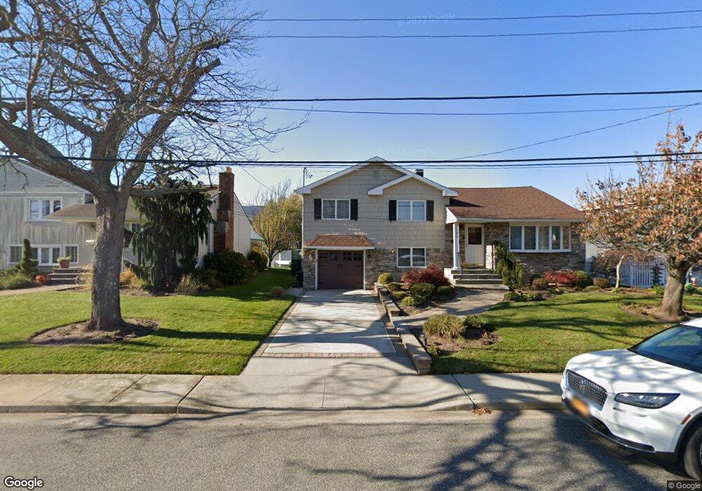
190 Block Ln Island Park, NY 11558
Estimated Value: $1,204,349 - $1,241,000
3
Beds
3
Baths
2,882
Sq Ft
$424/Sq Ft
Est. Value
About This Home
This home is located at 190 Block Ln, Island Park, NY 11558 and is currently estimated at $1,222,675, approximately $424 per square foot. 190 Block Ln is a home with nearby schools including Francis X Hegarty Elementary School and Lincoln Orens Middle School.
Ownership History
Date
Name
Owned For
Owner Type
Purchase Details
Closed on
May 11, 2011
Sold by
Weintraub William M and Weintraub James S
Bought by
Emerson Matthew and Emerson Valerie
Current Estimated Value
Home Financials for this Owner
Home Financials are based on the most recent Mortgage that was taken out on this home.
Original Mortgage
$484,000
Outstanding Balance
$335,892
Interest Rate
4.85%
Mortgage Type
Purchase Money Mortgage
Estimated Equity
$886,783
Purchase Details
Closed on
Aug 16, 2010
Sold by
Pearlstein Carol
Bought by
Weintraub William
Purchase Details
Closed on
Aug 14, 1997
Create a Home Valuation Report for This Property
The Home Valuation Report is an in-depth analysis detailing your home's value as well as a comparison with similar homes in the area
Home Values in the Area
Average Home Value in this Area
Purchase History
| Date | Buyer | Sale Price | Title Company |
|---|---|---|---|
| Emerson Matthew | $605,000 | -- | |
| Weintraub William | -- | -- | |
| -- | -- | -- |
Source: Public Records
Mortgage History
| Date | Status | Borrower | Loan Amount |
|---|---|---|---|
| Open | Emerson Matthew | $484,000 |
Source: Public Records
Tax History Compared to Growth
Tax History
| Year | Tax Paid | Tax Assessment Tax Assessment Total Assessment is a certain percentage of the fair market value that is determined by local assessors to be the total taxable value of land and additions on the property. | Land | Improvement |
|---|---|---|---|---|
| 2025 | $21,785 | $872 | $312 | $560 |
| 2024 | $6,065 | $823 | $282 | $541 |
| 2023 | $20,229 | $909 | $312 | $597 |
| 2022 | $20,229 | $909 | $312 | $597 |
| 2021 | $26,429 | $863 | $296 | $567 |
| 2020 | $20,361 | $1,678 | $1,110 | $568 |
| 2019 | $20,638 | $1,678 | $1,110 | $568 |
| 2018 | $18,913 | $1,672 | $0 | $0 |
| 2017 | $10,656 | $1,672 | $1,110 | $562 |
| 2016 | $17,813 | $1,672 | $1,110 | $562 |
| 2015 | $6,718 | $1,672 | $1,110 | $562 |
| 2014 | $6,718 | $1,672 | $1,110 | $562 |
| 2013 | $6,409 | $1,672 | $1,110 | $562 |
Source: Public Records
Map
Nearby Homes
- 208 Block Ln
- 208 Island Pkwy W
- 227 Mckinley Ave
- 134 Mckinley Ave
- 68 Lincoln Ave
- 5 Sheridan Place
- 31 Kent Rd Unit New Construction!!
- 7 Sherborne Place
- 38 Kent Rd
- 12 Pershing Place
- 185 Quebec Rd
- 227 W Pine St
- 236 W Pine St
- 19 Parma Rd
- 16 E Pine St
- 20 E Pine St
- 261 W Hudson St
- 41 Ostend Rd
- 60 E Pine St
- 450 W Bay Dr
- 186 Block Ln
- 200 Block Ln
- 180 Block Ln
- 183 Island Pkwy W
- 178 Block Ln
- 189 Island Pkwy W
- 167 Island Pkwy W
- 0 Block Ln Unit 3125423
- 201 Island Pkwy W
- 212 Block Ln
- 175 Warwick Blvd
- 178 Island Pkwy W
- 184 Island Pkwy W
- 185 Kent Blvd
- 0 Island Pkwy W Unit 2904596
- 0 Island Pkwy W
- 168 Island Pkwy W
- 190 Island Pkwy W
- 207 Island Pkwy W
- 171 Warwick Blvd