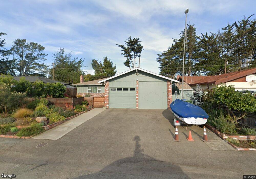
190 Cypress Ln Watsonville, CA 95076
Amesti NeighborhoodEstimated Value: $932,000 - $1,157,000
3
Beds
2
Baths
1,801
Sq Ft
$562/Sq Ft
Est. Value
About This Home
This home is located at 190 Cypress Ln, Watsonville, CA 95076 and is currently estimated at $1,011,892, approximately $561 per square foot. 190 Cypress Ln is a home located in Santa Cruz County with nearby schools including Bradley Elementary School, Aptos Junior High School, and Aptos High School.
Ownership History
Date
Name
Owned For
Owner Type
Purchase Details
Closed on
Dec 2, 2010
Sold by
Verutti Joel M and Verutti Tina Marie
Bought by
Verutti Tina M and Verutti Family Trust
Current Estimated Value
Purchase Details
Closed on
Sep 12, 1994
Sold by
Paxton Jimmie M and Paxton Beverly S
Bought by
Verutti Joel Matthew and Verutti Tina Marie
Home Financials for this Owner
Home Financials are based on the most recent Mortgage that was taken out on this home.
Original Mortgage
$190,000
Interest Rate
8.61%
Create a Home Valuation Report for This Property
The Home Valuation Report is an in-depth analysis detailing your home's value as well as a comparison with similar homes in the area
Home Values in the Area
Average Home Value in this Area
Purchase History
| Date | Buyer | Sale Price | Title Company |
|---|---|---|---|
| Verutti Tina M | -- | None Available | |
| Verutti Joel Matthew | $200,000 | Santa Cruz Title Co |
Source: Public Records
Mortgage History
| Date | Status | Borrower | Loan Amount |
|---|---|---|---|
| Previous Owner | Verutti Joel Matthew | $190,000 |
Source: Public Records
Tax History Compared to Growth
Tax History
| Year | Tax Paid | Tax Assessment Tax Assessment Total Assessment is a certain percentage of the fair market value that is determined by local assessors to be the total taxable value of land and additions on the property. | Land | Improvement |
|---|---|---|---|---|
| 2025 | $4,420 | $375,470 | $184,767 | $190,703 |
| 2023 | $4,343 | $360,891 | $177,593 | $183,298 |
| 2022 | $4,257 | $353,814 | $174,110 | $179,704 |
| 2021 | $4,132 | $346,877 | $170,696 | $176,181 |
| 2020 | $4,075 | $343,320 | $168,946 | $174,374 |
| 2019 | $4,008 | $336,589 | $165,634 | $170,955 |
| 2018 | $3,911 | $329,989 | $162,386 | $167,603 |
| 2017 | $3,883 | $323,518 | $159,201 | $164,317 |
| 2016 | $3,786 | $317,174 | $156,079 | $161,095 |
| 2015 | $3,728 | $312,410 | $153,735 | $158,675 |
| 2014 | $3,651 | $306,291 | $150,724 | $155,567 |
Source: Public Records
Map
Nearby Homes
- 172 W Phillips Rd
- 18 Linden Rd
- 371 Calabasas Rd
- 155 Scarlet Ct
- 571 Calabasas Rd
- 687 Calabasas Rd
- 155 Lita Ln
- 389 Corralitos Rd
- 125 Gilchrist Way
- 27 Burchell Ave
- 125 Lapis Dr
- 261 Wheelock Rd
- 490 Corralitos Rd
- 26 Oliveira Loop
- 221 Carey Ave Unit A
- 101 Toscano Loop
- 4 Holly Dr Unit B
- 16 Browns Valley Rd
- 134 Trabing Rd
- 49 Blanca Ln Unit 310