190 Ferry Rd Saco, ME 04072
East Saco NeighborhoodEstimated Value: $1,194,000 - $1,463,783
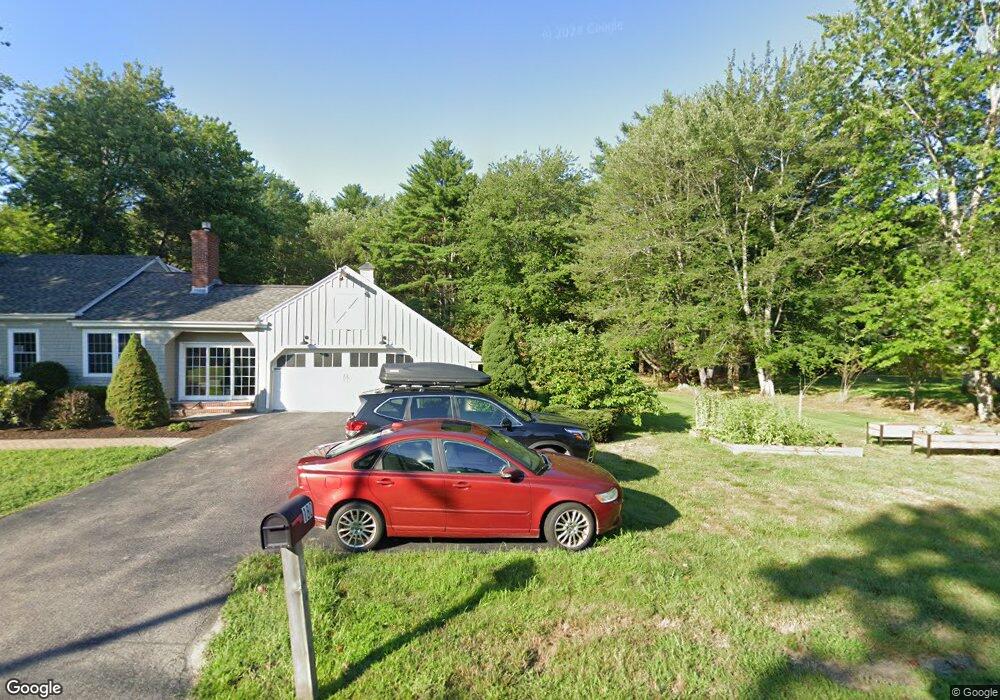
About This Home
Escape to Your Private Oasis on 12 Secluded Acres!
Discover the best of Maine living: total privacy surrounded by nature, yet only a 5-minute drive to the vibrant downtown Saco-Biddeford area.
This unique 1,541 sq. ft. apartment is part of a beautiful, larger home, nestled right against the picturesque Rachel Carson National Wildlife Refuge.
Key Features You'll Love:
Gourmet Kitchen: Recently renovated with sleek countertops, modern stainless steel appliances—perfect for the home chef.
Generous Living Space: The apartment boasts a spacious, open floor plan with custom built-in living room furniture, maximizing both style and comfort.
Work From Home Ready: A dedicated, built-in office area provides the perfect quiet spot for focus and productivity.
Ultimate Privacy: Enjoy unparalleled serenity on 12 beautiful acres. The setting is truly one-of-a-kind.
Convenience Included: Heat and hot water are included in the rent, simplifying your monthly budget!
Parking: Plenty of off-street parking available right on the property.
Location:
Located just a short drive from local shops, award-winning restaurants, and local beaches in Saco and Biddeford. Quick access to major routes for an easy commute.
Available May 1st.
This property is perfect for someone seeking a peaceful, high-quality living experience with all the modern comforts.
Call/text, email for showings
Ownership History
Purchase Details
Purchase Details
Purchase Details
Home Values in the Area
Average Home Value in this Area
Purchase History
| Date | Buyer | Sale Price | Title Company |
|---|---|---|---|
| Hartung Lina V | -- | None Available | |
| Fesenko Investments Llc | -- | None Available | |
| Hartung Lina V | -- | None Available | |
| Hartung Robert J | -- | None Available | |
| Fesenko Investments Llc | -- | None Available | |
| Hartung Lina V | -- | None Available | |
| Hartung Robert J | -- | None Available | |
| Robert J Hartung Ret | -- | -- | |
| Robert J Hartung Ret | -- | -- | |
| Robert J Hartung Ret | -- | -- | |
| Johnson Pamela | -- | -- | |
| Johnson Pamela | -- | -- |
Property History
| Date | Event | Price | List to Sale | Price per Sq Ft |
|---|---|---|---|---|
| 02/10/2025 02/10/25 | Off Market | -- | -- | -- |
| 01/26/2025 01/26/25 | For Rent | -- | -- | -- |
Tax History
| Year | Tax Paid | Tax Assessment Tax Assessment Total Assessment is a certain percentage of the fair market value that is determined by local assessors to be the total taxable value of land and additions on the property. | Land | Improvement |
|---|---|---|---|---|
| 2024 | $15,875 | $1,129,900 | $277,300 | $852,600 |
| 2023 | $13,782 | $934,400 | $277,300 | $657,100 |
| 2022 | $12,307 | $671,400 | $211,800 | $459,600 |
| 2021 | $12,057 | $638,600 | $198,700 | $439,900 |
| 2020 | $11,509 | $585,100 | $179,800 | $405,300 |
| 2019 | $11,339 | $585,100 | $179,800 | $405,300 |
| 2018 | $13,663 | $705,000 | $169,100 | $535,900 |
| 2017 | $237 | $688,800 | $159,500 | $529,300 |
| 2016 | $11,003 | $566,600 | $155,500 | $411,100 |
| 2015 | $10,790 | $561,400 | $155,500 | $405,900 |
| 2014 | $10,453 | $561,400 | $155,500 | $405,900 |
| 2013 | $10,431 | $561,400 | $155,500 | $405,900 |
Map
- 11 Peabody Ln Unit 101
- 2 Breakwater Way Unit 2
- 295 Ferry Rd
- 4 Mainsail Ln Unit 4
- TBD 530 Ferry Rd
- 38 Pine Ridge Rd
- 3 Walker Dr Unit 101
- 4 Walker Dr Unit 101
- 3 Walker Dr Unit 101
- 343 Pool St
- 353 Pool St
- 378 Pool St
- 6 Decary Rd
- 30 Vines Rd
- 8 Heritage Way Unit 21
- 16 Heritage Way Unit 17
- 20 Heritage Way Unit 15
- 25 Heritage Way Unit 11
- 12 Marial Ave
- 3 Old Orchard Rd Unit 7
- 190 Ferry Rd
- 190 Ferry Rd Unit 1
- Lot #5 Richard's Way
- 5 Richards Way
- 7 Richards Way
- 5 Richard's Way
- 7 Richard's Way
- Lot #3 Richard's Way
- 3 Richards Way
- 9 Richards Way
- 188 Ferry Rd
- 180 Ferry Rd
- 1 Richards Way
- 172 Ferry Rd
- 192 Ferry Rd
- 11 Richards Way
- 8 Richards Way
- 198 Ferry Rd
- 166 Ferry Rd
- 6 Clarks Hill Ln
Ask me questions while you tour the home.