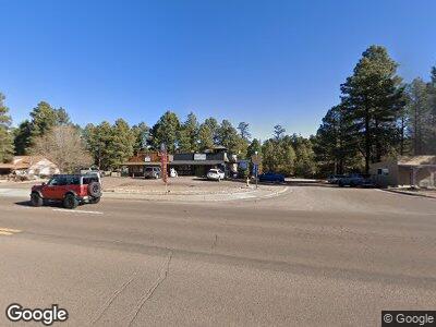
1900 State Route 260 Overgaard, AZ 85933
Estimated Value: $262,467
--
Bed
--
Bath
2,400
Sq Ft
$109/Sq Ft
Est. Value
About This Home
This home is located at 1900 State Route 260, Overgaard, AZ 85933 and is currently estimated at $262,467, approximately $109 per square foot. 1900 State Route 260 is a home located in Navajo County with nearby schools including Mountain Meadows Primary School, Capps Elementary School, and Mogollon Junior High School.
Ownership History
Date
Name
Owned For
Owner Type
Purchase Details
Closed on
Nov 30, 2021
Sold by
Stewart Kenneth J
Bought by
Just Teazzin Llc
Current Estimated Value
Home Financials for this Owner
Home Financials are based on the most recent Mortgage that was taken out on this home.
Original Mortgage
$250,000
Outstanding Balance
$232,226
Interest Rate
3.09%
Mortgage Type
Commercial
Estimated Equity
$30,241
Purchase Details
Closed on
Oct 26, 2015
Sold by
Nelson Gene G and Haneline Aaron E
Bought by
Stewart Kenneth J
Home Financials for this Owner
Home Financials are based on the most recent Mortgage that was taken out on this home.
Original Mortgage
$80,000
Interest Rate
3.81%
Mortgage Type
Seller Take Back
Purchase Details
Closed on
Oct 23, 2012
Sold by
Nelson Gene G and Nelson Gene
Bought by
Nelson Gene G and Haneline Aaron
Create a Home Valuation Report for This Property
The Home Valuation Report is an in-depth analysis detailing your home's value as well as a comparison with similar homes in the area
Home Values in the Area
Average Home Value in this Area
Purchase History
| Date | Buyer | Sale Price | Title Company |
|---|---|---|---|
| Just Teazzin Llc | $250,000 | None Available | |
| Stewart Kenneth J | $85,000 | Pioneer Title Agency | |
| Nelson Gene G | -- | None Available |
Source: Public Records
Mortgage History
| Date | Status | Borrower | Loan Amount |
|---|---|---|---|
| Open | Just Teazzin Llc | $250,000 | |
| Previous Owner | Stewart Kenneth J | $80,000 |
Source: Public Records
Tax History Compared to Growth
Tax History
| Year | Tax Paid | Tax Assessment Tax Assessment Total Assessment is a certain percentage of the fair market value that is determined by local assessors to be the total taxable value of land and additions on the property. | Land | Improvement |
|---|---|---|---|---|
| 2025 | $1,191 | $20,441 | $1,535 | $18,906 |
| 2024 | $1,169 | $21,237 | $1,535 | $19,702 |
| 2023 | $1,191 | $12,937 | $1,535 | $11,402 |
| 2022 | $1,169 | $0 | $0 | $0 |
| 2021 | $1,189 | $0 | $0 | $0 |
| 2020 | $1,155 | $0 | $0 | $0 |
| 2019 | $1,057 | $0 | $0 | $0 |
| 2018 | $1,008 | $0 | $0 | $0 |
| 2017 | $1,092 | $0 | $0 | $0 |
| 2016 | $1,132 | $0 | $0 | $0 |
| 2015 | $1,104 | $10,853 | $1,620 | $9,233 |
Source: Public Records
Map
Nearby Homes
- 1898 State Route 260
- 1979 Little Doe Trail
- 1919 Twin Pines Trail
- 3326 Rim Lakes Dr
- 1987 Stagg Run
- 2026 State Route 277 -- Unit C
- 3318 Little Pine Dr
- 3331 Rim Lakes Dr
- 2952 Country View Ln
- 2010 Christmas Pine Rd
- 1990 Red Deer Run
- 2074 Thousand Pines Dr
- 2075 Thousand Pines Dr
- 3500/3506 Evergreen Dr
- 3305 Forest Dr
- 2954 Pine Rim Rd
- 3512 Quail Run Rd
- 1981 Rustling Pine Dr
- 3518 Black Bear Run
- 3521 Deer Track Trail
- 1915 State Route 260 -- Unit 178
- 1874 State Route 260
- 1900 State Route 260
- 1910 State Route 260
- 2944 State Route 260
- 1934 State Route 260 Unit C
- 1917 State Route 260 Unit 179
- 1874 State Route 260 --
- 2925 State Route 260 --
- 1884 State Route 260
- 1892 State Route 260 Unit /189
- 2925 State Route 260 --
- 2930 State Route 260
- 1934 State Route 260
- 1910 State Route 260 Unit 1912 HWY 260
- 2920 State Route 260
- 1931 State Route 260
- 1931 State Route 260 --
- 1972 State Route 260 --
- 1925 State Route 260 -- Unit 176
