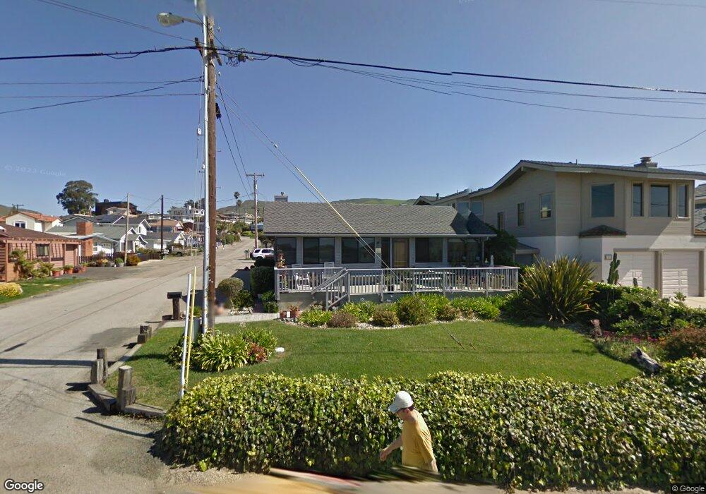
1901 Pacific Ave Cayucos, CA 93430
Cayucos NeighborhoodEstimated Value: $1,498,232 - $1,934,000
2
Beds
2
Baths
1,712
Sq Ft
$1,005/Sq Ft
Est. Value
About This Home
This home is located at 1901 Pacific Ave, Cayucos, CA 93430 and is currently estimated at $1,720,808, approximately $1,005 per square foot. 1901 Pacific Ave is a home located in San Luis Obispo County.
Ownership History
Date
Name
Owned For
Owner Type
Purchase Details
Closed on
Dec 26, 2012
Sold by
Black Jeffrey J and Black Barbara J
Bought by
Kool Kars L P
Current Estimated Value
Purchase Details
Closed on
Nov 20, 2000
Sold by
Black Jeffrey J
Bought by
Black Jeffrey J and Black Barbara J
Purchase Details
Closed on
Sep 4, 1997
Sold by
Mcintosh Ronald F and Leontieff Nick W
Bought by
Black Thomas J
Purchase Details
Closed on
Jan 15, 1997
Sold by
Mangano Craig A and Mangano Colette
Bought by
Mcintosh Ronald F and Mcintosh Carolyn K
Purchase Details
Closed on
Jul 6, 1995
Sold by
Brown Robert A
Bought by
Mangano Craig A and Mangano Colette
Home Financials for this Owner
Home Financials are based on the most recent Mortgage that was taken out on this home.
Original Mortgage
$203,150
Interest Rate
7.63%
Create a Home Valuation Report for This Property
The Home Valuation Report is an in-depth analysis detailing your home's value as well as a comparison with similar homes in the area
Home Values in the Area
Average Home Value in this Area
Purchase History
| Date | Buyer | Sale Price | Title Company |
|---|---|---|---|
| Kool Kars L P | -- | None Available | |
| Costa Debra M | -- | None Available | |
| Black Jeffrey J | -- | -- | |
| Black Thomas J | $400,000 | Fidelity National Title Co | |
| Leontieff Nick W | -- | Fidelity National Title Co | |
| Mcintosh Ronald F | -- | Fidelity National Title Co | |
| Mcintosh Ronald F | $63,500 | Chicago Title Co | |
| Mangano Craig A | $260,000 | Chicago Title Co |
Source: Public Records
Mortgage History
| Date | Status | Borrower | Loan Amount |
|---|---|---|---|
| Previous Owner | Mangano Craig A | $203,150 |
Source: Public Records
Tax History Compared to Growth
Tax History
| Year | Tax Paid | Tax Assessment Tax Assessment Total Assessment is a certain percentage of the fair market value that is determined by local assessors to be the total taxable value of land and additions on the property. | Land | Improvement |
|---|---|---|---|---|
| 2025 | $10,237 | $985,128 | $708,063 | $277,065 |
| 2024 | $10,126 | $965,813 | $694,180 | $271,633 |
| 2023 | $10,126 | $946,876 | $680,569 | $266,307 |
| 2022 | $9,956 | $928,311 | $667,225 | $261,086 |
| 2021 | $9,818 | $910,110 | $654,143 | $255,967 |
| 2020 | $9,714 | $900,779 | $647,436 | $253,343 |
| 2019 | $9,523 | $883,118 | $634,742 | $248,376 |
| 2018 | $9,336 | $865,803 | $622,297 | $243,506 |
| 2017 | $9,151 | $848,828 | $610,096 | $238,732 |
| 2016 | $8,971 | $832,185 | $598,134 | $234,051 |
| 2015 | $8,894 | $819,686 | $589,150 | $230,536 |
| 2014 | $8,580 | $803,631 | $577,610 | $226,021 |
Source: Public Records
Map
Nearby Homes
- 41 19th St
- 1998 Circle Dr
- 1983 Circle Dr
- 96 24th St
- 0 California 1
- 1625 Cass Ave Unit 29
- 1625 Cass Ave Unit 22
- 1625 Cass Ave Unit 41
- 1625 Cass Ave Unit 10
- 0 Studio Dr
- 1000 Park Ave
- 2651 Richard Ave
- 2670 Studio Dr
- 833 Park Ave
- 534 Pacific Ave
- 2777 Richard Ave
- 502 Pacific Ave
- 60 5th St
- 194 6th St
- 2813 Orville Ave