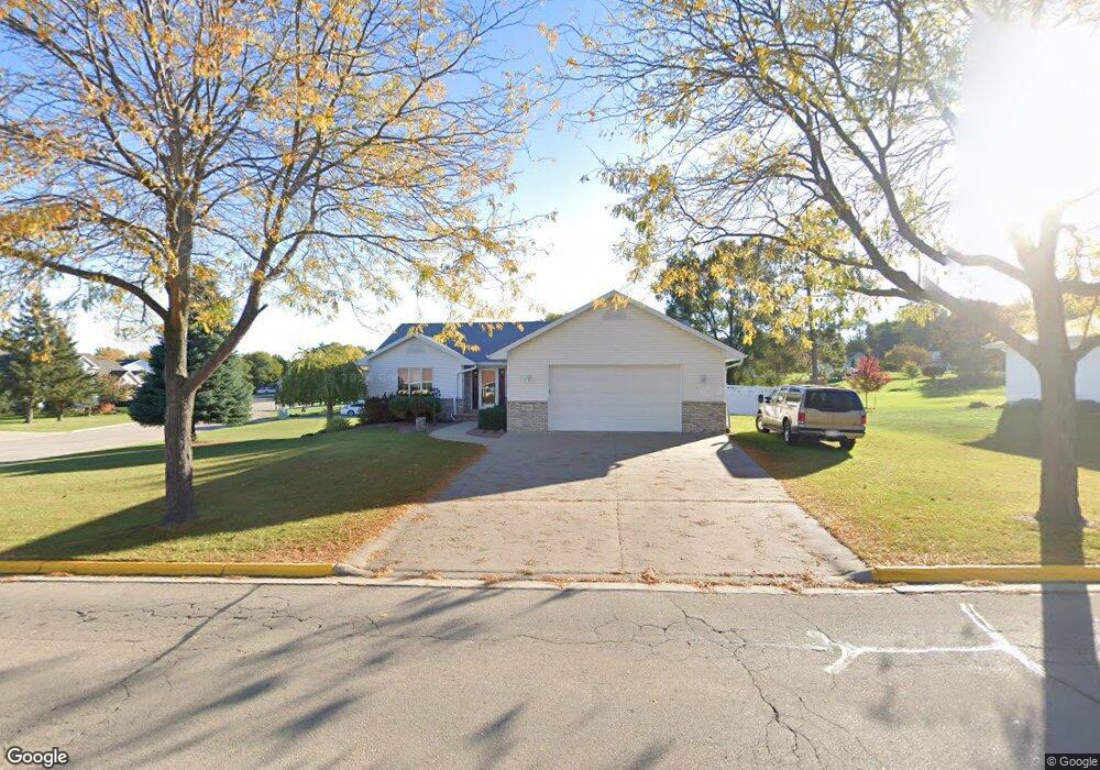
1902 Cedarhurst Dr New London, WI 54961
Estimated Value: $287,000 - $370,000
3
Beds
3
Baths
2,192
Sq Ft
$151/Sq Ft
Est. Value
About This Home
This home is located at 1902 Cedarhurst Dr, New London, WI 54961 and is currently estimated at $331,781, approximately $151 per square foot. 1902 Cedarhurst Dr is a home located in Waupaca County with nearby schools including Parkview Elementary School, New London Middle School, and New London High School.
Ownership History
Date
Name
Owned For
Owner Type
Purchase Details
Closed on
Aug 23, 2017
Sold by
Campbell Louis D and Campbell Sandra B
Bought by
Campbell Louis D and Campbell Sandra B
Current Estimated Value
Purchase Details
Closed on
Aug 7, 2008
Sold by
Lawton Holly
Bought by
Campbell Louis D and Campbell Sandra B
Home Financials for this Owner
Home Financials are based on the most recent Mortgage that was taken out on this home.
Original Mortgage
$168,150
Outstanding Balance
$110,848
Interest Rate
6.42%
Mortgage Type
New Conventional
Estimated Equity
$220,933
Create a Home Valuation Report for This Property
The Home Valuation Report is an in-depth analysis detailing your home's value as well as a comparison with similar homes in the area
Home Values in the Area
Average Home Value in this Area
Purchase History
| Date | Buyer | Sale Price | Title Company |
|---|---|---|---|
| Campbell Louis D | -- | None Available | |
| Campbell Louis D | $177,000 | None Available |
Source: Public Records
Mortgage History
| Date | Status | Borrower | Loan Amount |
|---|---|---|---|
| Open | Campbell Louis D | $168,150 |
Source: Public Records
Tax History
| Year | Tax Paid | Tax Assessment Tax Assessment Total Assessment is a certain percentage of the fair market value that is determined by local assessors to be the total taxable value of land and additions on the property. | Land | Improvement |
|---|---|---|---|---|
| 2024 | $4,391 | $186,400 | $30,300 | $156,100 |
| 2023 | $4,391 | $186,400 | $30,300 | $156,100 |
| 2022 | $4,144 | $186,400 | $30,300 | $156,100 |
| 2021 | $4,214 | $186,400 | $30,300 | $156,100 |
| 2020 | $4,270 | $186,400 | $30,300 | $156,100 |
| 2019 | $4,203 | $186,400 | $30,300 | $156,100 |
| 2018 | $4,014 | $186,400 | $30,300 | $156,100 |
| 2017 | $4,315 | $186,400 | $30,300 | $156,100 |
| 2016 | $4,191 | $180,700 | $29,500 | $151,200 |
| 2015 | $4,277 | $180,700 | $29,500 | $151,200 |
| 2014 | $4,201 | $180,700 | $29,500 | $151,200 |
| 2013 | $4,304 | $180,700 | $29,500 | $151,200 |
Source: Public Records
Map
Nearby Homes
- 1503 N Star Ct
- 1931 Southland Ln
- 1801 Southland Ln
- 1927 Southland Ln
- 1920 Southland Ln
- 1930 Pershing Rd
- 1910 Southland Ln
- 1825 Southland Ln
- E9481 W Beckert Rd
- 1508 Orchard Ct
- 1836 Oshkosh St
- 709 Robin St
- 0 Greenfield Dr Unit 50320953
- 622 W Washington St
- 1202 S Pearl St
- 112 E Law St
- 405 E Pine St
- 910 Algoma St
- 0 Shawano St Unit 50295803
- 0 Shawano St Unit 50257475
- 1814 Brynnwood Trace
- 1814 Brynnwood Tr
- 1904 Cedarhurst Dr
- 1903 Cedarhurst Dr
- 1901 Cedarhurst Dr
- 1808 Cedarhurst Dr
- 1812 Brynnwood Trace
- 1905 Cedarhurst Dr
- 1809 Cedarhurst Dr
- 1908 Cedarhurst Dr
- 2069 Pershing Rd
- 1810 Brynnwood Trace
- 1907 Cedarhurst Dr
- 1807 Cedarhurst Dr
- 1809 Brynnwood Trace
- 1804 Cedarhurst Dr
- 1805 Cedarhurst Dr
- 1805 Brynnwood Trace
- 1808 Brynnwood Trace
- 2055 Pershing Rd
Your Personal Tour Guide
Ask me questions while you tour the home.