


1902 Long Hollow Rd Rock Spring, GA 30739
Rock Spring NeighborhoodEstimated payment $3,353/month
Highlights
- Home fronts a pond
- Pond
- Private Yard
- 5.38 Acre Lot
- Vaulted Ceiling
- No HOA
About This Home
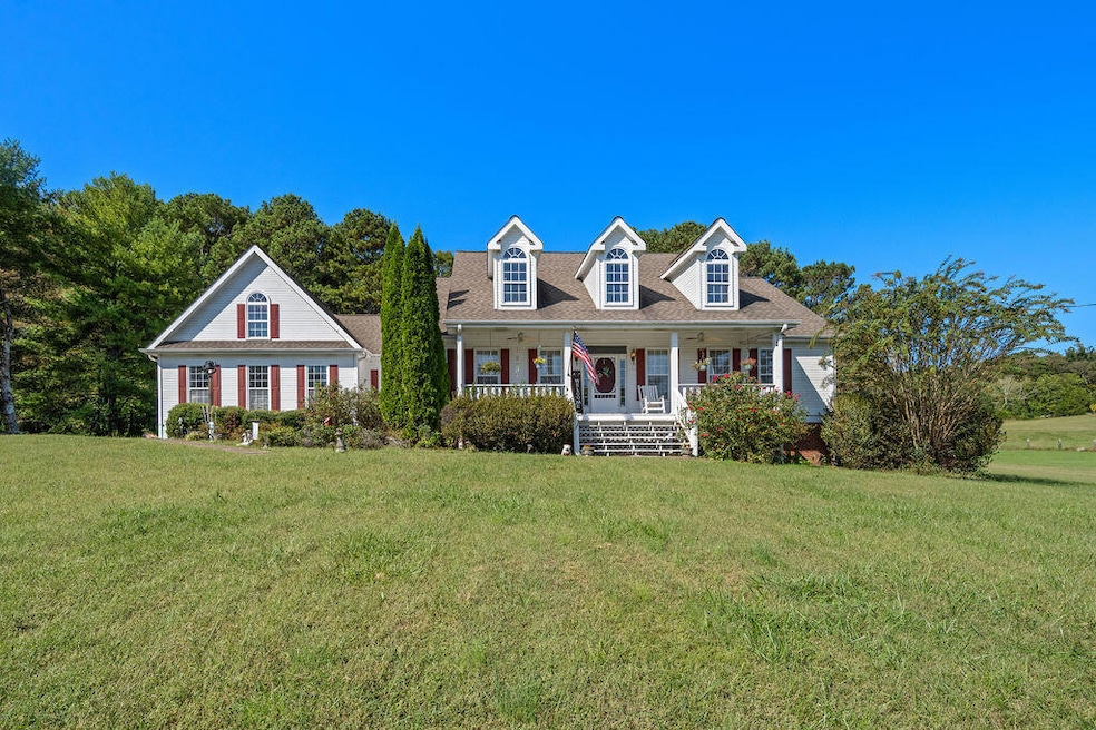
This is the one! Nestled on 5+ peaceful acres, this 2,700+ square foot home is complete with a seasonal pond, barn, detached garage and attached 2 car garage. Inside, you'll instantly feel the warmth of the cozy fireplace, vaulted ceilings, and rich hardwood floors that flow throughout the main living areas. The large kitchen is both functional and welcoming, featuring tons of cabinets, a center island and a pantry too! There's a lovely breakfast area with a bay window overlooking the backyard and also a separate dining room up front, that could easily be used as an office too. The open floor plan is perfect for entertaining and the great room is truly a showstopper with the custom built-in shelves and the wall of windows that lead to the screened in porch. Two bedrooms and a full bath are on one end of the home, a half bath is just off the front foyer and the laundry room, master bedroom and bonus room are on the other side of this incredible home. You'll love the ample closets and storage throughout. It feels worlds away from the rush of everyday life, yet it's conveniently located to US 27 and is only 19 miles from Chattanooga, TN. Come see for yourself what makes this home so special and all that it has to offer...schedule your private showing today! Seller is offering a 1 year home warranty with acceptable offer.

Home Details
Home Type
- Single Family
Est. Annual Taxes
- $3,316
Year Built
- Built in 1998
Lot Details
- 5.38 Acre Lot
- Lot Dimensions are 1014x822x348
- Home fronts a pond
- Private Yard
Parking
- 2 Car Garage
- Side Facing Garage
- Driveway
Home Design
- Block Foundation
Interior Spaces
- 2,729 Sq Ft Home
- Vaulted Ceiling
- Ceiling Fan
- Fireplace
- Utility Room in Garage
- Laundry Room
- Pull Down Stairs to Attic
Kitchen
- Breakfast Area or Nook
- Electric Range
- Microwave
- Dishwasher
Bedrooms and Bathrooms
- 3 Bedrooms
- Soaking Tub
- Bathtub with Shower
- Separate Shower
Outdoor Features
- Pond
Schools
- Rock Spring Elementary School
- Saddle Ridge Middle School
- Lafayette High School
Utilities
- Cooling Available
- Heating System Uses Natural Gas
- Gas Available
- Septic Tank
- Cable TV Available
Community Details
- No Home Owners Association
- Battlebluff Subdivision
Listing and Financial Details
- Assessor Parcel Number 03263 042
Map
Home Values in the Area
Average Home Value in this Area
Tax History
| Year | Tax Paid | Tax Assessment Tax Assessment Total Assessment is a certain percentage of the fair market value that is determined by local assessors to be the total taxable value of land and additions on the property. | Land | Improvement |
|---|---|---|---|---|
| 2024 | $2,084 | $163,287 | $24,867 | $138,420 |
| 2023 | $1,904 | $151,268 | $19,736 | $131,532 |
| 2022 | $1,531 | $134,722 | $20,494 | $114,228 |
| 2021 | $1,289 | $116,407 | $20,494 | $95,913 |
| 2020 | $2,861 | $98,980 | $20,494 | $78,486 |
| 2019 | $2,912 | $98,980 | $20,494 | $78,486 |
| 2018 | $2,619 | $98,980 | $20,494 | $78,486 |
| 2017 | $3,184 | $98,980 | $20,494 | $78,486 |
| 2016 | $2,503 | $98,980 | $20,494 | $78,486 |
| 2015 | $3,209 | $120,202 | $31,840 | $88,362 |
| 2014 | $3,047 | $120,202 | $31,840 | $88,362 |
| 2013 | -- | $120,202 | $31,840 | $88,362 |
Property History
| Date | Event | Price | List to Sale | Price per Sq Ft |
|---|---|---|---|---|
| 12/12/2025 12/12/25 | Price Changed | $585,000 | -0.8% | $214 / Sq Ft |
| 11/16/2025 11/16/25 | Price Changed | $589,900 | -1.7% | $216 / Sq Ft |
| 10/20/2025 10/20/25 | For Sale | $599,900 | -- | $220 / Sq Ft |
Purchase History
| Date | Type | Sale Price | Title Company |
|---|---|---|---|
| Deed | $253,000 | -- | |
| Deed | $40,000 | -- | |
| Deed | $25,000 | -- | |
| Deed | -- | -- |
Source: Greater Chattanooga REALTORS®
MLS Number: 1522309
APN: 03263-042
Disclaimer: Certain information contained herein is derived from information provided by parties other than Homes.com. All information provided is deemed reliable, but is not guaranteed to be accurate and should be independently verified.
![]() IDX information is provided exclusively for consumers’ personal, noncommercial use, that it may not be used for any purpose other than to identify prospective properties consumers may be interested in purchasing.
IDX information is provided exclusively for consumers’ personal, noncommercial use, that it may not be used for any purpose other than to identify prospective properties consumers may be interested in purchasing.
Data is deemed reliable but is not guaranteed accurate by the MLS.
Ten-X does not display the entire MLS of Chattanooga, Inc. database on this website. The listings of some real estate brokerage firms have been excluded. Some or all of the listings displayed may not belong to the firm whose website is being visited
Copyright© 2025 by Chattanooga Association of REALTORS®
- 195 Honeysuckle Dr
- 1476 Arnold Rd
- 1121 Arnold Rd
- 36 Pheonix Cir
- 1370 Old Highway 27
- 701 Bicentennial Trail
- 1003 Highway N Old 27
- 5602 Georgia 95
- 00 Georgia 95
- 136 Ginger Lake Dr
- 10180 Us Highway 27
- 285 Cooper Rd
- 514 Ginger Lake Dr
- 788 Long Hollow Rd
- 294 E Long Hollow Rd
- 100 Deer Ridge Ln
- 23 Willow Cir
- 16 Willow Cir
- 11 Willow Cir
- The Pearson Plan at Laurel Ridge
- 324 Avenue of The Oaks
- 4582 Highway N 27
- 876 Childress Hollow Rd
- 1185 Johnson Rd Unit Johnson
- 73 Muskett Dr
- 5 Overlook Trail
- 3434 Boynton Dr
- 69 Jason Dr
- 1100 Lakeshore Dr
- 1000 Lakeshore Dr
- 510 Mission Ridge Rd
- 304 Fort Town Dr
- 3438 E Ave
- 34 And 38 E Ave
- 2212 S Cedar Ln
- 218 Townsend Cir
- 33 Phillips Dr Unit B
- 50 General Davis Rd
- 153 Saddlebred Way
- 1252 Cloud Springs Ln