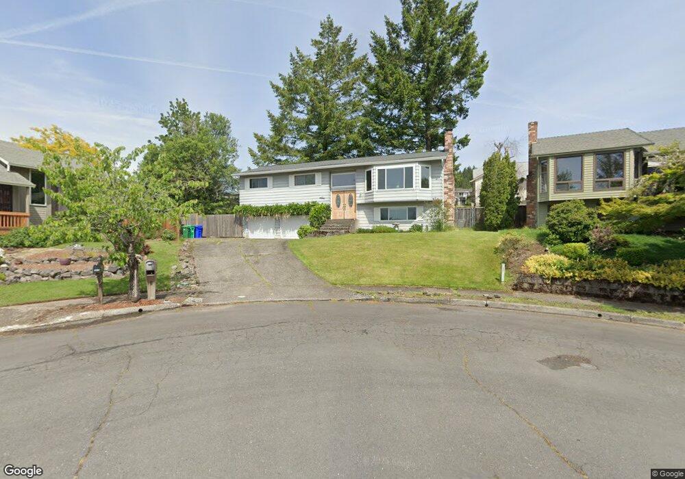
1904 SW 26th Ct Gresham, OR 97080
Southwest Gresham NeighborhoodEstimated Value: $512,000 - $534,000
4
Beds
7
Baths
2,044
Sq Ft
$258/Sq Ft
Est. Value
About This Home
This home is located at 1904 SW 26th Ct, Gresham, OR 97080 and is currently estimated at $527,315, approximately $257 per square foot. 1904 SW 26th Ct is a home located in Multnomah County with nearby schools including Dexter McCarty Middle School, Gresham High School, and Portland Adventist Elementary School.
Ownership History
Date
Name
Owned For
Owner Type
Purchase Details
Closed on
Nov 12, 2023
Sold by
Baird Alan M and Baird Mary Jill
Bought by
Baird Family Living Trust and Baird
Current Estimated Value
Purchase Details
Closed on
Feb 27, 2003
Sold by
Pine Brian J
Bought by
Baird Alan M and Baird Mary Jill
Home Financials for this Owner
Home Financials are based on the most recent Mortgage that was taken out on this home.
Original Mortgage
$145,600
Interest Rate
5.82%
Mortgage Type
Purchase Money Mortgage
Create a Home Valuation Report for This Property
The Home Valuation Report is an in-depth analysis detailing your home's value as well as a comparison with similar homes in the area
Home Values in the Area
Average Home Value in this Area
Purchase History
| Date | Buyer | Sale Price | Title Company |
|---|---|---|---|
| Baird Family Living Trust | -- | None Listed On Document | |
| Baird Alan M | $182,000 | Transnation |
Source: Public Records
Mortgage History
| Date | Status | Borrower | Loan Amount |
|---|---|---|---|
| Previous Owner | Baird Alan M | $145,600 |
Source: Public Records
Tax History
| Year | Tax Paid | Tax Assessment Tax Assessment Total Assessment is a certain percentage of the fair market value that is determined by local assessors to be the total taxable value of land and additions on the property. | Land | Improvement |
|---|---|---|---|---|
| 2025 | $6,167 | $303,040 | -- | -- |
| 2024 | $5,903 | $294,220 | -- | -- |
| 2023 | $5,378 | $285,660 | $0 | $0 |
| 2022 | $5,228 | $277,340 | $0 | $0 |
| 2021 | $5,096 | $269,270 | $0 | $0 |
| 2020 | $4,795 | $261,430 | $0 | $0 |
| 2019 | $4,670 | $253,820 | $0 | $0 |
| 2018 | $4,452 | $246,430 | $0 | $0 |
| 2017 | $4,272 | $239,260 | $0 | $0 |
| 2016 | $3,767 | $232,300 | $0 | $0 |
Source: Public Records
Map
Nearby Homes
- 2520 SW Towle Ave
- 3120 SW Orchard Place
- 1278 SW 27th Ct
- 1441 SW 23rd Ct
- 1320 SW 31st St
- 1261 SW Binford Lake Pkwy
- 1421 SW Binford Lake Pkwy
- 1859 SW Angeline Ave
- 1829 SW 17th St
- 1333 SW 19th Dr
- 3506 SW Battaglia Ave
- 3512 SW Battaglia Ave
- 3536 SW Battaglia Ave
- 3503 SW Battaglia Ave
- 3558 SW Battaglia Ave
- 1963 SW Myers Place
- 3582 SW Battaglia Ave
- 3604 SW Battaglia Ave
- 3539 SW Battaglia Ave
- 3510 SW Binford Ave
- 1929 SW 26th Ct
- 2695 SW Willowbrook Ave
- 1912 SW 26th Ct
- 2697 SW Willowbrook Ave
- 2675 SW Willowbrook Ave
- 1910 SW 25th St
- 1941 SW 26th Ct
- 1928 SW 25th St
- 1938 SW 26th Ct
- 1904 SW 25th St
- 2699 SW Willowbrook Ave
- 1934 SW 25th St
- 1955 SW 26th Ct
- 1946 SW 26th Ct
- 1785 SW 26th Ct
- 1800 SW 26th Ct
- 1960 SW 25th St
- 2656 SW Willowbrook Ave
- 1952 SW 26th Ct
- 1969 SW 26th Ct
Your Personal Tour Guide
Ask me questions while you tour the home.