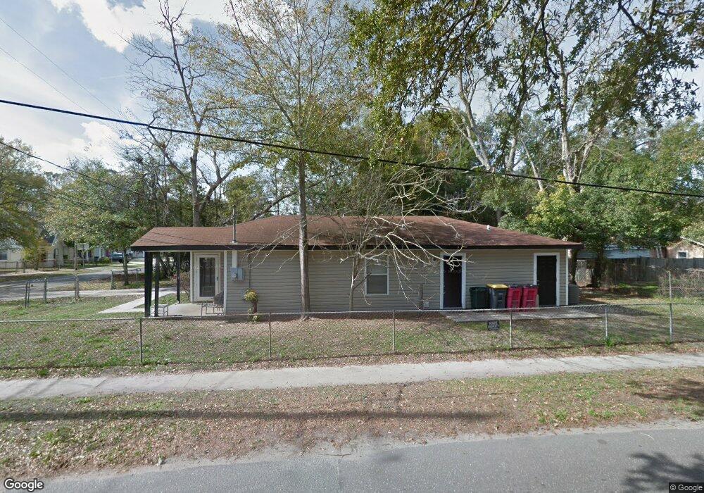
1905 W 2nd St Jacksonville, FL 32209
College Gardens/Mid-West NeighborhoodEstimated Value: $143,000 - $167,000
3
Beds
2
Baths
1,234
Sq Ft
$128/Sq Ft
Est. Value
About This Home
This home is located at 1905 W 2nd St, Jacksonville, FL 32209 and is currently estimated at $158,131, approximately $128 per square foot. 1905 W 2nd St is a home located in Duval County with nearby schools including Smart Pope Livingston Elementary School, Susie E. Tolbert Elementary School, and Lake Shore Middle School.
Ownership History
Date
Name
Owned For
Owner Type
Purchase Details
Closed on
May 24, 2002
Sold by
Habitat For Humanity Of Jacksonville Inc
Bought by
Dixon Fern
Current Estimated Value
Purchase Details
Closed on
Jan 17, 2002
Sold by
Newton Denise Evans and Newton Edwin Eugene
Bought by
Habitat For Humanity Of Jacksonville Inc
Purchase Details
Closed on
Jun 7, 2000
Sold by
Habitat For Humanity Of Jacksonville Inc
Bought by
Evans Denise Y
Home Financials for this Owner
Home Financials are based on the most recent Mortgage that was taken out on this home.
Original Mortgage
$54,472
Interest Rate
8.55%
Mortgage Type
Seller Take Back
Purchase Details
Closed on
Oct 5, 1998
Sold by
Mckinney Philip and Mckinney Jacqueline C
Bought by
Habitat For Humanity Of Jacksonville Inc
Create a Home Valuation Report for This Property
The Home Valuation Report is an in-depth analysis detailing your home's value as well as a comparison with similar homes in the area
Home Values in the Area
Average Home Value in this Area
Purchase History
| Date | Buyer | Sale Price | Title Company |
|---|---|---|---|
| Dixon Fern | $64,000 | -- | |
| Habitat For Humanity Of Jacksonville Inc | $51,600 | -- | |
| Evans Denise Y | $53,800 | -- | |
| Habitat For Humanity Of Jacksonville Inc | $5,000 | -- |
Source: Public Records
Mortgage History
| Date | Status | Borrower | Loan Amount |
|---|---|---|---|
| Previous Owner | Evans Denise Y | $54,472 |
Source: Public Records
Tax History Compared to Growth
Tax History
| Year | Tax Paid | Tax Assessment Tax Assessment Total Assessment is a certain percentage of the fair market value that is determined by local assessors to be the total taxable value of land and additions on the property. | Land | Improvement |
|---|---|---|---|---|
| 2025 | $542 | $44,748 | -- | -- |
| 2024 | $521 | $43,487 | -- | -- |
| 2023 | $521 | $42,221 | $0 | $0 |
| 2022 | $484 | $40,992 | $0 | $0 |
| 2021 | $471 | $39,799 | $0 | $0 |
| 2020 | $463 | $39,250 | $0 | $0 |
| 2019 | $451 | $38,368 | $0 | $0 |
| 2018 | $440 | $37,653 | $0 | $0 |
| 2017 | $428 | $36,879 | $0 | $0 |
| 2016 | $418 | $36,121 | $0 | $0 |
| 2015 | $596 | $45,353 | $0 | $0 |
| 2014 | $594 | $44,994 | $0 | $0 |
Source: Public Records
Map
Nearby Homes
- 1939 Hardee St
- 1952 W 2nd St
- 1938 W 5th St
- 1814 W 2nd St
- 1980 W 3rd St
- 1310 Fairfax St
- 1863 W 6th St
- 1732 Mcquade St
- 1402 Powhattan St
- 874 Robinson Ave
- 1003 Daniel St
- 1031 Powhattan St
- 2013 W 6th St
- 1978 Commonwealth Ave
- 1719 W 5th St
- 1015 Powhattan St
- 2221 College Cir S
- 1675 W 1st St
- 1708 Fairfax St
- 1778 Spires Ave