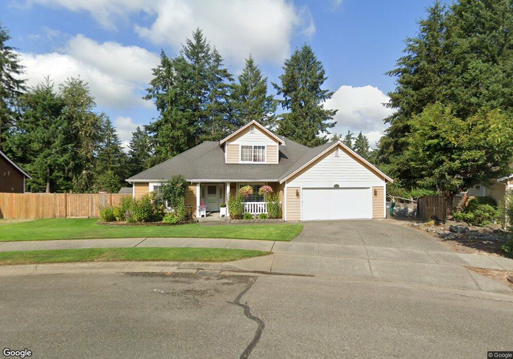
1906 Lois Ln Enumclaw, WA 98022
Estimated Value: $607,000 - $790,000
3
Beds
3
Baths
1,720
Sq Ft
$389/Sq Ft
Est. Value
About This Home
This home is located at 1906 Lois Ln, Enumclaw, WA 98022 and is currently estimated at $668,908, approximately $388 per square foot. 1906 Lois Ln is a home located in King County with nearby schools including Byron Kibler Elementary School, Enumclaw Middle School, and Enumclaw Senior High School.
Ownership History
Date
Name
Owned For
Owner Type
Purchase Details
Closed on
Nov 19, 2012
Sold by
Campbell Monica
Bought by
Corey Travis B and Corey Leslie R
Current Estimated Value
Home Financials for this Owner
Home Financials are based on the most recent Mortgage that was taken out on this home.
Original Mortgage
$211,105
Outstanding Balance
$142,794
Interest Rate
3.25%
Mortgage Type
FHA
Estimated Equity
$526,114
Purchase Details
Closed on
Feb 5, 2007
Sold by
Potter Darrel V and Bailie Robert M
Bought by
Campbell Monica
Home Financials for this Owner
Home Financials are based on the most recent Mortgage that was taken out on this home.
Original Mortgage
$238,000
Interest Rate
6.17%
Mortgage Type
Purchase Money Mortgage
Create a Home Valuation Report for This Property
The Home Valuation Report is an in-depth analysis detailing your home's value as well as a comparison with similar homes in the area
Home Values in the Area
Average Home Value in this Area
Purchase History
| Date | Buyer | Sale Price | Title Company |
|---|---|---|---|
| Corey Travis B | $215,000 | Wfg National Title Company | |
| Campbell Monica | $338,000 | Chicago Title |
Source: Public Records
Mortgage History
| Date | Status | Borrower | Loan Amount |
|---|---|---|---|
| Open | Corey Travis B | $211,105 | |
| Previous Owner | Campbell Monica | $238,000 |
Source: Public Records
Tax History
| Year | Tax Paid | Tax Assessment Tax Assessment Total Assessment is a certain percentage of the fair market value that is determined by local assessors to be the total taxable value of land and additions on the property. | Land | Improvement |
|---|---|---|---|---|
| 2024 | $5,308 | $553,000 | $212,000 | $341,000 |
| 2023 | $4,919 | $474,000 | $182,000 | $292,000 |
| 2022 | $4,406 | $541,000 | $208,000 | $333,000 |
| 2021 | $3,933 | $439,000 | $180,000 | $259,000 |
| 2020 | $3,590 | $357,000 | $123,000 | $234,000 |
| 2018 | $3,653 | $329,000 | $113,000 | $216,000 |
| 2017 | $3,243 | $298,000 | $103,000 | $195,000 |
| 2016 | $3,185 | $273,000 | $95,000 | $178,000 |
| 2015 | $3,176 | $264,000 | $90,000 | $174,000 |
| 2014 | -- | $252,000 | $91,000 | $161,000 |
| 2013 | -- | $194,000 | $73,000 | $121,000 |
Source: Public Records
Map
Nearby Homes
- 2881 Initial Ave
- 3555 Elmont Ave
- 1720 Garfield St Unit 4
- 1722 Harding St
- 23724 SE 436th St
- 3183 Roosevelt Ave
- 3189 Roosevelt Ave
- 3359 Terry Ln
- 43128 260th Ave SE
- 1705 Marshall Ave
- 23420 SE 448th St
- 2921 Frederickson St
- 1101 Wells St
- 1234 Lincoln Ave Unit A
- 1234 Lincoln Ave Unit B
- 2054 Roosevelt Ave
- 522 Harmony Ln
- 3436 Wetherbee Ln
- 1107 Griffin Ave
- 525 Grand Fir Dr
- 3283 Lois Ln
- 1890 Lois Ln
- 3233 Lois Ln
- 1885 Lois Ln
- 1882 Lois Ln
- 1900 Highpoint St
- 1930 Highpoint St
- 1875 Lois Ln
- 1938 Highpoint St
- 1880 Highpoint St
- 1870 Lois Ln
- 3230 Kibler Ave
- 1948 Highpoint St
- 3320 Kibler Ave
- 1863 Lois Ln
- 1909 Highpoint St
- 3119 Silver Springs Ave
- 1872 Highpoint St
- 1919 Highpoint St
- 1820 Lois Ln
Your Personal Tour Guide
Ask me questions while you tour the home.