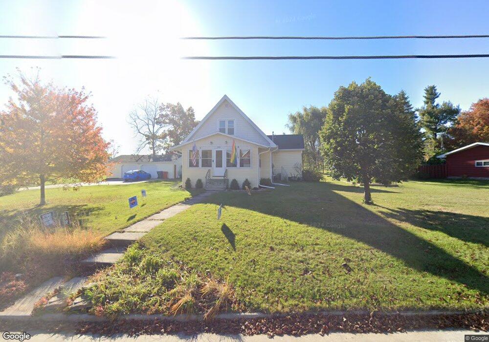
1906 Pershing Rd New London, WI 54961
Estimated Value: $244,000 - $297,000
--
Bed
--
Bath
--
Sq Ft
0.72
Acres
About This Home
This home is located at 1906 Pershing Rd, New London, WI 54961 and is currently estimated at $269,493. 1906 Pershing Rd is a home located in Waupaca County with nearby schools including Parkview Elementary School, New London Middle School, and New London High School.
Ownership History
Date
Name
Owned For
Owner Type
Purchase Details
Closed on
Oct 1, 2015
Sold by
Long Dan P and Lowe Barbara A
Bought by
Dan P Long Living Trust
Current Estimated Value
Purchase Details
Closed on
Apr 27, 2006
Sold by
Young Duane A
Bought by
Long Dan P and Lowe Barbara A
Home Financials for this Owner
Home Financials are based on the most recent Mortgage that was taken out on this home.
Original Mortgage
$93,600
Interest Rate
6.42%
Mortgage Type
New Conventional
Create a Home Valuation Report for This Property
The Home Valuation Report is an in-depth analysis detailing your home's value as well as a comparison with similar homes in the area
Home Values in the Area
Average Home Value in this Area
Purchase History
| Date | Buyer | Sale Price | Title Company |
|---|---|---|---|
| Dan P Long Living Trust | -- | None Available | |
| Long Dan P | $117,000 | None Available |
Source: Public Records
Mortgage History
| Date | Status | Borrower | Loan Amount |
|---|---|---|---|
| Previous Owner | Long Dan P | $93,600 |
Source: Public Records
Tax History Compared to Growth
Tax History
| Year | Tax Paid | Tax Assessment Tax Assessment Total Assessment is a certain percentage of the fair market value that is determined by local assessors to be the total taxable value of land and additions on the property. | Land | Improvement |
|---|---|---|---|---|
| 2024 | $2,953 | $126,100 | $35,600 | $90,500 |
| 2023 | $2,953 | $126,100 | $35,600 | $90,500 |
| 2022 | $2,738 | $126,100 | $35,600 | $90,500 |
| 2021 | $2,778 | $126,100 | $35,600 | $90,500 |
| 2020 | $2,826 | $126,100 | $35,600 | $90,500 |
| 2019 | $2,774 | $126,100 | $35,600 | $90,500 |
| 2018 | $2,655 | $126,100 | $35,600 | $90,500 |
| 2017 | $2,821 | $126,100 | $35,600 | $90,500 |
| 2016 | $2,697 | $118,400 | $35,500 | $82,900 |
| 2015 | $2,779 | $118,400 | $35,500 | $82,900 |
| 2014 | $2,729 | $118,400 | $35,500 | $82,900 |
| 2013 | $2,797 | $118,400 | $35,500 | $82,900 |
Source: Public Records
Map
Nearby Homes
- 1801 Southland Ln
- 1835 Southland Ln
- 1931 Southland Ln
- 1930 Southland Ln
- 1605 Cedarhurst Dr
- 1802 Nassau St
- 610 W Pine St
- 102 E Cameron St
- 1010 Smith St
- 1420 Division St
- 903 Smith St
- 907 W Beacon Ave
- 1109 Algoma St
- 200 W Beacon Ave
- 1975 Penny Ln
- 408 Wallace St
- 514 E Pine St
- 0 Shawano St Unit 50295803
- 0 Shawano St Unit 50257475
- 401 E Beacon Ave
- 1918 Pershing Rd
- 1926 Pershing Rd
- 1907 Pershing Rd
- 1838 Pershing Rd Unit 1840
- 1928 Pershing Rd
- 1930 Pershing Rd
- 1850 Pershing Rd Unit 1852
- 1830 Pershing Rd
- 1934 Pershing Rd
- 1833 Pershing Rd
- 1837 Pershing Rd
- 1826 Pershing Rd
- 1942 Pershing Rd
- 1825 Pershing Rd
- 1829 Pershing Rd
- 1943 Pershing Rd
- 1939 Southland Ln
- 828 Robin St
- 1104 Robin St
- 1951 Pershing Rd