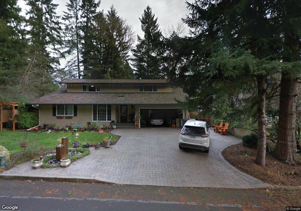
19060 SW Red Wing Ct Lake Oswego, OR 97035
Rosewood NeighborhoodEstimated Value: $913,940 - $964,000
5
Beds
3
Baths
2,735
Sq Ft
$341/Sq Ft
Est. Value
About This Home
This home is located at 19060 SW Red Wing Ct, Lake Oswego, OR 97035 and is currently estimated at $932,485, approximately $340 per square foot. 19060 SW Red Wing Ct is a home located in Clackamas County with nearby schools including River Grove Elementary School, Lakeridge Middle School, and Lakeridge High School.
Ownership History
Date
Name
Owned For
Owner Type
Purchase Details
Closed on
Feb 15, 2022
Sold by
Barnbrook Jason D
Bought by
Barnbrook Family Trust
Current Estimated Value
Purchase Details
Closed on
Sep 4, 2020
Sold by
Barnbrook Jason D and Barnbrook Jana
Bought by
Barnbrook Jason D
Purchase Details
Closed on
Jun 28, 2006
Sold by
Barb Russelyn D and Barb Brenda S
Bought by
Barnbrook Jason D and Barnbrook Jana
Home Financials for this Owner
Home Financials are based on the most recent Mortgage that was taken out on this home.
Original Mortgage
$45,900
Interest Rate
6.57%
Mortgage Type
Credit Line Revolving
Purchase Details
Closed on
Jun 1, 2004
Sold by
Boliek Scott J
Bought by
Barb Russelyn D and Barb Brenda S
Home Financials for this Owner
Home Financials are based on the most recent Mortgage that was taken out on this home.
Original Mortgage
$272,000
Interest Rate
6.09%
Mortgage Type
Purchase Money Mortgage
Purchase Details
Closed on
Dec 16, 2003
Sold by
Boliek Scott J and Boliek Teresa J
Bought by
Boliek Scott J
Home Financials for this Owner
Home Financials are based on the most recent Mortgage that was taken out on this home.
Original Mortgage
$199,300
Interest Rate
5.97%
Mortgage Type
Balloon
Purchase Details
Closed on
Jul 10, 1995
Sold by
Pearson William R and Pearson Carlen A
Bought by
Boliek Scott J and Boliek Teresa J
Home Financials for this Owner
Home Financials are based on the most recent Mortgage that was taken out on this home.
Original Mortgage
$150,000
Interest Rate
7.59%
Create a Home Valuation Report for This Property
The Home Valuation Report is an in-depth analysis detailing your home's value as well as a comparison with similar homes in the area
Home Values in the Area
Average Home Value in this Area
Purchase History
| Date | Buyer | Sale Price | Title Company |
|---|---|---|---|
| Barnbrook Family Trust | -- | None Listed On Document | |
| Barnbrook Jason D | -- | Amrock | |
| Barnbrook Jason D | $459,000 | First American | |
| Barb Russelyn D | $340,000 | First American | |
| Boliek Scott J | -- | First American | |
| Boliek Scott J | $187,500 | Transamerica Title Insurance |
Source: Public Records
Mortgage History
| Date | Status | Borrower | Loan Amount |
|---|---|---|---|
| Previous Owner | Barnbrook Jason D | $45,900 | |
| Previous Owner | Barnbrook Jason D | $367,200 | |
| Previous Owner | Barb Russelyn D | $272,000 | |
| Previous Owner | Boliek Scott J | $199,300 | |
| Previous Owner | Boliek Scott J | $150,000 | |
| Closed | Boliek Scott J | $75,000 | |
| Closed | Barb Russelyn D | $34,000 |
Source: Public Records
Tax History Compared to Growth
Tax History
| Year | Tax Paid | Tax Assessment Tax Assessment Total Assessment is a certain percentage of the fair market value that is determined by local assessors to be the total taxable value of land and additions on the property. | Land | Improvement |
|---|---|---|---|---|
| 2025 | $7,141 | $411,344 | -- | -- |
| 2024 | $6,955 | $399,364 | -- | -- |
| 2023 | $6,955 | $387,733 | $0 | $0 |
| 2022 | $6,561 | $376,440 | $0 | $0 |
| 2021 | $6,014 | $365,476 | $0 | $0 |
| 2020 | $5,861 | $354,832 | $0 | $0 |
| 2019 | $5,719 | $344,498 | $0 | $0 |
| 2018 | $5,501 | $334,464 | $0 | $0 |
| 2017 | $5,302 | $324,722 | $0 | $0 |
| 2016 | $4,776 | $315,264 | $0 | $0 |
| 2015 | $4,599 | $306,082 | $0 | $0 |
| 2014 | $4,534 | $297,167 | $0 | $0 |
Source: Public Records
Map
Nearby Homes
- 18863 Indian Springs Rd
- 4201 Childs Rd
- 18434 Sandpiper Cir
- 18541 Waxwing Way
- 18581 Timbergrove Ct
- 4123 Chad Dr
- 19368 Riverwood Ln
- 4023 Melissa Dr
- 18706 Bryant Rd
- 19130 SW 51st Ave
- 19200 SW 46th Ave
- 3777 Rivers Edge Dr
- 19222 Benfield Ave
- 19229 35th Place
- 5393 SW Wichita St
- 18300 Bryant Rd
- 18815 Hilltop Rd
- 4280 Bernard St
- 12 Dover Way
- 5275 SW Greenwood Cir
- 19060 Redwing Ct
- 19100 Redwing Ct
- 19061 SW Indian Springs Rd
- 19061 Indian Springs Rd
- 19081 Indian Springs Rd
- 19130 Redwing Ct
- 4753 Dawn Ave
- 19061 Redwing Ct
- 4753 SW Dawn St
- 19111 Indian Springs Rd
- 0 Indian Springs Rd
- 19111 SW Indian Springs Rd
- 19021 Indian Springs Rd
- 19101 Redwing Ct
- 19101 Redwing Ct
- 19001 SW Red Wing Way
- 19001 Redwing Way
- 4830 Dawn Ave
- 4830 SW Dawn St
- 18964 Redwing Way