Estimated Value: $241,627 - $296,000
3
Beds
2
Baths
1,664
Sq Ft
$161/Sq Ft
Est. Value
About This Home
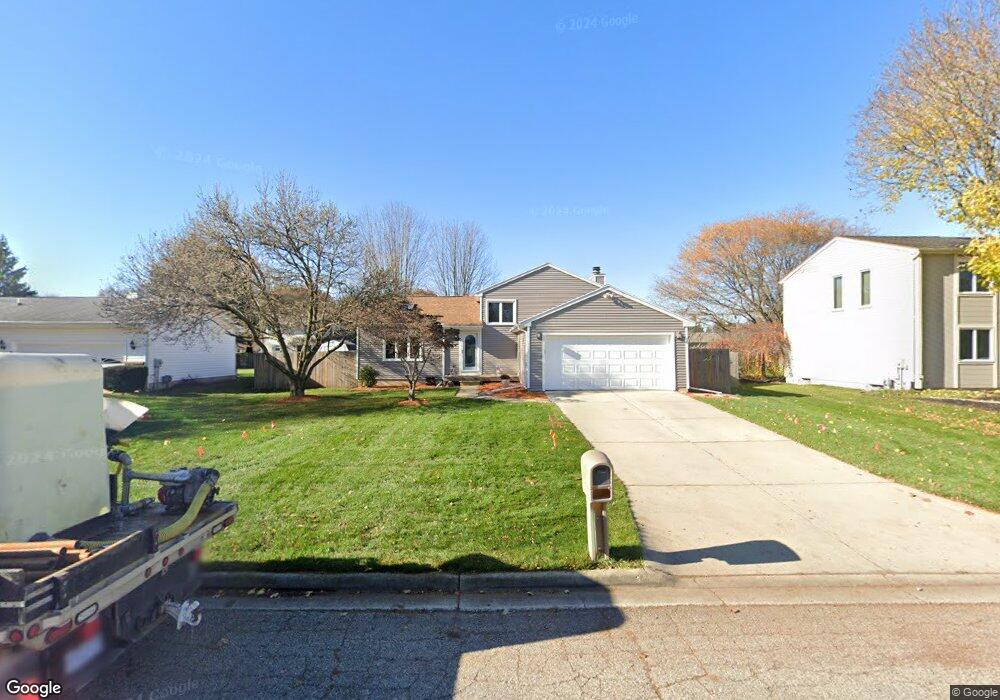
This home is located at 1907 Persimmon Path, Holt, MI 48842 and is currently estimated at $267,907, approximately $161 per square foot. 1907 Persimmon Path is a home located in Ingham County with nearby schools including Wilcox Elementary School, Washington Woods Middle School, and Holt Junior High School.
Ownership History
Date
Name
Owned For
Owner Type
Purchase Details
Closed on
Aug 21, 2001
Sold by
Bennett Diane R
Bought by
Snodgrass James and Dean Linnea
Current Estimated Value
Home Financials for this Owner
Home Financials are based on the most recent Mortgage that was taken out on this home.
Original Mortgage
$130,000
Outstanding Balance
$50,564
Interest Rate
7.11%
Mortgage Type
Purchase Money Mortgage
Estimated Equity
$217,343
Create a Home Valuation Report for This Property
The Home Valuation Report is an in-depth analysis detailing your home's value as well as a comparison with similar homes in the area
Home Values in the Area
Average Home Value in this Area
Purchase History
| Date | Buyer | Sale Price | Title Company |
|---|---|---|---|
| Snodgrass James | $155,000 | Midstate Title Company |
Source: Public Records
Mortgage History
| Date | Status | Borrower | Loan Amount |
|---|---|---|---|
| Open | Snodgrass James | $130,000 |
Source: Public Records
Tax History
| Year | Tax Paid | Tax Assessment Tax Assessment Total Assessment is a certain percentage of the fair market value that is determined by local assessors to be the total taxable value of land and additions on the property. | Land | Improvement |
|---|---|---|---|---|
| 2025 | $3,609 | $110,100 | $25,000 | $85,100 |
| 2024 | $3,420 | $105,500 | $24,900 | $80,600 |
| 2023 | $3,420 | $97,500 | $18,000 | $79,500 |
| 2022 | $3,268 | $90,700 | $18,000 | $72,700 |
| 2021 | $3,200 | $86,100 | $13,800 | $72,300 |
| 2020 | $3,233 | $73,400 | $13,800 | $59,600 |
| 2019 | $3,141 | $64,400 | $12,400 | $52,000 |
| 2018 | $3,123 | $59,600 | $12,400 | $47,200 |
| 2017 | $2,843 | $59,600 | $12,400 | $47,200 |
| 2016 | $2,819 | $57,700 | $13,000 | $44,700 |
| 2015 | $2,793 | $57,300 | $25,955 | $31,345 |
| 2014 | $2,793 | $55,400 | $25,955 | $29,445 |
Source: Public Records
Map
Nearby Homes
- 4942 Holt Rd
- 1895 Dean Ave
- V L 00 Holt Rd
- 5091 Runnymede Dr
- 2028 Auburn Ave
- 1584 Stonehaven Dr
- 5170 Beaumaris Cir
- 2021 Adelpha Ave
- 5071 Haddon Hall Dr
- 1532 N Eifert Rd
- 2245 Main St
- 4516 Wilcox Rd
- 0 Aurelius Rd Unit 282659
- 2301 Main St Unit 2301 2303
- 4662 Tolland Ave
- 4551 Glenberry Dr
- 2201 N Aurelius Rd
- 5386 Auben Ln
- 1485 Zuider Rd
- 5360 Holt Rd
- 1915 Persimmon Path
- 1899 Persimmon Path
- Vl Jacqueline Dr
- 0 Holbrook Unit 30049374
- 2053 Woven Unit 12
- 2611 Navigator 45 Ln
- 2645 Navigator 42 Ln
- 2655 Navigator 41 Ln
- 2617 Navigator
- 2635 Navigator
- 2645 Navigator
- 2611 Navigator
- 2033 Woven Unit 7
- 2060 Woven Unit 31
- 2066 Woven Unit 30
- 2068 Woven
- 2642 Little
- 4654 Les
- 4632 Les
Your Personal Tour Guide
Ask me questions while you tour the home.