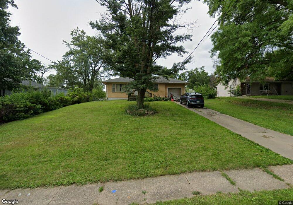
1908 Porter Ave Des Moines, IA 50315
Watrous South NeighborhoodEstimated Value: $162,000 - $206,000
2
Beds
1
Bath
781
Sq Ft
$232/Sq Ft
Est. Value
About This Home
This home is located at 1908 Porter Ave, Des Moines, IA 50315 and is currently estimated at $181,209, approximately $232 per square foot. 1908 Porter Ave is a home located in Polk County with nearby schools including Wright Elementary School, Brody Middle School, and Lincoln High School.
Ownership History
Date
Name
Owned For
Owner Type
Purchase Details
Closed on
Feb 11, 2014
Sold by
The Estate Of Victor Robert Dow Ii and Dow Victor Robert
Bought by
Dow Christopher and Dow Brian
Current Estimated Value
Purchase Details
Closed on
Dec 28, 2012
Sold by
Maxwell Nancy Ellen
Bought by
Dow Ii V Robert
Purchase Details
Closed on
Aug 16, 2010
Sold by
Dow R Arlene and Arlene Dowe R
Bought by
Maxwell Nancie
Create a Home Valuation Report for This Property
The Home Valuation Report is an in-depth analysis detailing your home's value as well as a comparison with similar homes in the area
Home Values in the Area
Average Home Value in this Area
Purchase History
| Date | Buyer | Sale Price | Title Company |
|---|---|---|---|
| Dow Christopher | -- | None Available | |
| Dow Ii V Robert | -- | None Available | |
| Maxwell Nancie | -- | None Available |
Source: Public Records
Tax History Compared to Growth
Tax History
| Year | Tax Paid | Tax Assessment Tax Assessment Total Assessment is a certain percentage of the fair market value that is determined by local assessors to be the total taxable value of land and additions on the property. | Land | Improvement |
|---|---|---|---|---|
| 2025 | $2,628 | $151,200 | $39,000 | $112,200 |
| 2024 | $2,628 | $144,100 | $36,500 | $107,600 |
| 2023 | $2,550 | $144,100 | $36,500 | $107,600 |
| 2022 | $2,530 | $117,100 | $30,300 | $86,800 |
| 2021 | $2,464 | $117,100 | $30,300 | $86,800 |
| 2020 | $2,554 | $107,300 | $27,600 | $79,700 |
| 2019 | $2,334 | $107,300 | $27,600 | $79,700 |
| 2018 | $2,306 | $95,400 | $24,100 | $71,300 |
| 2017 | $2,150 | $95,400 | $24,100 | $71,300 |
| 2016 | $2,090 | $88,000 | $21,800 | $66,200 |
| 2015 | $2,090 | $88,000 | $21,800 | $66,200 |
| 2014 | $1,960 | $82,500 | $20,100 | $62,400 |
Source: Public Records
Map
Nearby Homes
- 1810 Porter Ave
- 5410 SW 20th St
- 1616 Porter Ave
- 1616 Southlawn Dr
- 1605 Frazier Ave
- 1401 Cutler Ave
- 1419 Payton Ave
- 5120 SW 14th St
- 5013 SW 16th St
- 1500 Leland Ave
- 1304 Wall Ave
- 6107 SW 14th St
- 6001 SW 13th Place
- 4710 SW 16th St
- 1310 Leland Ave
- 1207 Kenyon Ave
- 1210 Highview Dr
- 1243 Hackley Ave
- 4916 SW 13th St
- 2501 Mckinley Ave
- 1914 Porter Ave
- 1904 Porter Ave
- 2002 Porter Ave
- 1840 Porter Ave
- 2007 Southlawn Dr
- 2008 Porter Ave
- 2003 Southlawn Dr
- 5440 SW 19th St
- 1915 Porter Ave
- 1915 Southlawn Dr
- 1830 Porter Ave
- 1911 Southlawn Dr
- 2011 Southlawn Dr
- 2014 Porter Ave
- 5437 SW 20th St
- 2015 Southlawn Dr
- 1907 Southlawn Dr
- 5448 SW 20th St
- 5439 SW 19th St