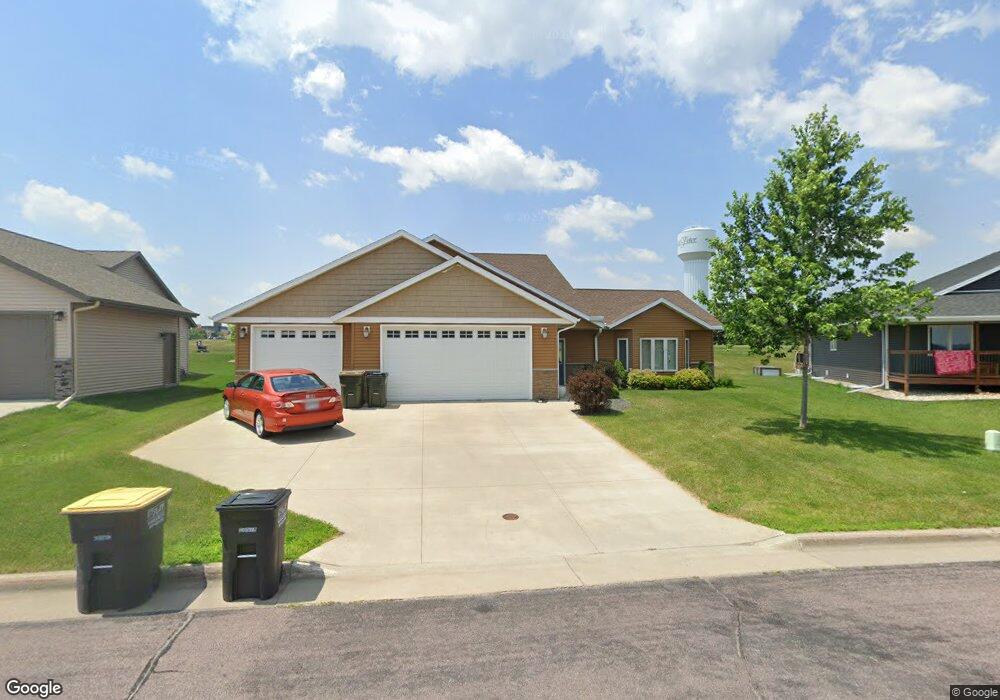
1909 Rock Ridge Ln Saint Peter, MN 56082
Estimated Value: $320,636 - $376,000
3
Beds
1
Bath
1,342
Sq Ft
$258/Sq Ft
Est. Value
About This Home
This home is located at 1909 Rock Ridge Ln, Saint Peter, MN 56082 and is currently estimated at $345,659, approximately $257 per square foot. 1909 Rock Ridge Ln is a home located in Nicollet County with nearby schools including North Elementary School, South Elementary Early Learning Center, and St. Peter Middle School.
Ownership History
Date
Name
Owned For
Owner Type
Purchase Details
Closed on
Sep 13, 2021
Sold by
Conroy Judy M
Bought by
Conroy Judy M and Conroy Revocable Trust
Current Estimated Value
Purchase Details
Closed on
Oct 29, 2013
Sold by
Bushard Todd
Bought by
Anderson Jesse L and Anderson Courtney C
Home Financials for this Owner
Home Financials are based on the most recent Mortgage that was taken out on this home.
Original Mortgage
$219,900
Interest Rate
5.5%
Mortgage Type
Land Contract Argmt. Of Sale
Create a Home Valuation Report for This Property
The Home Valuation Report is an in-depth analysis detailing your home's value as well as a comparison with similar homes in the area
Home Values in the Area
Average Home Value in this Area
Purchase History
| Date | Buyer | Sale Price | Title Company |
|---|---|---|---|
| Conroy Judy M | -- | None Available | |
| Anderson Jesse L | $229,900 | -- |
Source: Public Records
Mortgage History
| Date | Status | Borrower | Loan Amount |
|---|---|---|---|
| Previous Owner | Anderson Jesse L | $219,900 |
Source: Public Records
Tax History Compared to Growth
Tax History
| Year | Tax Paid | Tax Assessment Tax Assessment Total Assessment is a certain percentage of the fair market value that is determined by local assessors to be the total taxable value of land and additions on the property. | Land | Improvement |
|---|---|---|---|---|
| 2025 | $4,408 | $310,100 | $42,800 | $267,300 |
| 2024 | $4,022 | $310,100 | $42,800 | $267,300 |
| 2023 | $3,830 | $299,300 | $42,800 | $256,500 |
| 2022 | $3,704 | $277,000 | $42,800 | $234,200 |
| 2021 | $1,795 | $240,700 | $42,800 | $197,900 |
| 2020 | $3,498 | $230,900 | $37,000 | $193,900 |
| 2019 | $3,340 | $231,600 | $37,000 | $194,600 |
| 2018 | $2,836 | $222,800 | $37,000 | $185,800 |
| 2017 | -- | $192,200 | $0 | $0 |
| 2016 | $2,440 | $0 | $0 | $0 |
| 2015 | -- | $0 | $0 | $0 |
| 2011 | -- | $0 | $0 | $0 |
Source: Public Records
Map
Nearby Homes
- 2112 York St
- 2115 2115 Turpin St
- 2115 Turpin St
- 1850 Macintosh Ct
- 1810 1810 Haralson Ct
- 717 717 Upper Johnson Cir
- 1306 1306 N Washington Ave
- 808 Austin Dr
- 706 706 Lower Johnson Cir
- 809 W Traverse Rd
- TBD W Traverse Rd
- 730 N 9th St
- 730 730 N 9th St
- 2024 Essler Dr
- 2017 Essler Dr
- 2012 Essler Dr
- 2003 Essler Dr
- 1044 Cullen St
- 710 710 Dover
- 2001 Essler Dr
- 1907 Rock Ridge Ln
- 1909 1909 Rock Ridge Ln
- 1911 Rock Ridge Ln
- 1911 1911 Rock Ridge Ln
- 1907 1907 Rock Ridge Ln
- 1905 Rock Ridge Ln
- 1905 Rock Ridge Ln
- tbd Rock Ridge Ln
- 1914 Rock Ridge Ln
- 1913 Rock Ridge Ln
- 1906 Rock Ridge Ln
- 1903 1903 Rock Ridge Ln
- 1903 Rock Ridge Ln
- 1916 Rock Ridge Ln
- 1915 1915 Rock Ridge Ln
- 1915 Rock Ridge Ln
- 1917 Rock Ridge Ln
- 1901 Rock Ridge Ln
- 1918 Rock Ridge Ln
- 1905 1905 Boulder St